Quantcast
Channel: Singapore based Urban Explorers | One-North Explorers
Viewing all 26 articles
Browse latest View live

Anyer Lighthouse & Other Tales of Krakatau

$
0
0
This memoir is a continuation of our last post - The Lost Sultanate of Bantam.

Departing the town of Banten Lama, we headed west towards the direction of Anyer, a idyllic beach town where the Great Post Road starts in the west of Java. Home to an iconic lighthouse which we planned to visit, the beach is also one of the closest places on dry land in Java where one could see the infamous Krakatau, a volcano which erupted with cataclysmic results in 1883.

En route to Anyer, we passed by Cilegon, a city aptly nicknamed the "City of Steel". Cilegon is home to Krakatau Steel (after the volcano), the largest producer of steel in Indonesia. Apart from that, there were also several petrochemical refineries and cement plants in the area, giving it a real industrial feel.

Petrochemical plant in Cilegon
While traveling along the roads of Cilegon, the numerous potholes - caused by the daily activity of  heavy vehicles - made the ride feel like an off road adventure. Thank goodness we finished our paper cups of hot coffee before we reached the industrial zone.

On the trunk road to Anyer, we were treated with one of the biggest problems encountered by the locals in these parts - flooding. The two-lane road had been reduced to one narow strip which stayed dry. Some gung-ho motorcyclists who tried to ride through the flood waters ended up with stalled engines and had to push their bikes out of the water. As the flood water was knee-deep, virtually everyone tried to squeeze onto the dry strip, causing major congestion.

After being stuck in traffic for a good hour or so, we were on our way once again. The roads outside of the industrial zone were in stark contrast to the road we traveled on earlier and the rest of the ride was mostly pleasant.

Before long, I could spot coconut trees swaying in the gentle sea breeze and we soon reached a small cape which extruded out of Anyer beach. Hardi explained that he wanted to show me something interesting before we headed to the iconic lighthouse.

As we planted our feet on the sandy beach, Hardi said: "Take a look at the sand."

I noticed that the sand was darker than usual. Due to the beach's proximity to the active Anak Krakatau (child of Krakatau), the sand must have been mixed with volcanic soil (which is gray-black) by the current, giving it a beautiful brownish hue.

Dark volcanic soil mixed with the white sand of Anyer Beach
Anyer Beach was an interesting place and there were all sorts of activities going on around the area. One could choose from various forms of water recreational activities, lie in the sand or even go for a horse ride along the coast.

"The volcano is over there." Hardi pointed to the faint silhouettes in the horizon. "The tall one is Pulau Rakata, the short one is Anak Krakatau." said Hardi

The faint silhouette of Pulau Rakata and Anak Krakatau as seen from Anyer
The name Krakatau itself is something of a misnomer, as the volcano does not exist anymore. When Krakatau erupted with such immense power in 1883, the extent of the damage suffered in the explosion was so great that only a small part of the original volcano was left behind. Pulau Rakata - a collapsed volcano and one of three volcanoes which formed the original Krakatau - stands as an independent island today.

Krakatoa (Krakatau, Krakatao) / Indonesi by flydime, on Flickr
Creative Commons Attribution-Noncommercial-Share Alike 2.0 Generic License                                                                                                                      Eruption at Anak Krakatau by flydime

When Krakatau erupted, the explosion could be heard as far as 3,100 kilometres away in Perth, Australia. It is considered to be the loudest sound ever heard in modern history. The extent of the damage was horrendous. Officially, a hundred and sixty-five villages and towns were destroyed and a hunded and thirty-two were seriously damaged. The official death toll recorded by the Dutch authorities was 36,417 people though it could have been more. Many thousands more were injured by the eruption and the tsunamis that followed and two thirds of the island of Krakatau was destroyed as a result of the eruption.

Rogier Verbeek, a Dutch geologist living in Buitenzorg*, had done research in Krakatau just two years before it erupted. He was allowed to spend a few hours on the island and the samples he collected at that time proved to be essential in judging the geological impact of the eruption later in 1883. (*More information on Buitenzorg can be found in our post - In Search of Olivia's Tomb.)

Some guy tried to sell us these monsters at Anyer Beach.
Verbeek later predicted that new activity would manifest itself in the area where Krakatau once stood. This came true in December 1927 when evidence of a submarine eruption was seen in this area. A new island volcano named Anak Krakatau (Child of Krakatoa) rose above the waterline a few days later. Initially of pumice and ash, that island and the two islands that followed were quickly eroded away by the sea. However, a fourth island broke the water surface in August 1930 and produced lava that flowed faster than the waves could erode them.

Anak Krakatau has been growing considerably since then and it currently has a radius of roughly 2 kilometres and it's highest point measures in at around 324 metres (1,063 ft) above sea level. The volcano is growing at a rate of five metres every year.

This guy swam too hard. Sea wins, guy fails.
"When Krakatau erupted, it threw up a lot of rocks and lava. What I'm about to show you is a volcanic rock believed to have been thrown onto Anyer Beach by the sheer force of the explosion."said Hardi as we strolled along the sandy beach.

When we approached the aforementioned rock, I was amazed by its size. It was huge! If the story was indeed true, I could imagine the monstrous power the eruption of Krakatau had. Having said that, the eruption was about 13,000 times the nuclear yield of the Little Boy bomb that devastated Hiroshima so it was highly plausible that a piece of rock could be thrown this far across the sea.

"There is a more famous rock called Karang Bolong further down the road where many tourists visit. However, not many people know of this rock, which has a special cave." said Hardi as we continued towards the rock.

The person next to the rock should give a good sense of scale. The rock was massive!
There were two smaller rocks lying in the water near to the massive rock. Although they were darker due to the innumerable barnacles and algae growing on them, they did seem to be made of the same material as the large rock. Perhaps these three rocks were thrown onto the same area during the explosion? Or the smaller rocks could have probably rolled off the larger rock due to erosion by the salty sea air?

The rocks in the water reminded me of our very own Squance Rock* in Changi.
 (*As seen in our 2010 memoir - The Mysterious Grave of Batu Putih)
"Can you see a small cave at the foot of the rock?" asked Hardi. I nodded. "That cave was believed  to be used in the ancient days to keep something of importance. Numerous people have attempted to dig up the sand inside the cave but have found nothing. It said that the cave contained not just one but many important pieces of treasure and the cave was widely believed to be made by the pirates which roamed around the Sunda Straits" (probably from nearby Palembang, an area notorious for pirate activity)

As we stood at the mouth of the cave, I looked at the top part of the entrance. It seemed too perfectly flat and smooth to be natural. The height of the entrance was quite short and I had to crouch to enter the cave.

Once inside, I noted that the cave itself was quite small and could only accommodate about two to three adults at any one time. It led out to a smaller opening on the other side of the rock. There was all kinds of rubbish strewn about the interior of the cave -food boxes, plastic bags and some other unsavouray item which I should not mention here. Were these brought up to shore by the gentle waves of the sea, or thrown inside by visitors? Your guess is as good as mine. On one hand, Hardi mentioned that most of the rubbish found in Anyer is actually from Lampung province in Sumatra.

With our visit to the massive volcanic rock done and dusted, we made our way to the shining beacon of Anyer Beach - the famous Anyer Lighthouse.

I was amazed as we arrived at the base of the lighthouse, which was more than a century old.  Standing tall and slender at the height of 75 metres, the gleaming white lighthouse shimmered in the face of the setting sun, a sentinel of the coast and the rich history of Anyer. After years of guarding the coast, the lighthouse looks worn and weary. Rust can be seen in large patches on the exterior walls, a testament to the powerful effects of the corrosive sea air.

An old sign, worn and torn by the sands of time.
Although it seems ancient, the current lighthouse, also known as the Menara Bojong (Bojong Tower), is actually not the original lighthouse which guided and warded off ships along the Sunda Straits. The first lighthouse was known as Fourth Point and it was part of a series of lighthouses along the coast of West Java. In 1883, Fourth Point - which stood right next to the coastline - was unfortunately destroyed by the destructive eruption of Krakatau and the tsunamis which followed suit, along with almost everything else along the coast.

Following the annihilation of Fourth Point, a new lighthouse, named Anyer Lighthouse, was built by the Dutch a short distance from its ruins and construction on the new lighthouse was completed in 1885, a mere 2 years after Fourth Point's destruction. While Fourth Point was made from brick and mortar, Anyer Lighthouse was made out of pure steel, an huge improvement. Anyer Lighthouse was also moved further inland as a preventive measure against future volcanic activity and large waves.

Completed in 1885 under the order of King Willem III of the Netherlands
Apart from performing its basic duty of warding off ships with its powerful beam, it also served as a memorial for the victims who perished during the eruption of Krakatau.

Offshore mooring off the coast of Anyer Lighthouse

From our position at the base of the towering lighthouse, we walked over to the former location of Fourth Point. The zero kilometer marker of the Great Post Road (Der Grote Postweg) was placed right in the middle of the battered foundation of Fourth Point.

Marker Stone for Der Grote Postweg Zero Kilometer Mark and ruins
0 KM
Anjer - Panarukan
1806 AKL
On the marker, Anyer is spelt as Anjer in the Dutch manner. The year that the marker was created - 1806 - is also indicated clearly on the marker. However, since Fourth Point was only destroyed in 1883, it is possible that the marker was shifted here after the events of Krakatau. A tall lighthouse itself, Fourth Point could also have been the focal marker for Der Grote Postweg, hence the placement of the marker.

Lighthouse Keeper pointing in the direction of Krakatau
"The people who worked for the Dutch during the construction of the Great Post Road were called Rodi or forced labour. They were made to work for their meals, which was mainly just plain rice, and were never paid for their efforts." Hardi poignantly recalls.

The Great Post Road, which ran for 1000 kilometres from Anyer - our current location - to Panarukan in East Java, was completed in just a year through the effort of these Rodis. In West Java itself, traces of the road can still be found today in Banten and the city of Bandung.

A stone's throw away from the Zero Kilometre Marker, a second marker can be found. This blue stone was laid by the TNI AL's (Indonesian Navy) Office of Hydro-Oceanographical Study.

Hardi turned to me as I shot the last of my photos of the marker stones. "Shall we?"

Through his arrangements, we have been given a rare chance to ascend to the top of the lighthouse. With the sun setting fast, we headed towards the lighthouse entrance, eager to see the interior of the tower and the lamp before it turned completely dark.

As we stepped through the rectangular doorway of the lighthouse, the first thing I noticed was a door in the middle of the central column. This was the former storeroom for the fuel which lit up the lamp in the old days.


Ascending the metal staircase, I noticed whole floors that look to be severely rusted. There are 17 flights of stairs to be climbed which amounted to about 267 steps in total. Each floor had a window that allowed us to peek through for a nice view of the sea.

With no lighting installed inside the stairwell, the climb was dark and difficult and we relied solely on Hardi's small LED torch, which flickered on a few occasions (unlikely to be of supernatural reasons, Hardi blamed it on the recycled batteries he was using)


We arrived at level 6 of the lighthouse when I started feeling uncomfortable. There seemed to something watching us from the deep dark recesses of the room. I took a few shots but they all turned out blur and out of focus no mater how hard I tried to adjust my lens. This was also when I caught a whiff of something rotten. It was a really bad odour. I took my compass out of my pocket, half expecting to find the needle spinning around wildly. Nope, it wasn't.

"You smell that?" I asked Hardi. "Yes, I do." We stood there for a while. Nothing. After a short while, the smell was gone. Eager to push on to the top to catch the sunset, we continued on our ascent.

The lighthouse keeper, who had gone ahead of us to the next floor, came back down and asked if everything was alright. We explained what he had just experienced, to which he replied "This is a old lighthouse. That's actually quite normal. I just ask them to leave me alone as I am working and they usually do."

Hardi stops to take a breather and check his shots.
There were also numerous small holes in the walls and ceiling of the lighthouse, which we found on almost every floor. The lighthouse keeper explained that these holes were caused by gunfire. He claimed that during the Japanese occupation, Japanese soldiers would take prisoners into the lighthouse to be shot.

Lighthouse Keeper explaining the reason behind the numerous small holes
"Bullet holes" in the ceiling created by trigger-happy Japanese soldiers?
It was clear that the  lighthouse was quite solid judging from the many numbered plates that are joined together to form the walls, but the floors are badly rusted. The rusting in some parts of the floor seemed so bad that it looked in danger of collapsing anytime.

As we approached the top of the lighthouse, we could hear the gentle whirring of the lamp shade revolving around. We arrived at the room just below the top floor and found it to be of a unique design.

There were wires hanging from a hole in the ceiling (which leads to the lamp itself) and these were connected to the middle of a round drum placed in the centre of the round room. The drum had taken up almost all the space on the floor, leaving only the stairwell as the only place where one could walk. Sadly, the drum was badly vandalised as you can see from the pictures above.

In the old days, the room was home to a large discus which supplied fuel to the wick of the lamp above. Technology has since taken over and the lamp is now powered by electricity in the present day.

Heading up the final flight of stairs, I finally the first rays of light from the lighthouse lamp as I emerged from the stairwell. The bright bulb was enclosed in a fresnel lens, which helped to amplify the waves of light to reach great distances across the sea. It was fascinating to see the lamp us close for myself. I took a couple of pictures, some from within the lamp room, and some from the galley outside.

The shots from the exterior of the lamp room look much grubbier as the lamp room's glass windows looked like they have not been cleaned for years. But then again, it could have been a combination of the sea breeze and volcanic ash from nearby Anak Krakatau which caused the window to be so dusty.
 
The lamp flickered off for a few moments and
I quickly whipped out my camera to get this shot.
Who would have thought that such a seemingly small contraption could save so many lives at sea by projecting light beams for miles around the lighthouse?

After the interesting lamp room, it was time for us to head out to the galley outside. The breeze was pretty strong out here, and the height of the galley made the walk a little more intimidating, but the excellent view of the setting sun more than made up for the unnerving experience.

Sunset over the Sunda Straits, as seen from the top of Anyer Lighthouse.
Bakau, the southernmost tip of Sumatra, can be seen to the right of the picture.

View of the Anyer-Carita Road from Anyer Lighthouse
The galley walkway was rather narrow, and it felt a little jittery at times. From here, we could look out to Merak Port in the north and Sumatra in the northwest. The view was simply breathtaking.

The wind made everything a little more unnerving
As I made my way around the galley, I noticed an unusual hole in one part of the walkway. You could see right through the hole to the ground floor. Perhaps this was a drainage outlet for the galley?

Don't drop your keys.
Another view of the sunset in the southwest direction
(Incidentally in the general direction of Krakatau)
After the awe-inspiring experience, the sun was almost down. We were asked to descend the lighthouse at the behest of the lighthouse keeper. He explained that walking down the stairs would be much more difficult in the dark and hence we had to descend while there was still some natural light, or whatever was left of it

Well, I guess he was right. The steps were narrow and steep, and descending 17 flights of stairs in the dark was much harder than expected. Even with our torches, we had to descend slowly due to the steep incline of the staircase.

Before long, Hardi and I were back on level ground. I turned around and took a few more pictures of the lighthouse, now basked in the last glimpses of sunlight against the dark-blue sky.

The setting sun was a befitting end to my little trip to beautiful Banten. It had been an amazing day for me, visiting the remnants of the lost Sultanate, exploring the palace ruins, the complex water filtration system, the marker for Der Grote Postweg and the amazing Anyer Lighthouse with the wonderful company of Hardi.

I hope that these fragile pieces of history are not lost and forgotten over time. Surosowan Palace has already fallen victim to the unforgiving effects of time, and i hope that this does not erode into the other relics of the past which Banten has in abundance.

Afterall, Bantam was a great Sultanate which started off the spread of Islam in Indonesia. The future generations should be reminded of its achievements for years to come - not just in textbooks - but in person; field trips organized to Banten and Anyer should be a good start. This part of Indonesia's history is just too precious to fade away just like that.


Article & Photos copyright of Aaron "Six Stomachs" Chan

© One° North Explorers


Forgotten places, secret spots, historical sites or some interesting information to share. Is there a location/venue you want us to visit and document? Do you own or take care of a historical/heritage/interesting location/artifact or urban legend which you think would make a good feature?

Do drop us an email to discuss or provide/share us with a proposed location's/artifact’s accessibility, information and descriptions.


sgurbex @ gmail . com


.

The Betawi Bandit and the Captain from Ambon

$
0
0
Ask any person in Jakarta if they know who "Si Pitung" is and you'll probably hear them reply "Yes!" emphatically.

An Orang Betawi or descendant of the indigineous people who lived in the Batavia ( the old name of Jakarta) area during the Dutch colonial times, Si Pitung is probably the most well-known outlaw in the history of Indonesia and adored by many Indonesians even today.  However, like most folk legends, his story is a mix of historical hear-say and popular myths. Pitung was believed to have magical powers, making him impenetrable to all kinds of weapons and even bullets.

Artist's impression of the Betawi hero, Si Pitung, brandishing his twin goloks (Indonesian machete).
Illustrated by and used with the kind permission of Reza Ilyasa

I first heard of Si Pitung's name from our friend, Harry (from our affiliates, T.O.S.S. You can find them here). He told me that I absolutely had to visit Si Pitung's house to find out more about the story of this local Indonesian legend. Since I've always had a soft spot for folklore or stories / legends of such heroes, our conversation prompted me to embark on a trail to find out more about the local "Robin Hood" of Batavia.  

Si Pitung's house in Marunda

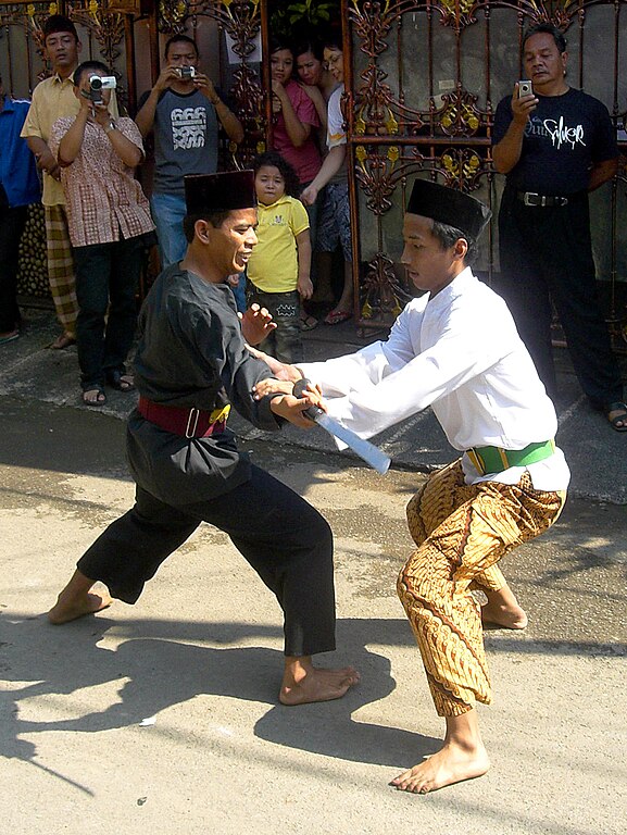
According to legend, Si Pitung was a robber who roamed around Batavia and its surrounding countryside between 1886 to 1894.

He was a cunning individual and gave the Dutch a tough time by outsmarting them every time when they tried to catch him. Many words have been said and written about him but, as many of these stories are derived from legend and superstition and not rooted in documented fact, it's hard to say just how true they are. Despite this, the leaders of the Betawi community swear by Si Pitung's stories, feats and powers, some of which border on the supernatural. He is almost always portrayed as a pious Muslim and an shining example of a social justice during the criminality and banditry of the Dutch East Indies era. Sensing the great social divide in Batavia, he utilised his dexterity and guile to steal from the rich to give to the poor.

Si Pitung was born in Pengumben, a village in Rawabelong (an area in present-day West Jakarta) to Bung Piung and Mbak Pinah. Si Pitung was sent to an Islamic school run by a gentleman named Haji Naipin as both his parents hoped for him to be a religious person who would help others when he grew up. After his evening prayers every day, he would train in the martial art of Silat under the watchful eyes of Haji Naipin until he became an extremely skilled practitioner.

Pencak Silat martial artists demonstrating how to disarm a Golok wielding enemy during a Betawi wedding.
Creative Commons Attribution-Noncommercial-Share Alike 2.0 Generic License

After Si Pitung grew up, he was asked by his father to sell two of their goats at the market in Tanah Abang (incidently around the same area where the tomb of Olivia Raffles is located - we have a writeup on that here and here). The two well-fed and healthy goats were quickly sold and he made his way home. He soon realised that the money he made had been stolen. He thought hard and recalled meeting a group of five men who had held him in conversation at the market, suspecting that one of them might have picked his pocket.


Si Pitung's House - Present Day

He knew right away that he would be in big trouble if he did not bring the money home safely. Flustered, he returned to the market where he found the five men. He confronted them for stealing his money and a fight soon ensued. Despite having the odds stacked against him, Si Pitung was able to overcome them with his impeccable Silat moves. It is said that his determination to recover the stolen money from the crooks gave rise to the nicknames Jago Betawi (translated as the Batavian Warrior) and Banteng Betawi (the Batavian Bull), a testament to his amazing perseverance and tenacity. 

Sugar-Cane-Knife-1 by Garrett Wade, on Flickr
The Golok or Indonesian Machete was believed to be Si Pitung's weapon of choice.
Creative Commons Attribution-Noncommercial-Share Alike 2.0 Generic License

He later joined forces with three other robbers, namely Ji'ih, Rais and Jebul, to carry out their now-famous pilfering feats around Batavia. Their targets were often the wealthy Bugis, Chinese and Arabs and the gains of their robberies were given to the orphans and the poor and needy, many of whom were enslaved by debts to their rich landlords. Some say that Si Pitung was not just an individual, but a gang of seven robbers who operated under the same name. The word Pitu in means seven in Javanese, and could have gave rise to this belief as well.

It is said that Si Pitung's burglaries never involved any act of violence and that he never resorted to murder nor even drew a single drop of blood from his victims. His agility enabled him to enter and leave the house of the rich quietly, and he never left any trace. Si Pitung's crime soon caught the attention of like this soon attracted the attention of the police and the Dutch police commissioner, referred to as Schout Hinne* by the Betawi storytellers, in particular. Scores of heavily armed men, guards and policemen were ordered to capture and lock up Si Pitung for good.

*Schout Hinne (literally Sheriff Hinne in Dutch) in these stories is most likely an actual police officer named Adolf Wilhelm-Verbond Hinne who was stationed in Batavia between 1888 to 1912.

An estuary village in Pulau Marunda, near Si Pitung's house.

The house of Si Pitung which I mentioned earlier actually belonged to a wealthy landowner in Marunda (a village north-east of Batavia) named Haji Sapiudin, who was a Bugis himself. The story of how it became Si Pitung's house is rather interesting. 
 
The most popular version tells of how Si Pitung used a clever ruse to trick Haji Sapiudin out of his money in the year 1892. Disguised as civil servants, they visited the house and handed Haji Sapiudin a letter instructing him to place his money at their disposal, offering an excuse that he was under suspicion of forgery. Therefore, they were there to collect the money, which had to be taken to the office of the Demang (the village head) to have its authenticity checked. Since such checks were common under the Dutch at that time, Haji Sapiudin naturally complied with the request and Si Pitung made off with his money.

Betawi people engaging in a cockfight using Bantam roosters in colonial Batavia.
Photo was taken between 1870 to 1900, and gives us an idea on how the locals were dressed during Pitung's time.
Source: Tropenmuseum (via Wikimedia Commons License)

 Haji Sapiudin later found out that he had been conned by Pitung's band of bandits, but instead of turning to the authorities for help, the patient Haji Sapiudin decided to investigate the reasons behind Pitung's actions and before long, he learnt all about Pitung's valiant deeds. A person with a kind heart himself, Haji Sapiudin then decided to allow the Betawi Bandit to use his house as a hideout, which Pitung did for several years before his unfortunate death.

The details of Pitung's eventual capture and death in 1912 is pretty murky, and there are several versions which Betawi storytellers tell off. One says that Pitung lost his mysterious powers after he cut his hair, resulting in his capture, while another says that he was killed by an egg thrown by a Dutch official, supposedly the only item which could penetrate his magical impenetrable skin. The most popular version, which was later used in a movie, depicts Pitung being killed by bullets made of gold; similarly his magical armour was broken by the golden bullets.

Red all over.

Hence, Si Pitung's House, or the Tall House of Marunda as it is commonly known, is not really where the Betawi Bandit lived, but rather his hideout from time to time. The wooden house, built in the architectural style of the sea-faring Bugis people, is supported by 40 wooden pillars and has 10 windows and 4 doors. This kind of house is common for coastal communities to nullify the danger caused by heavy waves rolling onto the shoreline.

Having a house on stilts helps to alleviate floods.
The trellis beneath the floorboard employs simple but effective engineering.

Peering into the house as I ascended the entrance ladder, I noticed that the entire house was not just painted in maroon on the outside, the inner walls and floor were coated with the same reddish colour as well. I understand from the caretaker that the house's floor was originally made of bamboo, but this has since been replaced with wood when the Indonesian government refurbished the place in 1972. The teakwood walls are original though, and were painted over during the refurbishment.

As I ascended the stairs and entered the living room, I was greeted by a faceless mannequin dressed in traditional Betawi clothing standing in a corner.

A peculiar drawing found above a doorway, which reminded me of a classical Hindu deity image.
The faded picture features a pair of pegasus-like creatures, with some Arabic inscriptions above.

Update: One of our helpful readers, Mr. Othman Husain, informed us that the pair of mythical creatures in the picture above are actually the Al-Burāq, a mythological steed which descended from the heavens to help transport the prophets in their ardous journeys. 

The most famous story involving the Al-Burāq is probably that of how one carried the Prophet Muhammad from Mecca to Jerusalem and back during the Isra and Mi'raj (the Night Journey) as described in the Quran.

Being a pious Muslim, it is therefore logical for the picture above to be displayed in Si Pitung's house. We'd like to thank Mr. Othman for unraveling the mystery behind the picture. 

A painting, which depicts a traditional Betawi wedding, decorates the guest hall.

While they could have made a statue of Pitung instead of using a faceless mannequin, the reason for this, or so it seems, is because no one knows what he looked like, according to the caretaker.  

Pitung's living room.
A faceless "Si Pitung" greets you as you enter his home.

As I stepped over a doorsill into a narrow corridor, I was greeted by a row of windows on my left and a small room on my right. The slats on the window blinds were barely open, letting in very little light, while a small faux kerosene lamp was employed as the sole light source inside the room. An electric light bulb was used in place of a kerosene wick and the yellowish light from the tungsten filament bounced off the reddish walls, which lent a gloomy feel to the whole place.

Leave a light on for me.

A plastic sign placed behind the doorsill read out the words "Kamar Tidur" (bedroom) aloud and a rope was hung across the entrance, suggesting that entry was prohibited.

There was a small canopy bed inside the room, and a dressing table and a wardrobe, both painted in maroon as well, completed the room's furnishings. I was perplexed at the low ceiling height of this bedroom. The occupant(s) must have been no taller than 5 and a half feet tall, or they would have had a hard time bending their heads forward to avoid hitting the ceiling!

Continuing further into the recesses of the house, I entered the dining area. This part of the house was shrouded in darkness, and my attempt to push the slats of the window blind upwards was foiled by a nail which was strategically hammered in to keep the slats in place. Whoever did this obviously wanted the place to be this dim on purpose. An open doorway at the back of the house was the only passage where the bright rays of the sun outside could shine through.

The darkness adds to the mystery.

While it was blazing hot outside, the thick wood used in the construction of the house ensured that it was cool inside. The roomy interior and narrow gaps between the wooden planks also allowed the passing breeze to flow through the house. It was actually quite comfortable.

After my eyes adjusted to the darkness, I found that there were several interesting artifacts lying around this part of the house and I decided to burrow further.

A dakon (the Javanese name for congkak) board lies atop a woven straw mat.

There was a dakon board placed on top of a woven mat to my left, while a dining table was placed on the right side. A curious looking stringed instrument was hanging on the wall above the dakon, prompting me to have a closer look.


Curious looking instrument.
The instrument had a long, thin neck and a round bottom presumably made from a dried coconut husk. Upon closer inspection, I was pretty convinced that the instrument was in fact a Rebab, a traditional Indonesian lute. While not as famous as the Angklung to audiences outside of the Indonesian archipelago, the Rebab is commonly used in Ondel Ondel* performances.

Ondel Ondel being performed in Jakarta.
(Image Source: Wikicommons)

*Ondel Ondel is actually a Betawi performance involving two gargantuan puppets, a male and a female, dancing to traditional folk music. It is usually performed on the streets of Jakarta and believed to ward off evil spirits and offer protection. During a typical Ondel Ondel performance, the high pitched wail of the Rebab can be heard amongst the accompanying drum beats and gongs.


Ondel Ondel performance. Note the usage of the Rebab in the music the puppets dance to.

This esoteric looking rebab was painted in the same reddish hue as the house itself, and the body of the instrument was painted to resemble a face. There was a hole in the middle of the body where the instrument's sound would come out from when the rebab was played, and this part was rightfully painted over as the "mouth" of the ornamental face of the rebab's body. The initials "C.B" could be found above the two pegs near the top of the rebab, a rough indication of the owner's name perhaps?


I also found an old rusty metal chest near to the rebab and I understand that this is a replica of one of the boxes Pitung used to store the money which he stole from the rich. The chest cover was welded and sealed shut so there was no way of opening it to see if there was any ancient money left over from the 19th century.


Next, I moved towards the dimly lit recess area where a full sized dining table was placed. I could imagine the inhabitants of the house trying to have their dinner uncomfortably under these poorly lighted conditions. Even the large window, which was large enough for a man to pass through, was not helping much in brightening up the room.The thought of Si Pitung using the poor visibility inside the house to make a hasty escape through this large window should the Dutch authorities come a-knocking immediately came to my mind. It was definitely plausible.


What drew my interest was not the dining table itself, which was your run of the mill wooden table, but a short cabinet placed against the wall nearby. Sitting on top of the cabinet was an ornamental ship made entirely of wood and metal. Maybe there was some secret scroll hidden inside this model like the one in The Adventures of Tintin: The Secret of the Unicorn (sorry if I spoilt the story for those of you who have not watched it yet).


With my walk around the house almost complete, I decided that it was time for me to move on to the next part of my day's programme. My friend and guide, Hardi (with whom I explored the ruins of Surosowan Palace and Anyer Lighthouse in Bantam) had promised to bring me to visit the obscure grave of a heroic soldier from Maluku (an archipelago formerly known as the Moluccas or Spice Islands) which was nearby in the Marunda area as well.

The curious thing about this grave was that it was located within the midst of a bonded area where imported items were temporarily stored. Fueled by my curiosity, I quickly boarded the car and was led by Hardi past rows upon rows of large, 40 foot containers after moving past a bucolic Customs security post. It was pretty unbelievable for such a relic to be located in such a secured area, much less a grave that was recognized by the city's Museum and Restoration Agency. The pot-holed and muddy track was not conducive for traveling at all, and it was a most uncomfortable ride as it started to drizzle outside, filling all the pot holes on the track with a mixture of mud and rainwater. Hardi choose to avoid all the pot holes (trying to guess the depth of a pothole filled with water can be pretty difficult) which made the zig-zag ride even more agonizing.

As we ploughed through the mud track leading to this interesting vestige, Hardi told me more about the supposed background of the person buried below. The grave belongs to an individual named Captain Jonker, whom like Si Pitung, is a local hero based purely on legend alone.

Jonker was a native of Ambon (the capital city of present day Maluku province or more commonly known as the Moluccas Islands in English) which is located more than 1,300 km away from Marunda. Apart from being known as Captain Jonker in the Marunda area (where the grave sits), he is also affectionately addressed as Tete Jonker back in Maluku, with the word Tete meaning "grandfather" in the Ambonese language. Jonker's story has been retold in both the Marundanese and Ambonese for many generations and he is revered as a hero by many.

The coastal town of Ambon, capital of present-day Maluku province, where Captain Jonker is from.

Like Pitung, Jonker has magical powers which granted him invincibility, uncanny strength and even the power to disappear at will! He is depicted as a soldier who later deserted his colonial employers as he was dissatisfied with the way the Dutch treated the locals. According to the Sejarah Teluk Jakarta (History of Jakarta Bay) book which was published by the Jakarta Museum and Restoration Agency, Jonker was stated as being from the Tumelaku Manifa area located west of Ambon Bay.  He was recorded to have joined the Dutch forces between 1661 to 1682 before he moved to Marunda in 1684.

During his time with the Dutch, Jonker had secretly made contact with local insurgents to find ways to push the Dutch colonial masters out of the Dutch East Indies. However, he was betrayed when one of his subordinates who reported his actions to the Dutch. Arrangements were made to eradicate Jonker and he was beseiged by Dutch troops from all directions and killed. Jonker was then buried in Pejonkeran, an area which was named in his honour.

Kapitan Pattimura
Captain Jonker is not to be confused with another popular hero, Kapitan (Captain) Thomas Matulessy, better known by his pseudonym Pattimura, who hails from Ambon as well. Pattimura joined the British forces after the Moluccas were wrested from the Dutch, but was dismissed when the islands were returned to the Netherlands after the Anglo-Dutch Treaty was signed in 1814. Appointed the rank of Kapitan by the people of Saparua, where he was born, Pattimura went on to lead an armed rebellion against the Dutch which culminated in the capture of the important Dutch fortress Fort Duurstede on 16 May 1817, where his forces killed off the colonial inhabitants, including the Dutch Resident - Juan van den Berg - and fought off Dutch reinforcements. Only van der Berg's five year old son was spared in the onslaught. Pattimura was later betrayed by a pair of Ambonese traitor siblings, Patih Akoon and Julian Tuankotta, and was captured by the Dutch and subsequently hanged in Fort Nieuw Victoria in Ambon together with three of his comrades in 1817. Due to his legacy and fierce patriotism, Pattimura was named as a Pahlawan Nasional (Nationa Hero) of Indonesia in 1976 by then-president Suharto. His namesake can be found in several places in Indonesia, particularly in the city of Ambon and his likeness has also been immortalized on the 1000 Rupiah note, brandishing a Golok (which happens to be Pitung's weapon of choice as well). 

Captain Pattimura's image on the 1000 rupiah note, brandishing his trademark Golok.

In the present day, Jonker's tomb receives visitors from all walks of life who come to the site either to pray or to meet the caretaker of the grave. The caretaker is well known among the locals as a diviner who is able to foretell the future after he imbibes alcohol and goes into a trance-like state. Some say that he has to get drunk in order to carry out his divination work because he had to become one with the spirit of Jonker, who was an alcoholic himself.

After making a turn into a seemingly endless mud track which branched off from the container yard, we finally arrived at the site where the tomb was located. Although many believe that the tomb has been here since Captain Jonker's death, it was actually located in a common cemetery near to Jakarta Bay and only moved to its present location in 1950. It is hard to imagine that the grave was just a pile of mud decorated with scant stone before the authorities constructed a proper shelter for the grave in 1965. The surrounding area was subsequently developed into the Marunda Industrial Bonded Zone as the city of Jakarta grew in size, which explains the weird location of the grave in the present day.

Many believe that Captain Jonker was a Muslim because his tomb faces west, incidentally the same direction towards Mecca. However, several crosses and crucifixes can be seen around the graveyard, confounding visitors to Jonker's true religion. Many Ambonese stick by the belief that Jonker was a Christian, like many Ambonese today.

It's hard to imagine a grave complex like this being located in the midst of an industrial bonded zone. 

As we approached the grave complex, it became apparent that the tomb was covered by a concrete roof with eight columns. The structure was painted mostly in red, and some of the surfaces were adorned with white ceramic tiles. I had to bend my head to enter the complex, and, although I was expecting to see Captain Jonker's name on the headstone, I was puzzled when I actually saw that this tomb belonged to another individual.

Not Jonker's tomb.

It was clear that this wasn't Jonker's grave. Judging by the following words which were inscribed on the headstone, it was evident that this was the grave of an individual named T.H.W Dotulong. A bottle with an open cap, was placed near the headstone, as if it was offered to Dotulong himself. Fresh flower petals were also spread over the earth which covered Dotulong's body.

The words,  etched in gold against black marble on Dotulong's headstone, read:

PATILASAN

GROOT MAYOR T.H.W. DOTULONG

Kema              12 Januari 1795
Sonder          18 Nopember 1888

Sakita esa sumerar kita
Sakita sumerar esa kita

After doing a little research, I found out that T.H.W Dotulong was in fact Tololiu Hermanus Willem Dotulong, a soldier and commander who hailed from the Minahasa area of the northern Celebes islands (now known as Sulawesi). He was one of several Minahasa soldiers which fought in the Java War between 1825 to 1830 for the Infanterie Nederlandsche Oost-Indie (Dutch East Indies Infantary) against Prince Diponegoro's rebellious forces.


Patilasan is a loan word from Javanese for a sacred place where ones' ancestors, or an important figure in the case of Dotulong, once stepped foot upon or lived. The title Groot Mayor stands for Sergeant-Major, the rank which was held by Dotulong where he was also bestowed the title of district head for the Sonder area in North Sulawesi.

Minahasa warriors of north Sulawesi. Circa 1884.

The headstone states that Dotulong was born in Kema, North Sulewesi in 1795 and died in Sonder in 1888. The verse below which says "sakita esa sumerar kita, sakita sumerar esa kita" is a motto for brotherhood and derived from the Minahasa people, it roughly means "we must spread ourselves (the Minahasa name and culture) far after we unite, and although we may be scattered after that, we remain united as one people."

The mysterious thing about this grave was the fact that there was another grave in Sonder which was supposed to be Dotulong's final resting place. Since Dotulong died in Sonder, it makes the most sense for him to be buried there since his body would have to be carried thousands of miles to where I was standing now.

Hence the question goes begging - who lies beneath this grave then?

Is this really the grave of Groot Major Dotulong?

As we were surveying the area around Dotulong's grave, we were approached by a man in a yellow raincoat who asked if we had came to pay our respects to Captain Jonker.

"Oh, his grave is inside here." he pointed to a larger building which was just beside Dotulong's grave when questioned on the whereabouts of Jonker's grave. From its external facade, it was hard to tell that this building housed the grave of someone prominent. It looked more like a shed where the caretaker kept his tools. It seems that one had to seek permission from the authorities or the caretaker himself to enter the grave complex according to the man, whom by now had identified himself as Pras, the caretaker of both Dotulong's and Jonker's graves. We identified ourselves and Pras gamely agreed to let us in to take a few pictures.

"I am surprised that a Singaporean would be interested in our culture and history" said Pras as he removed the lock from the wooden door. "I normally receive people from all over the country who come to the tomb to pray for luck and wealth, but never a Bule (a colloquial term for a foreigner)."

As the door was being opened by the caretaker, we stared at the dark doorway. There was no light inside the mausoleum, and there was a moldy stench emitting from within. The dark sky and brewing storm outside did not help much with our visibility. "Please" said Pras, gesturing for the both of us to enter the room. As Hardi entered the building, he said the words "Assamualaikum"(peace be upon you) softly and I followed suit out of respect.

In the darkness, we could make out a grave that was located somewhere near the middle of the room. The headstone had a unique top which was shaped like a roof, which was painted in red and plastered with white tiles like Dotulong's tomb outside.


However, while Dotulong's headstone was inscribed with more detail, Jonker's tomb was merely told visitors of his rank, name and the place he was from. The stars above his name is probably an indication of his rank - Jonker has three, while Dotulong has one. The name Jonker was also spelt as Yonker as the Dutch pronounciation of  the letter 'J' sounds like the letter 'Y'.

"That's where the body's head is, right below that rock." Pras said, pointing to a large long rock near to the headstone. The rock was curiously red in colour. "This rock was part of the original grave, before the Government helped to build this mausoleum." Pras added. I could see that there were 2 other gray rocks placed at the other end of the grave, presumably to indicate Jonker's feet.

I also noted that cigarettes were placed on the grave area as offerings to Jonker. This reminded me of the time where I found cigarettes being offered to the stone lions outside of the infamous Pasir Ris Red House many years ago. Taoists also offer cigarettes regularly to idols of Tua Li Ya Pek (大二爷伯), dieties who hail from the Netherworld of Taoist mythology in return for windfalls or wealth.

Cigarettes being offered to Captain Jonker.

Many believe that Dotulong was one of Jonker's subordinates, which explains the proximity of both graves. However, I strongly believe there is a certain degree of error in this, as Dotulong fought for the Dutch, while Jonker was believed to have fought vehemently against the Dutch.

As I stood at the end of Jonker's tomb, I held up my trusty compass and it indicated that his body was indeed facing feet first in a a west-northwest direction. Judging from a geographical standpoint, it is quite possible that Jonker's body was buried to face Mecca. Puzzled by this, I asked Hardi for his opinion. Hardi explained that the vast majority of the people in Marunda, or Batavia for that matter, were Muslim. Hence, the locals probably buried Jonker's body in accordance to Muslim tradition. Even Pras himself was not sure of Jonker's religion. "I've seen numerous people from both faiths visiting this grave. I guess the most important thing is not the religion you believe in here, but the amount of belief you place into that religion. Miracles do happen." 

Many would assume that Jonker was a Muslim because of the way that he was buried, but we all know that the Portuguese annexed Maluku in the early 1500 and converted many of the indigenous people to Christians. That was followed by Spanish and Dutch rule. Therefore, most Ambonese are pious Christians today.

Looking at Jonker's headstone, I could make out marking of a different faceplate which was probably removed and replaced with the current one later. The headstone looks evidently defaced and crudely patched with putty. To the right of the faceplate, there was a rectangular shape jutting out. I stood there and thought for a while. Could this have been a cross which was removed and replaced with the current rectangular plate? If it was, why was there a need to "cover" this (pun intended)?

A popular Ambonese legend tells of how Captain Jonker transformed himself and his wife into a pair of pigeons who flew from Batavia back to Maluku. For that reason, the pigeon is believed to be a symbol of returning home safely and it is employed in the Coat of Arms of the self-proclaimed Republic of South Maluku, which has remained in exile since its defeat to the Indonesian Armed Forces in 1950.

In the same complex, there was a small well located in the far corner of the room. We shone a torch inside and could see that the well was still filled with dark, murky water. This could well be the famous well of the Penjonkeran which was thought to have disappeared but was in fact covered by the four walls and the roof of the mausoleum.

Hardi and I both paid our respects to Captain Jonker and as we were about to leave, Pras asked if we would like him to perform some divination work for us. We politely declined. He then suggested that we come back here in the evening if we had anything we wanted to ask Captain Jonker as he would be receiving guests who come in search of answers, or simply to ask for luck and wealth.

As we stepped out of the mausoleum, I noticed that the storm had died down a little. Hardi gestured for me to follow him to the car. "Let's go for some Bandrek (a popular drink made from palm sugar, cinnamon, cloves and ginger)  to warm ourselves up." he suggested.

"Why not?" I thought. It would be good to ponder over the numerous questions I had over a cup fo piping hot Bandrek. The visit to Jonker's grave definitely gave rise to more questions than answers for me.

For those of you who love mysteries, I am still searching for the answers to these questions. Any help would be appreciated!

1. Why wasn't Captain Jonker buried in his native Ambon?

2. Could it be true that he was a Christian (like most Ambonese) who was mistakenly buried according to Muslim tradition by the Betawi people?

3. Was there a cross on Captain Jonker's headstone which was removed later? If yes, why?

4. Who actually lies beneath Dotulong's grave?

5. Why were the two buried near to each other when they were known to be loyal to different sides?


Readers who may have a clue are encouraged to drop us an e-mail or to leave a comment below. I would love to solve this mystery together with you. And yes, the Bandrek is on me.


Article & Photos copyright of Aaron Chan

© One° North Explorers


Forgotten places, secret spots, historical sites or some interesting information to share. Is there a location/venue you want us to visit and document? Do you own or take care of a historical/heritage/interesting location/artifact or urban legend which you think would make a good feature?

Do drop us an email to discuss or provide/share us with a proposed location's/artifact’s accessibility, information and descriptions.


sgurbex @ gmail . com


.

Labrador's Forgotten Relics

$
0
0
Note: This article was first penned by the writer in October 2012 and the article was completed and published on 5 June 2014. 

For those who take a stroll along its esplanade, it would be difficult not to notice the conspicuous presence of Labrador Nature Reserve's iconic red beacon - Berlayer Point Beacon (or Berlayer Beacon, for short). Situated at the narrow channel between Tanjong Berlayer on the Singapore mainland and Tanjong Rimau on the northwestern end of Sentosa Island, it is certainly heartening to see that this historical treasure has remained well preserved up until the present day.


The red beacon gleamed in the sun as I approached it to appreciate its simplistic elegance. Built in 1930, the seven metre tall square day beacon serves as the port (left-hand) side navigational guide for ships approaching the channel and doubles up as the marker for the shortest distance (around 240 metres) between Sentosa and mainland Singapore. Similarly, a green conical beacon (Tanjong Rimau Beacon) plays a similar role on the opposite shore along Tanjong Rimau beach, marking the starboard (right-hand) of approaching vessels.

The green conical beacon at Tanjong Rimau can be seen clearly from Tanjong Berlayer Point.

Nearby Berlayer's red beacon, a large craggy granite outcrop once stood as an important marker for ancient seafarers. Curiously, a similar granite outcrop could be found on Tanjong Rimau. While the rock on the Berlayer coast was simply called "Batu Berlayer" (Sailing Rock) by the indigenous Malays and "Lot's Wife" by British sailors (in the reference to the Biblical story where Lot's wife gets turned into a pillar of salt), the outcrops' resemblance to a pair of dragon's teeth gave rise to the Chinese name, "Long Ya Men" (Dragon Teeth's Gate).

These unique outcrops were so significant in maritime navigation that they were documented by famous Chinese explorers Cheng Ho and Wang Dayuan and would have been some spectacle if they had survived until the present day. Alas, the two outcrops were blown up by John Thomson, the Straits Settlements Surveyor, in August 1848 in order to widen the channel for ships to access the deep water anchorage between the mainland and the islands of Pulau Belakang Mati* and Pulau Brani.

*Pulau Belakang Mati was the former name of Sentosa Island before it was renamed following the announcement of plans to turn the island into a tourist destination. The name Sentosa (which means tranquility) was picked as the winning entry of a contest held by the Singapore Tourist Promotion Board (STPB, presently the Singapore Tourism Board) in 1970. 

Interestingly, the prize award of $500 was shared among 5 winners, all whom thought of the same name - Sentosa. The winners were namely Mr. E.C. Goh, a journalist, Mr. Edward Leong, the managing director of an advertising firm, Dr. S.Y. Lee (Dr. Lee Suan Yew, the younger brother of Mr. Lee Kuan Yew and a medical practitioner), Mr. Tan Siak Soon, a waiter in training and Encik (Malay for Mister) Sahat bin Dol, a bus driver with the Singapore Traction Company. The prize was awarded by then-chairman of the STPB, Mr. Runme Shaw at the Board Room of Tudor Court .[1]

Sentosa was also called Pulau Panjang according to 19th century sea charts, as well as Burne Beard Island in a 1780 map and Pulau Niry, Nirifa in a map dating much earlier to the late 1600s. There are many theories which explain how Pulau Belakang Mati (the island of death from behind) got its unfortunate name but I guess we'll leave that story for a future article.

The replica of "Long Ya Men" being built at Tanjong Berlayer Point in 2005.
In July 2005, a six metre tall replica of Batu Berlayer was erected near to its original site as part of a celebration of the 600th anniversary of Admiral Cheng Ho's maiden voyage from Nanjing, China. In fact, the authorities had originally planned for this replica to replace the red beacon but this thankfully was met with much resistance from the Singapore Heritage Society, who argued that the beacon was itself a heritage site and should not be destroyed. In the end, the replica of Batu Berlayer was built just meters away from the red beacon.

As time grew by, more ships began to seek relief from their long, arduous journeys at this anchorage and there was a need for a proper harbour to address the growing numbers of ships. Naturally sheltered by Pulau Belakang Mati and coupled with its suitable deep waters, Keppel Harbour was therefore born, a harbour of most significant importance which was built in these straits in 1886. It fit the requirements of the British perfectly in their attempts to establish a Far East maritime colony in this part of the world.

While it was called the New Harbour after it was established, the harbour was later named after Sir Henry Keppel, a naval officer who visited Singapore on several occasions as between 1848 to 1903 primarily to reduce the rampant pirate activity in the Straits Settlements (Singapore, Malacca and Penang). Shortly after arriving in Singapore, Sir Keppel was the one discovered the natural, deep-water harbour prior to its establishment as the New Harbour and it was finally renamed Keppel Harbour by Sir Alexander Swettenham, the Acting Governor of the Straits Settlements, during Sir Keppel's visit at the age of 92 in April 1900.

The western limit marker of Keppel Harbour.
A tall white obelisk can be found near to the red beacon and beside it, a British pillbox faces the sea as part of Batu Berlayer's defence line, one of several concrete machine gun pillboxes along the coastline. Situated about 550m apart from each other, the pillboxes were built to resist invasion from the southern sea. This particular pillbox was built to protect the 12-pound gun on top of Berlayer Point.

While there has been much speculation behind the obelisk's actual role, it was erected by the British to serve as the western harbour limit of Keppel Harbour at Tanjong Berlayer Point. It was also said to mark the southernmost tip of the Asia continent* before the land around Tanjong Berlayer Point was reclaimed by the Singapore government.

The pillbox at the foot of Tanjong Berlayer Point's cliff.
*A subsequent location for the southernmost tip of Asia continent has also been claimed by the Sentosa management after the official opening of the Sentosa Causeway, which links Sentosa island to the mainland, on 15 December 1992. This point, which is commemorated by a plaque, can be found on a tiny man-made islet off Palawan Beach, the southern coast of Sentosa island, and is accessible via a suspension bridge.

Batu Berlayer Anti Motor Torpedo Boat (AMTB) Battery.
A Radio Antenna Tower, which was later added within the premises of the Batu Berlayer AMTB Battery.
Behind the obelisk and pillbox, a watchtower peeks out among the lush greenery atop an impossibly steep cliff, a great vantage point to monitor the surrounding waters and protect the entrance to the harbour. The watchtower was the No. 2 Director Tower of the Batu Berlayer Anti-Motor Torpedo Boat (AMTB) battery, which was a part of a larger scale defence line known as Fort Pasir Panjang or the Labrador Battery.  The Batu Berlayer AMTB Battery and the neighbouring Labrador Battery were constructed to primarily defend the western approach to Keppel Harbour.

The Batu Berlayer AMTB No. 2 Director Tower as seen from its base.
There has been much confusion about the role of this battery, and there has even been speculation about the place being a fortress. However, our friend, Peter Stubbs, a British military historical expert and owner of the FortSiloso.com website, gives a detailed explanation about the Batu Berlayer AMTB Battery in his article, as replicated below:

"Standing high on Batu Berlayar, the remains of the gun batteries that were once here may look like a fortress to some, but the impression is false. Batu Berlayar in its various incarnations was never designed to be self-defending. It was of course part of the much greater so-called ‘Fortress Singapore’ gun batteries. However, these being coast batteries could not form a fortress. Defences needed to make a fortress were never built in Singapore, which was one of many reasons for the fall of Singapore on 15th February 1942."[2]

Rusty.
The Batu Berlayer AMTB battery is made up of 2 gun emplacements, each with its own director tower, and a compound of fortified rooms used for storage of munitions, transmission of radio signals and other essential operations. The director tower behind each gun, which had a bird's eye view of the western approach, provided critical information (such as the target's distance) to the gunners in order for them to take down their targets successfully. Both emplacements were built to face the southwest, and their main arc of fires overlapped with that of the Labrador Battery to its right and Fort Siloso to its left. Any enemy craft which was foolish enough to get close enough these waters would soon find out about the deadly consequences.

I understand from Peter that the first AMTB Battery was completed in 1892, where it was part of an overall defence plan of the harbour entrance which depended on the firepower of two quick-firing guns and two machine guns at Berlayer Point, as well as the infantry garrisons of Passir Panjang (an old spelling variation of Pasir Panjang by the British) and Siloso covering the western mine field.

No. 2 Director Tower as seen from inside the battery.
The ‘Straits Settlements Defence Scheme, September 1893’ originally listed 1 QF gun (quick-firing gun, a weapon which can fire at a fast rate) and 1 machine gun as being at Berlayer Point, under the command of Fire Commanders, Lt. Langdon and Lt Eady of Passir Panjang. The battery's armaments were subsequently increased to 1 QF gun and 2 machine guns as stated in the ‘Straits Settlements Defence Scheme, September 1894’.

Aerial view of the battery from No. 1 Director Tower.
In a room of the Post War Harbour Board tower constructed at Batu Berlayar.
In December 1896, the armament reported by the ‘Straits Settlements Defence Scheme’ then was “1 6-Pounder QF and 2 machine guns” (incidentally the first reference Peter has seen referring to the calibre of the QF Gun). Further records also show that there were two 6-Pounder QF guns at Berlayer Point on 1st January 1898, having been taken there from Tanjong Katong. However, no mention of any machine guns were made in this report.

The list of Approved armaments showed that the QF Guns were still there on 1st January 1899 and one of these was placed in an embrasure which could be found at the beach level. This gun was pointed in the direction of Pulau Belakang Mati and could be utilised to ambush and annihilate any Motor Torpedo Boats which snuck past the main guns.  It is unclear when the rock at Berlayer Point was hollowed out to form this gun emplacement.

The alleged entrance to the "secret tunnel" which leads to Sentosa.
The inaccessibility of the "tunnel" further perpetuated the urban legend.
The embrasure is often wrongly speculated to be the entrance of a secret tunnel which allegedly ran below the channel and provided subterranean access to Pulau Belakang Mati. In fact, the reality show "Hey Singapore!", which originally ran in the 90s, dedicated a segment to unraveling the mystery behind this alleged tunnel, but to no avail. They showed shots of what they believed was the entrance to the tunnel (which happened to be the embrasure of the QF gun), some shots of the embrasure's interior as well as a similar opening on the opposite coast of Tanjong Rimau, further fueling this speculation.

Interior of the "secret tunnel" entrance, which was, in fact, the beach level embrasure housing the 6-pounder QF gun.
A shaft inside the embrasure leads up to the AMTB battery and was probably used to lower shells downwards.
As much as we'd like to believe that there is an underground tunnel linking Tanjong Berlayer to Sentosa, this would be highly unlikely as the other end of the tunnel would have to be located somewhere within Fort Siloso, and not on the foot of the cliff face along Tanjong Rimau coast as many believe, since this would expose soldiers emerging from the tunnel to enemy fire. A chat with Peter, who knows every inch of Fort Siloso like the back of his hand, reveals his firm belief that there is no entrance located within the fort itself.

Peter also believes that Berlayer Point was probably unarmed from September 1900 onwards as there were no references to the battery in the list of Singapore’s Approved Armaments from that point onwards, as well as the following years after that. Since records show that Fort Pasir Panjang acquired two 6-Pounder QF Guns around the same time, it is believed that the guns were moved from Batu Berlayer AMTB to Pasir Panjang to replace the inferior 7-inch R.M.L (rifled muzzle-loading) Guns at the emplacement located nearest the path to the beach. This was because the 7-inch R.M.L guns neither had sufficient range accuracy nor rapidity of fire for effective coastal defence. The engineer of Fort Pasir Panjang, H.E. McCallum, even referred to the 7-inch R.M.L guns as being ”the worst in the service”.[3] 

A replica 6-Inch QF Gun in the Fort Pasir Panjang No.2 6-Inch Emplacement (More info from fortsiloso.com here)
Faye, one of our team members, having a chinwag with one of the QF gunners.
To give a rough comparison of the difference in performance between the two, the 7-inch R.F.L gun could only fire 2 to 3 rounds per minute, while the 6-pounder QF guns could achieve a firing rate of 25 to 30 rounds per minute, an alarming difference of 10 times!

A Signal Station was built on Berlayar Point when the armament was removed and remained there until the late 1930s. Subsequently in the Defence Scheme of 1913, it was mentioned that there were two .303 Maxim Machine Guns situated at Berlayer Point. Batu Berlayer was to be re-fortified following the events of pre-WW2 brewing in Europe and Northeastern Asia, and the layout of AMTB defences for Singapore was approved on 4th November 1937, where the Army Council listed two twin 6-Pounders for Batu Berlayer. There were also to be three 30° fixed Defence Electric Lights (D.E.L), searchlights used to sweep the area to detect and illuminate enemy marine vessels.

The AMTB Emplacements of Batu Berlayer were complete in 1941 and the manning for the battery consisted of 2 British Officers, 55 British Other Ranks, 8 Indian soldiers  and 11 Malay soldiers. In October 1941, two 12-Pounders were reported as being placed at the battery with no Twin 6-Pounders being available. While it was fully ready for war, the battery never realised its full potential. Extracts from the Faber Fire Command War Diary stated that the 12-Pounders could not bear landwards and, therefore, never did partake in any action but Battery Commander Capt T.E. Pickard of the 31 Coast Battery RA, which manned the AMTB, recalled that “bombs fell in the sea, off the point”. Some shell splinters did fall on Batu Berlayar during this period but caused no real damage to the battery.

Unknown to most, there's more to Berlayer than what we had mentioned earlier. As luck would have it, Andrew's intrepid bashing through the Berlayer undergrowth while exploring the area in early 2011 was met with the startling discovery of more concrete structures deep in the thicket of Berlayer ridge, hidden away from the public eye.

Structure Number One was discovered when Andrew spotted a peculiar flat concrete slab while descending down the ridge face. Proceeding further downward, he realised that the slab was actually the flat roof of a concrete structure which was facing the sea.

Structure Number One, which sits along the ridge

The entrance into Structure Number One is only big enough for a single person to enter or exit at any one time.
A visit with Peter in late 2012 would help to shed some light on the mystery structure as he identified it as a PF Cell (Position Finding Cell), which was used to fix the position of a target vessel, in this case for the 6-Inch Labrador Battery which was close by. A PF cell would work in conjunction with a gun battery's Depression Range Finder to increase the accuracy of targeting. Several PF Cells still remain on Mount Serapong and Mount Imbiah on Sentosa. (You can find a very detailed write up on PF Cells from fortsiloso.com here)

Found inside Structure Number One, a plastic "kopitiam" chair and the remains of a charred wire cage trap
Stepping into the structure, it was evident that we were not the first ones to set foot within. A grimy plastic chair, commonly found in kopitiams (coffeeshops) all around Singapore, lay beside what seemed to be the charred remains of a wire cage trap. There was a pile of rocks lying on the ground with an ashy residue and bits of charcoal, the remnants of a makeshift stand for an open fire. It was a real puzzle. Why would someone burn something in this secluded structure? An even more perplexing questions would be what this person was burning here. The presence of the wire cage trap did not help, leading to my assumption that the victim was an unfortunate rat or bird although I failed to find any bones or remains around the area.

Encouraged by his discovery, Andrew continued braving the mosquitoes and thick undergrowth and bashed even further along the ridge, where he discovered a second concrete structure behind a mesh fence that was ruthlessly cut open.

First visit to Structure Number Two in 2011 - a brown shirt was found hanging from one of the columns.

Disused aquarium tank found in Structure Number Two.

Graffiti in Structure Number Two with run-of-the-mill profanities included
Standing inside the structure, we also noticed that it had a pretty high ceiling. Peter was much taller than any of our explorers so that would give you a good picture of how high the ceiling was when he could stand comfortably upright while he was inside the structure.

Peter making his way into Structure Number Two.

Exploring the interior of the structure and eagerly taking photos.
This was identified almost certainly as a Gun Shelter which would have housed a field gun, most likely an 18-Pounder. It is not known if there was a gun here at the time of the Japanese assault on Singapore. It does not appear on a list of  18-Pounder positions in Singapore, but that does not mean to say that there was no gun here. Many 18-Pounders were emplaced for beach defence in 1942 and it was only a few years ago that two Gun Shelters on Sentosa were demolished.

Other 18-Pounders were set up for AMTB defence at Pulau Hantu (Now Pulau Keppel) and on Tanjong Pengelih at Pengerang.

With both structures covered, we also took the opportunity to show Peter a ramshackle concrete water silo that was lying in the undergrowth. This probably formed part of the water supply for the troops of Passir Panjang and to prevent shortage.

Public Works Department (PWD) tag on the water silo.
It's always fascinating to know more about these wartime structures as we continue to unearth them. Many areas were let untouched once the British forces pulled out of Singapore and many of these relics may have been reclaimed by nature as time went by. Some others, like the Pillbox at Chancery Lane, became assimilated into other larger structures.

Additional Info by Peter:
There were searchlights at Labrador and Batu Berlayar. The Labrador guns had two 3 degree fighting lights, and Batu Berlayar two or three - we do not have confirmation of the exact number at this moment - D.E.L.s (Defence Electric lights) 30 degree lights. The 30 degree lights would have been fixed with no traverse. When switched on together, they will have illuminated a wide area for the AMTB guns while the 3 degree lights had a long range and narrow beam to illuminate targets for the 6-Inch Guns. These would have been able to traverse to track a target. I wonder if any searchlight posts remain?

The truth may not always be out there. Sometimes it's hidden in the deep recesses of the earth.
We'll keep digging!
There are probably more structures lying around in the forests of Singapore, waiting to be discovered. Until then, you can be sure that we will keep on searching.

Note: If you're interested to know what is left of Labrador Battery in the present day, you can find more info here.


References:
[1] The Straits Times, 23 September 1970, Page 7 - Five who thought alike win Sentosa prize
[2] Fort Siloso - Batu Berlayer AMTB Battery, Source: fortsiloso.com
[3] National Parks Board - On-site Information Board 


Article written by Aaron Chan and Co-Authored by Peter Stubbs

Photos by Andrew Him

Article and photos - © One° North Explorers

This article would not have been possible without the kind assistance of Peter Stubbs, writer and webmaster of fortsiloso.com


Forgotten places, secret spots, historical sites or some interesting information to share. Is there a location/venue you want us to visit and document? Do you own or take care of a historical/heritage/interesting location/artifact or urban legend which you think would make a good feature?

Do drop us an email to discuss or provide/share us with a proposed location's/artifact’s accessibility, information and descriptions.


sgurbex @ gmail . com
.

A Slice of Old Seletar

$
0
0
"For a long time, the Orang Seletar had lived a nomadic live in the mangrove swamps on the river banks found on both sides of the Johor Straits. One group lived on Pulau Belungkor, an island off the coast of Tanjung Surat, located at the mouth of the Johor River. This group would move over to the Seletar area of Singapore during October and November to avoid the strong wind that blew during those months. Until the 1920s, it was very easy to find Orang Seletar on Seletar Island and the neighbouring mangroves in the straits between Singapore and Johor." - Tribal Communities in the Malay World. Historical, Cultural and Social Perspectives. Geoffrey Benjamin and Cynthia Chou. Publication Year: 2002.


A keen sense of nostalgia overcame me as I drove through the familiar streets of what was once known as Seletar West Camp. If you had spent part of your national service here, names like Old Birdcage Walk, St Martin Lane and Piccadilly would definitely ring a bell.


I was one of the wide-eyed soldiers who was posted to Seletar Camp before the turn of the century and I still remember reporting to the ramshackle cantonment along Jalan Minyak known as the Supply and Transport Training School or ‘STTS’ as it was widely known.

Former trainees and permstaff would remember the old single storey buildings that looked suspiciously prone to giving way in a heavy thunderstorm, the fleet of cantankerous Fiat 3 tonners and the tarmac driveway which doubled up as a parade square for those dreadful defaulters’ parades. They would also recall the scenes of Encik Krishnan’s pet Jack Russell terrier running around the evergreen lawns and the booming voice of Warrant Vennu, which struck fear into even the most intrepid soldier. And of course, who could forget the piping hot prata at Jalan Kayu?

Block 450, a former barracks for both the RAF and SAF in Seletar East Camp.
Once home to the largest British Royal Air Force (RAF) base in the Far East, Seletar Camp is home to several colonial buildings, many of which were taken over by the Singapore Armed Forces when they moved into the premises in 1971.

It was home to the Malayan Air Training Corps' Jalan Kayu School, where the corps would conduct their training and annual camps in the 1950s and 1960s. There was also a cycling grand prix which was held on the camp's cycling circuit in the late 1950s and an auto club known as the RAF Seletar Auto Club.

Today, the actual military camp takes up only a small area within Seletar, with several dump trucks plying the swanky Seletar Aerospace Way, which didn't exist until recently, ferrying materials for a new road network that will serve the $60 billion Seletar Aerospace Park. The 320 hectare park is developed by JTC Corporation and it is presently moving into its final project phase, which will entirely completed by 2018.

Construction work going on around the former West Camp area.
One peculiar thing about the camp would be how military life always intertwined with that of the civilians who lived and worked there; while the camp was mostly occupied by the SAF, there were close to 400 black and white bungalows – originally built to house officers from Britain's Royal Air Force – within the camp which were rented out to the public at a (hefty) fee of six thousand dollars a month, according to one resident. Since the start of the aerospace Park project in 2006, this number has been reduced to 130 with the remaining residential colonial bungalows all located outside the aerospace park zone.


'Singapore' sticker commonly found on food aid packages given out in disaster relief missions.
In 1923, the British government acquired the 600 acre site from Singapore United Rubber Plantations Limited before they turned it into what would be the largest RAF station in the Far East. It is hard to imagine that the landscape of Seletar was once that of mangrove swamps and undulating with rows of coconut and rubber trees. The site was then cleared over the next five years by thousands of labourers including the ‘Concrete Lizzies’, a term coined by the British to describe the resolute Samsui women of Singapore.

The RAF began operations in Seletar in 1928 and the area also served as Singapore’s first civil airport before the completion of Kallang Airport in 1937.

ON-JDSC_0076

Apart from STTS, Seletar was also home to a few other SAF units like the School of Logistics (SOL), 18th Singapore Air Defence Artillery (SADA), the Seletar East Ammo Dump (SEAD) and the 35th and 39th battalion as well as HQ ARMCEG of the Singapore Combat Engineers (SCE). Following the deracination of the rest, the Combat Engineers seem to have taken over what’s left of Seletar East Camp while the Aerospace Park takes up the most of the former West Camp.


With the receding camp boundary pushed back past Saint Martin Lane, a handful of former military buildings now lie outside military jurisdiction like the retrolicious Blk 398 Canteen, former Camp Commandant Office (CCO), Block 179, which was the Station Headquarters of the RAF, as well as Block 450, a 3-storey barracks used as accommodation for military personnel from both the RAF and later, the SAF. The latter two were gazetted to be conserved by the URA in June 2014 together with 32 asymmetrical black and white bungalows clustered around The Oval off nearby Hyde Park Gate.


Measuring about 90 metres lengthwise, Blk 450 was one of several significantly large buildings bearing the same Art Deco design with 2 service blocks attached on either side in Seletar. The building was one of the first few that were constructed with reinforced concrete and its long covered verandahs are a common feature of tropical colonial buildings, a measure to countervail the sweltering heat.


Based on the remnants of the standing orders plastered along the columns of the verandahs, the barracks were home most recently to soldiers from HQ ARMCEG (Army Combat Engineers Group), which had since shifted further north into Seletar East Camp. One of my friends, who spent time as a Bridging Pioneer Commander trainee here, tells me that it was one of the most punishing days of his NS life.

Boot scraper built by the British.
The barracks were laid out in a rather standard format with offices (called company lines in the SAF) on the first floor while the bunks were located on the second and third floor. The old timber doors and window louvre frames were still largely intact and used up until the time the building was vacated, though some of them had fallen victim to termites.


I was fascinated by the perfect symmetry of the pre-cast concrete vents above the rooms. The British did always struggle with our immense heat and humidity and the design of the vents allowed the hot rising air to escape, especially important during a time where there were no air conditioners.

Another interesting thing would be the floors of this building - The rooms and long verandah were screeded with concrete but the stairs were decorated with beautiful mosaic pieces. While it wasn't hard to notice these, I'm sure that the former residents wouldn't have stopped to appreciate these details, especially so when they had to rush down to 'fall in' with their superiors breathing down their necks.


We found two rooms with had heavy steels within the same building; one was located on the ground floor while the other was situated on the second level of one of the service blocks. These heavily fortified rooms are normally used for the company armskote, where rifles and other weapons are stored. Singaporean sons would definitely remember those long loathsome nights cleaning their weapons outside their respective armskotes after coming back from night range, especially so if they had a 'neow' (difficult / calculative) armskote specialist!


While the room on the ground floor had an intruder alarm, the one on the second floor had none. Hence, it is very likely that the armskote was located in the room on the ground floor, while the fortified room in the service block could have been used to store other (costly) operational essential equipment such as optical and signals equipment.


The bunks were empty and quite similar to what we found in other military quarters such as the Command House at Fairy Point (also known to many as the Old Commando Barracks).However, I'm quite certain that these old walls have seen many a soldier getting punished after an unsatisfactory 'area cleaning' or 'stand by bed' inspection.

As with other army camps, there is an abundance of stories from Seletar depicting encounters of the third kind. Reservists would always wonder why certain old blocks had wooden lumbers nailed into their doors and windows, with some forming the shape of the letter X. While I suppose that was done to simply prevent unwanted access, I'm certain that it has given much fuel for discussion of supernatural theories amongst groups of bored NS Men attending their annual in-camp training.   


Before Seletar West Link was built, it was only possible to enter the back of Seletar West Camp from Seletar Club Road, a small, unlit road which ran outside the fence of the camp. This road will be familiar to those living in Yishun as the nearby Yishun Dam comes alive after nightfall with droves of modified street cars and their blinking lights and loud music. Motorists who elected to use that road to enter the camp after dark reported sightings of an old cyclist; they would see the back of the man riding on his bicycle as they approached him while driving towards the camp. While passing him, they will notice that he had no face!   

I also heard through the grapevine that there were several sightings around the Rolls-Royce facility when it was newly constructed within the aerospace park; the management had trouble hiring security to work there as people kept seeing and hearing things taunting them from the fenceline and CCTV feed. Mind you, this was before the aerospace park became more occupied like today.

Sightings of white figures, lights appearing in unoccupied areas and hearing dogs howling in the distance were also ubiquitous amongst army boys serving their NS in Seletar Camp, although the civilian residents would beg to differ.

If you were a former soldier or resident of Seletar, I'm sure you'd have more stories or information to share. We'd love to hear them! Please post a comment below or reach us at sgurbex@gmail.com.

You can find more photos of my Seletar exploration in my Flickr album.


Translation: "When you are a human, try being in love.
You'll conquer the world. I LOVE YOU".


Article & Photos copyright of Aaron Chan

© One° North Explorers


Forgotten places, secret spots, historical sites or some interesting information to share. Is there a location/venue you want us to visit and document? Do you own or take care of a historical/heritage/interesting location/artifact or urban legend which you think would make a good feature?

Contact us on Facebook:


www.facebook.com/one.north.explorers


Or drop us an email to discuss or provide/share us with a proposed location's/artifact’s accessibility, information and descriptions.


sgurbex @ gmail . com


.


The Guardians of Lim Chu Kang

$
0
0
Unbeknownst to most, the Hindus of Singapore observe something similar to the Chinese 'Qing Ming' Festival, where family graves are venerated and cleaned annually. The Hindu Day of Remembrance takes place on the sunday before Deepavali and Indians can be seen visiting Lim Chu Kang Cemetery to pay respects and place offerings such as fruits, flowers and Indian confectionaries on their ancestors’ tombs. They will also light oil lamps and place incenses in burners around the tomb as a mark of respect while they remember the faithful departed.


Hindu Indians are traditionally cremated within the day of death in India so it is rather uncommon for their deceased to be buried in a grave unless they were wealthy. However, it seems that several Straits Indians in both Singapore and Malaysia have chosen to bury the dead over cremation.


The Lim Chu Kang Hindu Cemetery takes up one of the smallest plots of land in the area. However, a peculiar sight awaits those who make their way up a small knoll overlooking the numerous rows of old gravestones. As you tread up a narrow path, flanked by the neat arrangement of graves on one side, the small but conspicuous shrine presents itself.

This curious looking tree stump would give goose pimples to most at first sight. After asking some of the Indians who were offering their respects to a grave nearby, I found out that this was a shrine devoted to worshiping the Hindu goddess Kali, who is also known as the Goddess of death, destruction, and sacrifice.

As if a nod to Singapore's identity as a melting pot of cultures, there was a motley mixture of several Buddhist & Taoist deity idols, in addition to a small figurine of a dog (left here in jest?) placed before the tree stump. There was also an orange box painted around the shrine, as if to demarcate the sacred ground on which the shrine stood.

A second tree nearby was marked in similar fashion and adorned with a flower garland to worship Shiva, the husband of Kali and one of the main deities of Hinduism. A trident, the weapon of Shiva and also a representation of Muneeswaran, one of Shiva's many forms, protruded out from the concrete floor before front of both shrines. (There are a few temples devoted to Muneeswaran in Singapore and Malaysia).

We found limes with some red saffron powder placed upon each of the pointed ends on the trident before Kali. Hindus believe that limes have the ability to absorb negative energy and transfer it away from the devotee. It is also usually offered to more fierce or protective forms of Kali and it is not uncommon to find lime combined with Indian chili to make a protective charm to repel the evil eye.


What are the purpose of such shrines in these macabre surroundings? According to the teachings of Hinduism, a certain form of both Shiva and Kali live in cremation grounds or cemeteries. Known respectively as 'Shmashana Adhipati' and 'Shmashana Kali' (a 'shmashan' is a Hindu cremation ground), the pair of deities are known to ward off evil spirits lurking in the vicinity. Hence, most Hindus will pray at these shrines while visiting the tombs of their ancestors.

As we went closer, it was evident that the trunk of the Shiva shrine had been liberally slathered with vibhuti, a thick white ash made from a special kind of burnt wood. Shiva is often depicted with his body is covered with fresh ash from the cremation ground, the ash itself being a symbol of death, regeneration and change.

There was also a tripunda (literally "three marks" in Sanskrit) embellishment , a holy symbol attached to the 'forehead' area of the face on the tree trunk.

Earth dug up from a recent fresh burial.
As I took a leisurely walk among the myriad of tombstones, I found solace in the tranquility of Lim Chu Kang. This was an area where most city dwellers would avoid like the plague, except for remembrance services. The absence of people allowed me to soak in the beauty of Mother Nature I trudged along the dew soaked grass while birds fluttered and sang in the trees around the cemetery.

Concrete bollards along the tree line, possibly blocking access to the steep drop at the edge of the cemetery.
An inescapable part of the cycle of life, people generally confront death only when they are forced to do so. For most, it remains safely hidden away until it ultimately appears, seemingly out of nowhere.

For the grave diggers and cemetery workers of Lim Chu Kang, there is nothing ghastly or morbid about the atmosphere of the cemetery. For them, the cruel reality of death is just another day on the job, toiling under the hot tropical sun.

You can find more photos in my Flickr Album.


Article & Photos copyright of Aaron Chan / Andrew Him

© One° North Explorers


Forgotten places, secret spots, historical sites or some interesting information to share. Is there a location/venue you want us to visit and document? Do you own or take care of a historical/heritage/interesting location/artifact or urban legend which you think would make a good feature?

Contact us on Facebook:


www.facebook.com/one.north.explorers


Or drop us an email to discuss or provide/share us with a proposed location's/artifact’s accessibility, information and descriptions.


sgurbex @ gmail . com


.


The Battle Boxes of Bandung

$
0
0
The forests of Dago, which is northeast of Bandung, may look just like any other regular forest to unsuspecting visitors, but the area is home to a series of tunnel networks made by the Dutch and Japanese. The Goa Belanda or Dutch Cave, is one such network which bears the namesake of its creators and was built in 1918 originally as a water tunnel meant for generating hydroelectric power.

Entrance to Goa Belanda

Coupled with the high precipitation of the area, the neighbouring mountain ridge - which stretched from east to west - acted as a natural watershed. The Dutch took advantage of this by digging a tunnel through a sandstone ridge near to the Cikapundung river and channeled its gushing waters through the tunnel, hence creating the first hydro-power plant in the Dutch East Indies, an amazing breakthrough for the colony.

In 1941, as the threat of war loomed over the Asia Pacific, the Dutch chose to turn the hydro-power tunnel into a military base. This was a strategic move as the surrounding mountains and forests helped to protect the tunnel and keep its location a secret, while the tunnel was in close proximity to Bandung as well. The telecommunications station at Gunung (Mount) Malabar, located south of Bandung, was shifted entirely to the these tunnels as the former was prone to aerial raids. Apart from its primary role of transmitting radio signals, the tunnel network also contained sleeping quarters, ammunition storage, an armoury, interrogation rooms and even detention rooms for enemy troops!

While the Goa Belanda isn't as elaborate or built on a scale as colossal as the Singapore's Battle Box, the underground command centre built under Fort Canning by the British, a walk through the intricate network of tunnels in the dark, aided only by torchlights, may prove to be a daunting task for most people.

Rules.

The former water tunnel, which is 144 metres long and 1.8 metres wide, was used as the main passageway which ran from one end of the ridge to the other. A pair of rails can be seen etched into this passageway shortly after entering the tunnel and they ran for two thirds of the entire tunnel length and were added to facilitate the movement of carts.

One of many bunkers.

From this main passageway, the Dutch extended the tunnel network by adding two more wide thoroughfares and fifteen intersecting passages. They also added two large iron gates at either end of the main tunnel which could be closed if necessary.

The air inside the tunnels was damp and musty, but the cool mountain air made the walk a little more pleasant. I could only imagine how fetid the air inside these tunnels would have been during the war when it was fully operational. The soldiers were known to have stayed in the tunnels for the entire Dutch East Indies Campaign, which lasted for 4 months, without ever stepping outside. 

The eerie silence was broken by the echoes of our footsteps.

As we trudged along the dark recesses of the tunnel, I understood from Hardi that some renovations were done by the government in 1985 in a bid to upkeep the place. Hardi also pointed out that some of the tunnel walls were repainted and look newer than their actual age.

Hardi touching one of the stone-cold refurbished walls.


Apart from being an important piece of Indonesia's colonial history, the Goa Belanda is also widely rumoured to be haunted. People have often complained of hearing strange sounds inside the cave, such as the sound of marching soldiers and unexplainable screaming. 

It is therefore no coincidence that the tunnels have been used regularly by producers of various reality shows in their bid to film and prove the existence of ghosts, including the hugely popular paranormal documentary - Dunia Lain (roughly translated as "The Other World").

One of the lamps left behind by the Dutch.

A popular myth also suggests that one should not mention the word Lada ("spicy" in the Sundanese language - the Sundanese people reside in large numbers in West Java, especially Bandung, the capital of West Java province) in the vicinity as bad luck would befall whoever utters those words. (incidentally, Lada means pepper in Indonesian / Malay). When questioned about this, one of the stern-faced guards outside the park solemnly replies: "We believe that there is a curse left behind by an ancient person who goes by that name and used to live in a village among these forests. Anyway it is taboo to mention that word, please refrain from doing so."

Upon further probing, the guard mentioned that an independent film crew once asked for permission to film a night isolation session in the tunnel and tried to challenge the myth by liberally uttering the word "lada" while in the cave, and they lasted less than an hour and ran out of the tunnel screaming. It remains a mystery as to what caused their panicky reaction. (Maybe my friends from the SGHC would be interested to try one of their famous isolation sessions in this tunnel?)

Note the peculiar device on the left.
 Continuing our trek further into the tunnels, Hardi and I came across a interesting contraption in one of the passageways. Apart from the brackets which lined the walls of almost every tunnel, this passage had two large brackets mounted on a niche with a lever below. Was this a junction box or power device of some sort, which could be activated by pulling the lever?

Further in, I came across another interesting passage which had an iron valance affixed to the frame of its entrances on both sides. A peephole in the middle of the valance allowed one to view of the interior of this bunker and the remains of the door frame below suggests that there was a large iron gate below. Was this the place where they impounded POWs?


The bunker was empty, and this gave no indication of the activities which took place in here during the war. Metal brackets ran along one of the walls just like the others, and my mind suddenly ran the wild thought of Japanese POWs committing seppuku to die an honourable death rather than being confined by their enemies in this dark carrel.

We were nearing the other end of the tunnel, where one could walk for about 5 kilometres to the famous Curug Omas waterfall, or hop on an ojek (motorcycle-taxi) for a less tiring experience, when we stumbled upon a curious sight - a hole in the wall!

Interior of the "POW prison"


"What do you think was in this bunker?" I asked Hardi. "I'm not sure, but it must be something important for someone to have sealed it up." he replied.


The Japanese Cave is the first cave you come to after walking some 300 meters from the main gate of the Juanda Forest Park. Left over from World War II, the Japanese Cave is tangible proof of how hundreds of Indonesians were forced to build the cave under the Japanese forced-labor system called romusha.

Built in 1942 during the Japanese occupation of Indonesia, the Japanese Cave was used by Japanese troops as a defense shelter from the attacks of the Allied Forces. To enter the cave, you’ll need to rent a spotlight and ask for a guide’s assistance as it’s very dark inside the cave (that’s right, there are no lamps inside!), so you might get lost in there. Renting a spotlight will cost you Rp 3,000; you can pay the guide as much as you please. The guide will also regale you with stories about the cave during your tour in the darkness.

Any guide you meet there will tell you the same story about how hundreds of Indonesians died when being forced to dig into the hills to build the cave. At that time, the laborers were paid just five cents and a quarter cup of rice every day.

Another story you might hear from the guides there is that the Japanese Cave was used as the film set for the 1970s movie Si Buta dari Gua Hantu (The Blind Man from the Ghost Cave). During the tour inside the cave, your guide will explain that the Japanese Cave has four passageways, each some 200 meters long each. Of the four passageways, the second and third ones were prepared as traps for enemies. Inside the cave, there are 18 bunkers, all of which have different functions, including as a surveillance room, shooting room, meeting room, munitions storeroom and kitchen.

The cave has walls made of concrete, cement and padas (rocks made of layers of hardened soil) 50 to 70 centimeters thick. The construction of this cave, however, was not completed at the time Japan surrendered in August 1945, and has remained as it is ever since.


Article & Photos copyright of Aaron Chan


Forgotten places, secret spots, lost historical sites or having some interesting info to share? Is there a location/venue you want the One-North Explorers to feature?

Contact us!

Email
sgurbex @ gmail . com

Website
https://www.urbanexplorers.asia
https://sgurbex.blogspot.com

Instagram
https://www.instagram.com/sgurbex

Reddit
https://www.reddit.com/r/singaporeul

Twitter
https://twitter.com/SGUrbEx


© 2002-2018 One-North Explorers
© The One° North Explorers [Registration No: 53180929C]
.
Viewing all 26 articles
Browse latest View live


Latest Images