Quantcast
Channel: Singapore based Urban Explorers | One-North Explorers
Viewing all 26 articles
Browse latest View live

The Forsaken Quarry of the West And the Mysterious Shrine

$
0
0
The basis for this particular memoir began as a search for a natural spring in Bukit Gombak in February 2005. We were told that many car owners and taxi drivers chose to wash their cars with water from an ever-flowing drain on the roadside. Now before you feel all disgusted with the notion of using filthy water from a drain, I assure you that the water doesn't come from some waste or sewage outlet.

In fact, I was told that the water came from a natural spring located up in the hill, bestowing good luck upon those who came into contact with it. Many 4D lottery winners claim to have winning numbers derived from their car plate numbers after washing their cars with the water from this spring. We absolutely had to find the source of this spring and see the real deal for ourselves.


3 separate visits to the area were made, a first visit was made in 2005 in a bid to locate the spring, a follow up visit in 2007 to re-document a startling discovery and a third visit in 2011 to search for more clues together with our friends from the T.O.S.S.


Left: The water flow was practically non-existent during our second visit.
Right: Some amount of effort is required while tracing the drain uphill.

A reverse angle shot from the top part of the culvert

During our maiden trip, we traced the drain up a steep slope and walked along the drain, which led us into some light vegetation until we met with a green wire fence. Behind that fence was the abandoned Seng Chew quarry, and we were disappointed to find out that the trail has ended abruptly at this fence. The water flowing down the drain had actually come from the overflow in the quarry lake itself. A former granite pit, the Seng Chew Quarry was one of many abandoned quarries in the area which had filled up over the years with rainwater, former a beautiful lake. This probably explained why the water flow in the drain was inconsistent as it depended very much on precipitation. The wetter months probably meant that the lake would overflow, leading to the excess water being extruded down the drain. This was evident on our second visit, a hot and dry month with little rainfall, the drain was pretty much dried up.


The abandoned former Seng Chew Quarry, now a freshwater lake and a haunt for gung-ho anglers

A Sinister Structure?


As we traced the drain back out to the side of the hill , we noticed a sinister looking structure peeking out from the foliage. Excited at our discovery, we searched around for a suitable entryway before deciding on a path where the shrubs looked trampled. Avoiding overhanging branches and the occasional hidden pothole, the beaten path soon led us to the top part of the structure, the flat roof strewn with dead leaves and fallen branches. By now we could make it out to be an old concrete structure which looked like some sort of shelter. There was a little dirt path beside the structure and we descended the slope, holding on to the side of the structure for support, eager to find out what was underneath. As we descended the slope, we were appalled at what we found.


The shelter's current purpose is slowly revealed to us as we descended the slope.


The shelter turned out to be a shrine, decorated with tables draped with yellow cloth, as well as a couple of small cabinets holding joss sticks of various sizes. Further inside the shelter, an altar - partially filled with earth - was decorated with yet more yellow cloth, some of which were half buried and 2 uncanny-looking black rods with faces drawn upon their tips hammered into the soil. The altar didn't look like any ordinary Taoist altar, although the offerings suggested that the worshipers here would be mainly Taoists. Yellow candles were burning brightly along with a single, large joss stick emitting a sweet sandalwood fragrance. Someone - probably a caretaker - had been here just minutes ago, although this person was now gone. That was pretty strange as we did not see anyone in the area just before we entered the beaten track leading to the shrine. It was a pity as I'm pretty sure this caretaker would have been able to shed some light on this mysterious place Within the confines of the shelter, there was also an altar set up for the Earth God (土地公), a Chinese deity similar to the Datuk Gong, a similar offering of a joss stick burning away, enhancing the alluring fragrance in the air.


From our understanding, we believe that the altar had been set up to worship the Datuk Gong (拿督公 or Na Du Gong in Mandarin), a Sino-Malay deity found in Singapore, Malaysia and some parts of Indonesia. It is said that the Datuk Gong is a local guardian of sorts, and is often consecrated in objects such as trees, rocks and even inanimate objects such as walking canes and weapons such as the keris (malay dagger). In that aspect, the black rods could have been an iconographic representation of the local Datuk Gong of this area. Other indications of Datuk Gong worship at the altar included the usage of yellow candles instead of the usual red candles in Taoist worship, and the presence of yellow cloth around the shrine and altar. These 2 practices are used almost exclusively for Datuk Gong worship.

Not to be confused with the Malay DatukKeramat, the Datuk Gong is a localized Chinese folk religion first brought into Malaya by early Chinese traders. The Malay belief in keramat worship (saint worship) was partially adopted by the Chinese, with the elements of Keramat worship which were similar to Chinese folk religion or useful in helping them adjust to the new environment in Malaya. It is also believed that the practice of Datuk Gong worship grew out of the needs of the Chinese to socialize with the Malay state and society and the strong Chinese belief in the worship of ancestors and holy spirits.


The main altar of the shrine

On the altar, there was also a Kemanyan dish, a special concave dish made of clay and used to hold and burn kemanyan incense. Kemanyan (Styrax Benzoin - see pic on left - also known as Gum Benjamin) is a common incense used throughout South East Asia for cleansing and blessing homes.
Made from a resin collected in the same manner as rubber sap, Kemanyan is also believed to be favoured by the Datuk Gong and is normally burned at their altars alongside regular offerings such as joss sticks and candles. In most rituals concerning the Datuk Gong, kemanyan is always burnt to produce a lot of smoke beforehand. Mediums channeling the Datuk Gong would also breathe in copious amounts of kemanyan smoke while in a trance.


Kemanyan box found in the vicinity of the shrine during our 2nd visit

One good example of the use of kemanyan in Datuk Gong worship would be the famous "Datuk Loyang Oracle Stone" in the Loyang Tua Pek Kong
temple (yet another similar deity to the Datuk Gong). Kemanyan incense is offered daily in a kemanyan dish to the Datuk Gong of the temple and placed at the "Oracle Stone" in front of the altar. Devotees would then try to derive numbers from the whirls of smoke emitted from the burning incense, contrasted against the grainy, round stone.

P1010103 by Myna Bird Production, on Flickr
The "Oracle Stone" of the Loyang Tua Pek Gong Temple
Creative Commons Attribution-Noncommercial 2.0 Generic License by Myna Bird Production

This interesting video below shows a Chinese medium in mid-trance, invoking the spirit of Datuk Gong to enter his body during a temple séance. While the invocation ritual is undoubtedly Taoist with the involvement of drums, crashing symbols and gongs, the whole mood changes when the spirit of Datuk Gong enters the body of the medium and waves for the music to stop. Note how the medium changes his body posture, accent and takes on the mannerisms of the Datuk Gong. (Viewer discretion is advised)

Video courtesy of Youtube user taovictor

While the shelter and the altar within was of much intrigue to us, we had 2 important questions in our minds. Why was this shelter here, and why is there a need to set up an altar to worship the Datuk Gong in this shelter?


Let us take a look at the history of the area and to understand what Bukit Gombak used to be before it became a residential area.

To many people, Bukit Gombak is well known for the picturesque granite walls and tranquil lake of Little Guilin (小桂林), but it wasn't too long ago that this scenic park was still a thriving granite quarry. Known back then as the Gammon Quarry, Little Guilin was but one of many quarries established along Jalan Perang (present day Bukit Batok West Avenue 5), which included the Seng Chew and Lian Hua Quarries as well , the abundance of natural granite in the area being a lucrative source of income for enterprising businessmen.


Before Bukit Batok New Town existed, the Gammon Quarry and Seng Chew Quarry was only accessible from a long track leading in from Upper Bukit Timah Road. As quarrying was a dangerous activity which involved blasting of the granite walls to break them down into smaller pieces, the quarries were located far away from the main road and the general public to prevent mishaps. However, with these measures in place, accidents were still commonplace as there were people living in small villages along the Jalan Perang area. Newspapers often carried reports of people killed by flying rocks or debris near the quarries.


In the Nineties, quarrying activities in Bukit Gombak had to be stopped as the granite had been mined below sea level, threatening the ecology of the area. The Government had also successfully negotiated to buy granite from Indonesia, with a new source from the Karimun region. Hence, these quarries around the Bukit Gombak area were eventually closed down and abandoned. Years of rainwater slowly filled up the quarries and natural vegetation slowly recovered around the edges, , turning them into the scenic lakes we see today.


Trivia: Granite quarries played an important part in the construction of many of Singapore's iconic buildings. The Horsburgh and Raffles Lighthouses, as well as a substantial part of the Causeway, were made using granite supplied from the Pulau Ubin quarries. As for the quarries in Bukit Gombak, much of the granite mined from these quarries was used to build countless HDB flats.

Jalan Perang, a small lane near to the Seng Chew quarry and our structure in question, was also home to a temple right up until the mid Eighties.Whether this temple was once home to a resident Datuk Gong of it's own, is a big question mark for now though.

With the structure's close proximity to the quarry, Christopher "Krisgage" Lee - our resident WWII specialist - suggested that it could be a blast shelter used during the prime of Seng Chew Quarry's halcyon days. Blast shelters were a common sight in quarries, their thick walls providing the workers cover when detonation was taking place. The shelter was also a convenient area to house a shrine since it safeguarded the altars from rain or shine. However, we are unsure as to whether the shrine was already present when the quarry was in operation, or consecrated after the quarry was abandoned. We do understand that the Chinese are extremely superstitious when it comes to mining and earth moving activities, hence it would be quite possible if the Datuk Gong was worshiped from the very beginning for the well being and protection of the workers on site.


While gathering up materials during the course of my research for this memoir, I happened to show the photos of the place to a friend of mine who stays nearby. He recalled that he had visited the shrine before with a couple of friends during his teenage years. One of his friends told him that the structure was used for Secret Society rituals regularly, especially gang initiation rituals. Looking at the photos, he was surprised that we managed to chance upon the structure, as it was very well hidden back in the last decade (it had to be, I guess, as gang activities were severely frowned upon by the authorities), nestled deep in the thicket of trees and underbrush before the greenery was cleared to make way for the new blocks along Bukit Batok Avenue 5. He was even more surprised when I related this next part of my memoir to him...


A Second Visit.... And A Shocking Discovery

When we went back to the shelter on our 2nd visit in 2007, we were shocked to discover that the shelter had collapsed into a heap of rubble. Had it been demolished on purpose, or did it succumb to the rigours of Singapore's harsh weather? Moreever, as it was located on a slope, did soil erosion cause it to crumble?


We had to find out more, and we quickly found ourselves bashing into the vegetation, following the same path which was now overgrown with underbrush, and soon arriving back at where the top part of the structure once stood.


Some parts were still standing strong

Upon closer inspection, we found out that some parts of the structure were still standing. There were signs of the structure's roof giving way and caving in, causing a domino effect on the other parts of the shelter.Looking at the extent of the damage, I feel that the shelter must have caused a fair bit of clatter when it collapsed. I hope no one was inside or nearby the shelter when this ordeal happened.

As I was looking around the structure, Andrew climbed on top of the fallen structure and tried his best to get a shot of the interior. There wasn't anything much left except for the heap of rubble, I guess everything had been pretty much wiped out during the structure's collapse.


Lying docile nearby the structure, a fallen tree bore a soiled yellow sash binded around it's trunk. Such trees are a common sight near shrines, the yellow sash acting as a marker for a holy site and one can normally find offerings around the tree or nearby.


The tree with the yellow sash in 2007


The same tree in 2011. The sash is now faded due to the unforgiving weather.

When we first visited the shrine in 2005, our spiritual advisor, Christopher Soon (not to be confused with our WWII specialist, Christopher "Krisgage" Lee), an ardent practitioner of the art of Reiki, managed to sense strong vibrations emitting from a tree that was adorned with a yellow sash as well. I believe this might be the same tree that Chris had "communicated" with in the past.


The Sacred Rock

In close proximity to the collapsed shelter, we found a framed picture with some joss offerings and a kemanyan dish nestled in front of a peculiar large rock.


Upon closer inspection, the picture in the frame had been defaced by water. Andrew, ever ready to find out more about the deity being worshipped in the picture, managed to find an exact matching picture of what the defaced picture once looked like. It turned out to be a picture of Mahakali, an aspect of the Hindu goddess, Kali, and often revered as the Divine Mother by devout Hindus.


While it was an interesting find, it is not uncommon to find altars or shrines of deities from different faiths concentrated in or around the same area. Whether this was because of the belief of the area being an extremely holy place, or rather for the convenience of the worshipers, is something that probably only the ones who set up the shrines could answer. Nevertheless, Taoist devotees are known to worship Hindu deities, and vice versa. This is evident in both the Loyang Tua Pek Kong Temple, where 3 religious faiths can be found under the same roof, as well as the Sri Krishna Hindu Temple along Waterloo Street where Chinese Taoists can often be seen offering joss sticks and Kemanyan to the resident deity, Sri Krishna.

Sri Krishna Temple by chooyutshing, on Flickr
Chinese devotees offering joss sticks to Sri Krishna, Waterloo Street
Creative Commons Attribution-Noncommercial-Share Alike 2.0 Generic License by chooyutshing

When our team returned to the area for a third visit in 2011, the rock was still there but the picture and the joss stick stubs had been removed. We found remnants of the kemanyan dish, broken and left behind. The rock had also gathered some moss over the last few years, lending it a greenish appearance now.


A third visit in 2011 with T.O.S.S

In 2011, we decided to pay another visit to the area together with our friends, Harry and Helme (of T.O.S.S). Andrew recounts his experience:


Krisgage showing an aerial view of the place to Harry and Helme on his iPad


"It was going to be my second visit since 2007 with Aaron, knowing that the structure which had housed a makeshift shrine had already collapsed. I wondered if it would still be in the same state as it was - crumbled and abandoned. I was unfortunate not to be have seen the structure in it's original form when Aaron and two other members had visited it in 2005.


Going up the slope, we walked along a long the drain prior to our arrival at the location. This time round, it was easier to access the location than it was in 2007, where i had to take a longer and more difficult route through jungle vegetation. Near the fence of the quarry lake, the hill slope was gentler and cleared of vegetation , apparent evidence that people who had erected the shrine up there, were still visiting this location.


Thankfully it hadn't rained the day before, therefore the bare slope wasn't muddy and we were aided with our climb upwards with the help of jutting rocks acting as footholds. As soon as we were level with the fallen structure, we saw 3 young tree saplings planted with encircled stones in a clearing. All of us took extra care not to trample on them accidentally.


We had to climb upwards for a little while more before we reached the ruins proper. Nothing much was left as most of the structure had been reduced to bits by weathering and the collapse, which was likely to have been caused by a falling tree, or trees. There were leftover remnants such as nails, metal struts, railings and pipes (possibly from the original structure) as well as praying materials leftover from the makeshift shrine (eg. a cloth that was used to wrap around a sacred tree).


We scoured the ground for any evidence that might show the original purpose of the structure. Was it a former WW2 structure built by the British or Japanese? Or was it a former British Bofor guns encampment? We found out throught research, that there were various such placements around the Bukit Timah and Gombak area with the former RAF Gombak base just on the other side of the hill.


We made no fruitful discoveries apart from finding an odd brick or two and a small fruit / vegetable garden complete with banana trees.


Krisgage inspecting an measuring a part of the ruins


There was, however an odd bricked structure facing the pond area, which had no visible entry way or window slits. It had a tree growing out from the top of it, bottom part of the bricked structure, the underneath was hollowed out by somebody. It didn't provide any clues either.


Further research online shows that the area was a former quarry. There were at least 4 other quarries in the area of Bukit Gombak and Bukit Timah."

In line with the use of the area as a granite quarrry, could Krisgage be spot with his theory of the structure being a blast shelter? How about you? What do you think? Or perhaps you know more about the practices of Datuk Gong worship and/or the presence of other similar hidden shrines which you'd like to share? We'd love to hear from you!


More photos in album


Article by Aaron "Six Stomachs" Chan

2005 Photos copyright of Aaron "Six Stomachs" Chan

2007 and 2011 Photos copyright of Andrew Him
(unless credited to via links and mentions)

© One° North Explorers


Forgotten places, secret spots, historical sites or some interesting information to share. Is there a location/venue you want us to visit and document? Do you own or take care of a historical/heritage/interesting location/artifact or urban legend which you think would make a good feature?

Do drop us an email to discuss or provide/share us with a proposed location's/artifact’s accessibility, information and descriptions.


sgurbex @ gmail . com


.

The crumbling bungalow at Upper Wilkie Road

$
0
0
There was a time when Mount Sophia had been a magical world, a place where men who made it big in the developing colony of Singapore had sought to build several wondrous mansions. This was a world that I have described in previous posts: “One hundred steps to Heaven”, and “The magical hill with a fairy-tale like mansion that was Mount Sophia” and one that we, in the last four decades or so, have seen crumbling before our eyes. There is little of what is left to remind us of the wonderful villas, some that once would have commanded a magnificent and unobstructed view of the world around, the Abdullad Shooker Home for one, the mansion that was used as the Sri Guru Singh Sabha Sikh Temple another. There is one as well that stands up the hill at No. 8 Upper Wilkie Road, just a stone’s throw from another which had been a Japanese consulate and a girls’ home. That, unfortunately has been left vacant since 1991, when its occupant, Major Derrick Coupland, passed away, and the evidence of some two decades of abandonment has been pretty evident for a while.


The abandoned bungalow at Upper Wilkie Road which was the residence of Major Derrick Coupland.


The bungalow at No. 8 would probably be beyond restoration, but it would really be nice to have seen some attempt to preserve the building or at least something put up to remember Major Coupland, who died of bone cancer at the age of 70, for his contribution to Singapore and his role as the President of the Ex-Services Association which he held for some two decades right up to his death. Major Coupland was well known for his role during the war, being amongst the group of British officers who organised Force 136. He later served on the personal security staff of Lord Mountbatten. It is also notable for the part he played after the war, in which he was reported as being the force behind the Ex-Services Association’s charity work with war widows and those affected by the war. As a naturalised Singaporean, Major Coupland also contributed in our early days of independence, serving as a training officer for the first batches of National Servicemen in the late 1960s. He also served in the Singapore Volunteer Corps and was a founding member of the Singapore Anti-Narcotics Association, as well as serving as a director for the Singapore Council of Social Services for 7 years. He was conferred with an OBE in 1976 and is buried at the British Military Cemetery at Kranji.

Views around the crumbling former home of the late Major Derrick Coupland:


Article & Photos copyright of Jerome Lim

© 2011 Jerome Lim
© One° North Explorers


Forgotten places, secret spots, historical sites or some interesting information to share. Is there a location/venue you want us to visit and document? Do you own or take care of a historical/heritage/interesting location/artifact or urban legend which you think would make a good feature?

Do drop us an email to discuss or provide/share us with a proposed location's/artifact’s accessibility, information and descriptions.


sgurbex @ gmail . com


.

A visit to the Raffles Museum

$
0
0
Earlier this year, I finally made the visit to the Raffles Museum (Raffles Museum of Biodiversity Research, RMBR for short).

I was alittle apprehensive at first, knowing there would be dead specimens of creepy crawlies like spiders, which I absolutely, put it in a mild way - dislike. Apart from my other fear of heights (Neil can attest to that!), arachnids would be my other kryptonite. I would cringe at the sight of leggy fellows, especially big ones. Although I didn't really have any 'intimate' encounters with big spiders during explorations, always stayed a wide berth from them. Small ones are still ok for me though. Usually I would break out in cold sweat, and laugh bout it later on.

An orange colored Singapore Tarantula?

On a past occasion while exploring and taking photos near the Kranji dam, noticing a tree which seemed hollow, decided to duck under it's foliage to take a look. To my horror, in the trees were numerous large Golden Orb Web Spiders, wait... numerous would be an understatement. There were at least thirty of them big spiders hanging just metres above my head, slowly and hastily I made a getaway from my half squat position after taking a photo (Pity, I couldn't find that photo now and scan it, was shot during the film days on my FE10). I couldn't imagine if any of them decided to fall off their web, land on me and give me a nasty bite. Delirious.

This is small, the ones under that tree had bodies palm sized!

Enough bout spiders, so how did I came to know about Raffles Museum? I did not know the existence of such a place prior 2007 if I could remember. With my initial exploration visits to document the war time outpost on the hill slope in 2007 (which I visited again with the group in 2011!), while researching and reading up on the group that does the WW2 commemorative walks. And through a friend, who calls herself MicaMonkey, I came to know the group - The Toddycats.


About the name – Toddycats! are volunteers with the Raffles Museum of Biodiversity Research at the National University of Singapore. The name comes from the Common Palm Civet (Paradoxurus hermaphroditus), the last wild carnivore that survives in urbanised Singapore.

The logo of the Raffles Museum is a toddy cat on a palm leaf and the significance of this is explained here.

The original toddycat drawing on the museum logo was based on an abandoned civet kitten that was rescued from ants at an army camp and brought in to the then Department of Zoology in 1996. A few of us cared for the animal and gave this civet the name “Toddy”. Tragically he was killed by a dog.

What about the Raffles Museum?

"A Bag of Bones"

Many generations of Singaporeans will remember some of the landmark exhibits in the Raffles Museum viz the suspended 12.8 metre skeleton of the baleen whale that was beached at Malacca in 1892, the butterfly and bird displays and the imposing skeleton of the elephant that was shot by the Sultan of Johor in 1909.

Read Dr.Tan's article, "A Bag of Bones" - here

The article contains the historical info of Raffles Museum is clearly written and that includes the valued personal insights of Professor Leo Tan of NUS. So I shan't explain more on the history of Raffles Museum, don't wish any indignity of rehashing information via haphazard 'cut & paste' jobs.

Below are some selected photos from my recent visit to the Raffles Museum

Exhibits more than a century old

Blue Lion's Mane Jellyfish

Worms, squirm!

Arachnids

Moths and butterflies

Big bat, it's size of a small dog minus the wingspan!!

Poisonous snakes in Singapore

A dead King Cobra was found in Singapore

Seashells on the sea shore in Singapore

Dangerous fishes in Singapore waters, check out the Stonefish!

Shark!

One of the ageless exhibits, the leopard

Tiger, leopard and Wild Boar

Wild pig

To view more, visit my album on Flickr

Honestly, my photos alone doesn't do Raffles Museum justice, one simply has to visit them personally. Go through each and every exhibit, squirm and feel uncomfortable if you have to. Read up on the descriptions and marvel at the actual (dead) specimens. I was glad I made the visit, I admit, I didn't know some of the species were native! Some education!

What are you waiting for, go visit the Raffles Museum today!

Location & Contact
Opening hours for Public Gallery
Mondays to Fridays: 9:00am to 5:00pm (GMT+8)
(Closed on Saturdays, Sundays and Public Holidays)

Location
Raffles Museum of Biodiversity Research Department of Biological Sciences
Faculty of Science
National University of Singapore
6 Science Drive 2
Blk S6, #03-01
Singapore 117546
REPUBLIC OF SINGAPORE

Tel: +65-6516-5082
Fax: +65-6774-8101

For more instructions on how to get there.

References
Raffles Museum on NUS website
Short history on RMBR
News from Raffles Museum
Habitatnews - Natural history news for the busy Singaporean
The Toddycats Blog
A Bag of Bones by Dr. Leo Tan


Article & Photos copyright of Andrew Him

© One° North Explorers


Forgotten places, secret spots, historical sites or some interesting information to share. Is there a location/venue you want us to visit and document? Do you own or take care of a historical/heritage/interesting location/artifact or urban legend which you think would make a good feature?

Do drop us an email to discuss or provide/share us with a proposed location's/artifact’s accessibility, information and descriptions.


sgurbex @ gmail . com


.

A visit to Cyrene Reef

$
0
0
"It's a reef. A sea reef. It's off an island. Oh, it's part of an island? Erm it has starfish and other cool looking animals, corals on it. Do i get to see a 'Nemo'?". Probably common retorts and questions if I were to ask a land lover who's never been to our country's smaller islands (Mainland Singapore, Tekong and Sentosa doesn't count!!).


I had to admit, visiting and walking on a real sea reef was totally something I have not done before. Even then, I did feel a little apprehensive of going out to sea, when I previously had a near drowning incident - leg cramps while trying to swim out from beach to small land mass on Sentosa.

Don't get me wrong, I don't hate the sea. In fact, I did diving and snorkelling before and loved them! I was egged on by my wife to join her colleagues(who are from EESS, an independent non-profit organization) organized trip (by Lee Chew, thanks!), so I decided to sign up for visiting a reef that 'disappears into the sea' depending on tide timings. For a person like me, who's more into urbex (urban exploration), heritage and urban legends, I am definitely 'A fish out of water' for this latest adventure!

So there I was, hunting for proper attire and footgear for my first reef-walking adventure. Got them all at our local 'Army Market' (Golden Mile Food Centre) - Booties, track pants that don't trap/absorb water.

Umbrella spoilt!

Initially there were fears of the walk being cancelled, as there was a heavy downpour with lightning just before. We were all glad it was the usual tropical flash thunderstorm, all we had to do was to wait it out.

Meeting Ria for the first time, as she handed out colorful brochures asking us to spot the photo of a stonefish. I was amazed to hear that she's running Wild Singapore all by herself, running her website and it's branches of social media outlets (Just like me and Aaron running One° North Explorers's website!). To add, she's doing regular Cyrene Reef group trips as well! Incredible!

Packed with information

Looking for the stonefish photo

Explaining the safety precautions and possible hazards

Rain, rain go away...

It was still raining, when all of us hopped on a boat (or was it a yacht?). It's definitely more comfortable than what I was on when I did my dives in Redang Island/Pulau Aur. The owner of the boat was friendly, even made us some tea that lightened the mood in our group, even as the skies were filled dark ominous clouds.

The trip out to the Cyrene Reefs take about 10 to 15 minutes. The waters were slightly choppy due the fact that the Cyrene Reefs lies near shipping lanes.

Cyrene is at a key maritime crossroads where east-west traffic routes cross north-south traffic routes. About five hundred ships in excess of 5,000 DWT per day transit the waters around the Reefs. - Cyrene Reef Exposed

A ship cruies gingerly past the reef's beacons


View Larger Map


MPA's 'Charts for Small Craft' 2003 Edition

Cyrene Reef, so where does the name come from? What's Cyrene? According to Greek mythology, Cyrene was the daughter of Hypseus, King of the Lapiths. Where Apollo was smitten by her prowess in wrestling a lion that attacked her father's sheep, took her to North Africa and founded the city of Cyrene (in Libya).

Right back in Singapore... Cyrene is named in the context of beauty, rightly so as the Cyrene Reefs are indeed beautiful, even so in the eyes of a layman reef-walker like me.


Cyrene has stunning seagrass meadows! Lush and vast, the meadows here are home to all but two of the seagrass species found in Singapore. As a result, Cyrene Reef is one of the primary sites monitored by TeamSeagrass.

The seagrasses are full of marinelife. In particular, Cyrene is rich in echinoderms: a group that includes sea stars, sea cucumbers, sea urchins, sand dollars and feather stars. In this respect, Cyrene is very much like a Chek Jawa of the South!

Made up three submerged reef flats: Terumbu Pandan, Pandan Beacon and South Cyrene Beacon, Cyrene Reef is ringed by petrochemical plants on Jurong Island and Pulau Bukom. It is also right next to the container terminals on the mainland.
- Cyrene Reef Exposed

Reef position, via MicaMonkey's

Another group from NUS's Biological Science was there for their research as well

NUS's Biological Science team lands on Cyrene Reef

Cyrene Reef barely visible as the tide slowly recedes, background are Pulau Busing and Pulau Bukom

Boat transfer to a smaller craft to reach Cyrene Reef

Everyone needed some orientation walking on non-visible uneven ground

A ladder was used for safety reasons, and not hopping directly onto the reef bed

Second batch of our group making their landing

"Cake Sand Dollars are best kept in a sand bank!", Ria

Skeletal remains of a Cake Sand Dollar as shown by Ria

Despite the rain, our group was in an upbeat mood eager to discover what was sprawled in front of us as the seawater slowly withdrew. For our first ten minutes, everyone was staring intently on the ground for fear of stepping on stonefish or scorpion fish, more than anything else. Slowly we grew accustomed to the reef, started to spot lifeforms with Lee Chew the best spotter in our group. He was practically shouting out to everyone to come see what he found every five minutes or so, he was hyping up the crowd for good reasons!

Initially, the photography was tricky for me. Overcast skies with rain, thankfully my hardy camera held up as usual. Been with me for almost 8 years and running, been to the jungles/urban ruins/out to sea; it's a miracle it's still surviving with 'dust bunnies'(dust spots on the camera's sensor) being the only usual complaints. I am indeed very thankful for that!

Another guy, Dennis with a DSLR as well, but he decided not to bring down his D300 onto the reef. We all heard stories how cameras could 'die' in such sea environments. Thankfully he had a backup camera!

Dennis spotted the Ribbon jellyfish

Ribbon jellyfish

A little crab spotted by my wife

Ghostly white eyes

Ria pointed out to us the various hard and soft corals along the coral reef

Bubble green seaweed

Oval sea grape seaweed

Ria showing and describing a clam

Ria showing a Giant Topshell Snail

Ria spotting a flatfish

A baby flatfish

Apart from the first ever sighting on an unidentified Tailed Slug, which got Ria excited, "I have never seen this species here before!"

There were other firsts as well, a Spotted Foot Nudibranch, her first sighting on Cyrene Reef. As well as a Slender Seamoth, first ever sighting on Cyrene Reef.

First sighting of an unidentified Tailed Slug on Cyrene Reef, Ria takes a photo of it

Closer look at the unidentified Tailed Slug

Spotted Foot Nudibranch

Slender Seamoth

Reef Octopus, we saw it changed colors rapidly to camouflaged itself to surrounding environment

A juvenile Seagrass Filefish?

Eager photographers shoots everything

Sun came out to play after the rain

Darkness subsides

A view of Pasir Panjang Container Terminal

Rain clouds blown away

Many shots of the much awaited blue skies after the rain stopped

Wispy whites among the blues

There are many more creatures spotted, most of which were unable to identify, but surely we enjoying our time on the coral reef. The sun was setting, which means the tide will come in soon as well.

Lost track of time

Setting sun

Members of the Bio Science team getting ready to head back to mainland as well

Tide coming in

The 'Costa Classica' cruise ship sailing by

First group to head back to the main boat

Time to bid farewell to Cyrene Reef

Enjoying the breeze on the top deck

Ria gave out buttons for souvenir to everyone, yay!

"Supermoon" seen on that evening

Last but not least, big 'THANK YOU's going out to:
EESS's treasurer, Lee Chew (and Lai Yoke!) for organizing this trip! To Ria for guiding us on Cyrene Reef, providing us with much insights to the creatures residing on the coral reef. To Francis and his crew for the safe boat rides (and for the warm reception - piping hot cups of tea!).

To everyone out there, if you have not visited the Cyrene Reefs. Please do so, at least once in your life! There's quite a bit of land reclaimation going on on Jurong Island, so let's hope Cyrene Reef retains it's splendour for future generations. I am so looking forward for opportunities to visit other offshore locations to do photography!

View more photos in our Flickr album

References:
Wiki entry on Cyrene, Greek mythology
Wild Singapore article of the visit
Cyrene Reef blog by Wild Singapore
Flickr photos by Wild Singapore
MicaMonkey on Cyrene Reef
Another entry by MicaMonkey on Cyrene Reef
International Year of the Reef, 2008


Article & Photos copyright of Andrew Him
Certain photos copyright of 林徽伶 (as indicated via watermark)

© One° North Explorers


Forgotten places, secret spots, historical sites or some interesting information to share. Is there a location/venue you want us to visit and document? Do you own or take care of a historical/heritage/interesting location/artifact or urban legend which you think would make a good feature?

Do drop us an email to discuss or provide/share us with a proposed location's/artifact’s accessibility, information and descriptions.


sgurbex @ gmail . com


.

Sembawang beyond the slumber

$
0
0
Highlights of a heritage tour of Sembawang, “Sembawang Beyond the Slumber”, with a focus on the Sembawang that our group's heritage advisor, Jerome Lim, was familiar with in the 1970s. This was conducted through the Sembawang Public Library on 27 March 2011. The two and a half hour tour included a visit to the last kampung mosque in Singapore, as well as to several other points of interest in Sembawang:


The Sembawang of the 1970s was a place that I spent many a happy moment at. Back then, it was a place that, as with many of the coastal areas of Singapore, had the air of a sleepy part of Singapore where one could escape from the hustle and bustle of the urban world that I had in brought up in. The Mata Jetty at the end of Sembawang Road had then been the focal point of many of the seemingly long journeys to the northern most area of Singapore, dominated then (as it is now) by the huge shipyard around which life seemed in those northern part, to revolve around.

The destination that first brought me in contact with the post Naval Base Sembawang of the 1970s, the Mata Jetty.

The shipyard was to many who lived in the area, a source of sustenance, having provided a living to many who settled in the area since it started life as the repair dockyard of the largest Naval Base east of the Suez (said to have enough berthing space to take in the entire Royal Navy fleet at that time) over the 1920s culminating in the opening of the dockyard’s graving dock in 1938. Opened by the then Governor of Singapore, Sir Shenton Thomas on 14 February 1938, the King George VI dock (fondly referred to as KG6), was then the largest ever naval graving dock, one which is still very much in use today. The establishment of the dockyard had been a godsend, coming at the time when a slump in rubber prices meant that many who worked in the area which had depended very much on the rubber plantations introduced by Lim Nee Soon would have had an uncertain future. The dockyard attracted many from far and wide and was responsible for the establishment of the largest community of Malayalees in Singapore in the north. The announcement of the pullout of the British forces in 1968 had cast a shadow of doubt on the future for many who worked there as well as in many of the military bases around the island, coming at a time when a newly independent Singapore was struggling to find its feet, with the bases combined contributing to 20% of Singapore’s GNP. The establishment of a commercial shipyard on the site of the dockyard (the dockyard was transferred to the Singapore government for a token fee of $1) on 19 June 1968, had however, secured the future for many.

The shipyard which was established on the site of the former naval dockyard brought much life to the areas around Sembawang in the 1970s.

The Docyard's gates seen in the 1960s (source: www.singas.co.uk).

By the time I started frequenting the jetty, the British had disappeared, and the ANZUK forces installed in place. By the time 1974 arrived, it was only the New Zealand Force SEA that was left with the withdrawal of the Australian Forces, and their presence didn’t go unnoticed in the area – with “The Strip” – a row of shop houses at Sembawang Village which contained several watering holes including the popular Nelson Bar being a popular hangout. Sembawang Village , established outside the Naval Base’s Sembawang Gate on Admiralty Road had several “makan stalls” including a row of Indian stalls that was popular for Mee Goreng as well as having hosted a bicycle shop that perhaps supplied the families of the many British, Australian and New Zealand military personnel that passed through the area, Cheap John’s which is still in the area – further down Sembawang Road close to Sembawang Shopping Centre.

Sembawang Village grew on the outside of the Sembawang Gate of the former Naval Base, catering to many who lived on the base (Courtesy of Mr Derek Tait).

"The Strip" around Sembawang Village, provided watering holes for the many foreign servicemen in the area, which included the popular Nelson Bar.

"The Strip" seen in the 1970s (Source: ANZ Military Brats of Singapore).

Sembawang Village was also where Cheap John's - a popular bicycle shop started some 40 years ago, was located. The shop is still around, currently located further south along Sembawang Road close to Sembawang Shopping Centre (Source: ANZ Military Brats of Singapore).

Cheap John's at its current location is still very much a source of bicycles for Sembawang residents.

Despite the presence of the foreign military personnel, it was probably the workers of the shipyard that were responsible for perhaps rousing Sembawang from its slumber in the 1970s, bringing much colour and life not just to the villages that provided housing to many of them, but to the streets around. One of the sights that greeted the early morning scene along the narrow Canberra Road that wove its way past the old Canberra Gate (another of the former gates of the Naval Base), of which one concrete pillar remained close to a bus stop that always looked busy with the comings and goings of the many schoolchildren who attended the few schools along the road, and the extended Chong Pang Village which grew to the west of Canberra Road all the way to the marshy land on the banks of the Sungei Sembawang, was that of the convoy of bicycles, their riders in the colourful overalls marked with the seahorses that Sembawang Shipyard had adopted as its logo.

Canberra Gate along Canberra Road in 1968 - near the junction with Sembawang Road. (Courtesy of Mr Derek Tait)

A scene reminiscent of the Sembawang of the 1970s and 1980s - the stream of bicycles along a part of Canberra Road that has remained relatively unchanged.

Along Canberra Road across from the area where Sembawang Mart is today, the sight of a Hindu temple set in a clearing would greet the traveller. That was what was the original Holy Tree Sri Balasubramaniar Temple built in the 1960s around an altar to Lord Murugan set up by a dockyard worker. It was at this temple where a annual festival which provided the area with much colour, Panguni Uthiram, involving a procession of a chariot and a kavadi procession, was first celebrated in the area in 1967, a tradition which continues till today, with the temple having moved to a new location in Yishun Industrial Park A in the 1990s.

The old Holy Tree Sri Balasubramaniar Temple off Canberra Road (source: www.picas.nhb.gov.sg).

The area still plays host to the annual Panguni Uthiram festival, which now takes a different route. The festival was first celebrated at the old temple in 1967.

There were several other houses of worship which rose up prominently along some of the main roads of the area as well: the distinctive St. Andrew’s Church, built in 1963 to serve British Military personnel in the area along Admiralty Road close to what had been Sembawang Gate, which is still around; Masjid Naval Base which was close to the junction of Delhi Road and Canberra Road (since demolished); and the Church of Our Lady Star of the Sea (now in Yishun) at the corner where Canberra Road branched off from Sembawang Road. One that was in an obscure location – nestled in the wooded coastal kampung area to the east of what is today Sembawang Park, in the Malay Settlement, Kampong Tengah, established by the British to house Malay dockyard workers, the Masjid Petempatan Melayu, built from the 1960s right up to the 1970s when the bulk of it was completed, is also still around in a setting very much unchanged (except that the kampung around it has since deserted it), having been granted an extended lease of life on a temporary basis. What the future holds for the mosque, dubbed the “Last Kampung Mosque in Singapore”, no one really knows, as Mdm. Zaleha of the mosque’s management committee laments … Today, the mosque comes alive during the school holidays, with camps run by the mosque for Muslim schoolchildren being a popular activity. One of the participants of the walk thought that it would be a nice idea to set up a holiday campsite in the area for schoolchildren of other religions as well.

Masjid Petempatan Melayu Sembawang - the last kampung mosque in a kampung setting.

Mdm. Zaleha of the Mosque's Management Committee speaking to two of the participants.

Around the St. Andrew’s Church is the area dominated by the stately residences of the military personnel, many of which were built in the 1920s and 1930s as the Naval Base came up, both to the north of Admiralty Road all the way to the coast, and to the south towards Canberra Road. Many of the houses, referred to as “Black and White” houses for the way in which they are painted, are still there today, housing military personnel from the US Navy’s Logistics Base which now occupies part of what was the Stores Basin of the Naval Base just west of Sembawang Park. The former Stores Basin is also occupied in part by the Sembawang Wharves, run by the Port of Singapore Authority (PSA), established in the 1970s when it was vacated by the British. Sembawang Wharves had lsicne been associated with timber, rubber and container imports, as well as being at one time one of the entry point for cars imported to Singapore.

St. Andrew's Church, built in 1963 for the British Military personnel and their families.

Sembawang has a generous distribution of "Black and White" houses built in the 1920s and 1930s to house military personnel and their families.

The Stores Basin seen in 1962 (source: www.singas.co.uk). Part of it is used as a US Navy Logistics Base and the rest is part of PSA's northern gateway, Sembawang Wharves.

In the cluster of Black and White houses south of the park, along Gibraltar Crescent, there is an interesting find – an entrance to a bunker engulfed by a Banyan Tree that has grown over it – a scence similar to that that greets a visitor at the ruins of the Ta Prohm temple complex in Siem Reap. Bunkers were commonly found nestled amongst the houses – most have been covered over now, including one at Gibraltar Crescent of which the only evidence left is a grass mound, as is one that used to greet the eye behind Beaulieu House.

The entrance of a WWII bunker engulfed by a Banyan tree along Gibraltar Crescent.

Another view of the bunker's entrance.

Speaking of Beaulieu House, it is one of a few buildings in the area with conservation status, having been granted that in 2005. Built as a seaside home of a wealthy plantation owner in the early 1900s, it was acquired by the British military as the Naval Base was being built, serving as a home for the engineers and later for senior naval officers and it is mentioned that from 1940 to 1942, an Admiral Geoffrey Layton, the Commander-in-Chief for Britain’s China station stayed at the house and the house was occupied by Senior Fleet Officers after the war. The URA’s write-up on the house mentions that the name was derived from a certain Admiral Beaulieu, a Chief of Staff of the Royal Navy, but makes no mention of whether he stayed there.

Beaulieu House started life as a seaside home of a wealthy plantation owner, before being taken over by the British as the Naval Base was being constructed in the 1920s. Beaulieu House was included URA's conservation list in 2005.

Beaulieu House, overlooks what was referred to in the 1970s as the Mata Jetty, being located at the end of Mata Road, which took one past two Muslim graves at a bend under a tree close to the fence line of the former Stores Basin. The jetty brings with it many memories of the smell of rotting fish used as bait in square bamboo framed crab traps weighed down by lead weights wrapped at each of its four ends of the frame, tied to the jetty with nylon or raffia twine. What comes back as well to me are the burnt planks and the railing-less sides and end off which a car was driven off at high speed in 1975. The waters around the jetty were great for harvesting shrimps with butterfly nets while wading in the eel and puffer fish infested waters. The shrimps eyes stood out when a light was shone in the water and that enabled one with a quick hand to scoop them out with the net. These often ended up over an open fire which we often built on the beach – the smell of fresh seafood over the fire and the crackling sounds that accompanied them as they cooked are still fresh in my memory.

Beaulieu House overlooks the Mata Jetty which was built in the 1940s and is today a popular jetty for fishing and crabbing.

Other buildings in the area which have some form of conservation status include Old Admiralty House which has been gazetted as a National Monument in 2002, and the former Sembawang Fire Station which was given conservation status in 2007, both of which we did not visit due to physical limitations. Old Admiralty House on Old Nelson Road (just across Canberra Road from Sembawang MRT Station), a two-storey brick bungalow housed the Commodore Superintendent of the Dockyard and later was used as was the official residence of the Royal Navy Commander-in-Chief, Far East Station from 1958 up until 1971, when it was named Admiralty House, was constructed in 1939. In the lead up to the fall of Singapore, it saw use as the strategic planning headquarters of the British forces. Except for the period during the Japanese Occupation, the house was the official residence of the Royal Navy Commander-in-Chief, Far East Station, until the withdrawal of the British military from Singapore. The URA also provides some information on the former Sembawang Fire Station (which is now within the grounds of Sembawang Shipyard): “built in the 1930s, this two-storey concrete building is designed in a simplified Art Deco-Modern style and has an elegantly proportioned fire-hose tower. The building is a local landmark for both the Sembawang area and the Shipyard”.

[Inserted: Link to Old Admiralty House article by One° North Explorers]

Admiralty House, built to house the Commodore Superintendent of the Dockyard and later used to house the Commander-in-Chief of the Royal Navy's Far East Station was gazetted a National Monument in 2002.

Another building with conservation status is the former Sembawang Fire Station built in the 1930s with its distinctive fire hose tower. The building is within the premises of Sembawang Shipyard.

The last stop was perhaps the highlight for many, a visit to the site of the hot springs that has long been associated with the area. The hot springs, dubbed “Sembawang Hot Springs” was for much of my younger days, associated with the Seletaris bottling plant that came up in 1967 under a subsidiary of soft drink giant Fraser and Neave (F&N), Semangat Ayer Limited. The existence of the spring, based on a heritage guide published by the HDB and the National Heritage Board, had been known as far back as 1908 (which a book written by Song Ong Siang, “One Hundred Years of the Chinese in Singapore” puts as 1909), when a Municipal ranger called W. A. B. Goodall discovered it. The land owner, a certain Mr Seah Eng Keong proceeded to start bottling the water under the brand “Zombun” soon after, after he had established that it was safe to drink, establishing the Singapore Natural Mineral Hot Springs Company. F&N bought the company over in 1921 and bottled the water right up to the war under several brands which included “Zom”, “Salitaris”, “Singa Water” and “Vichy Water” until the Japanese Occupation, during which the Japanese built thermal baths in the area. This was destroyed during an allied bombing raid on Singapore in November 1942 which interrupted the flow of the spring water to the surface and on advise of a geologist after the war, F&N left the spring until flow was naturally restored in the 1960s. When Semangat Ayer’s bottling plant was established in 1967, there had actually been plans to build a spa in the area – but that never took off, and bottling continued until the 1980s, when the land on which the spring was on was acquired by the Government to build an airbase. That would have sounded the death knell for the hot spring and if not for an outcry from the local community, we might have seen the last of the only hot springs on mainland Singapore. A corridor was built in 2002 within the perimeter of the airbase along Gambas Avenue leading to a concrete base with standpipes which channel the spring water to taps, allowing the public use of the hot spring which is thought to have curative properties for several ailments. As several of the participants were to find out, the water which reported flows out at 65 degrees Celcius, does, based on its acrid smell, have some Sulphur content which is said to be useful for the treatment of skin problems.

Sembawang Hot Springs was the source of Seletaris - a brand of mineral water bottled by F&N's subsidiary, Semangat Ayer Limited up to the 1980s (source: www.picas.nhb.gov.sg).

The visit to the hot springs brought back memories of another part of Sembawang that I was fond of, one that was accessible through a road Jalan Ulu Sembawang that lay at the back of what is now the Seletaris Condominium complex, developed by F&N on the site of part of what had been the Seletaris Bottling plant. A little stub of the road is still left, but no more than that. The road had once provided access to a vast area of farmland and fishing ponds – rising up onto a crest of a hilly area that overlooked what had seemed like rolling plains of vegetable farms. My father had in the 1970s and 1980s been fond of driving along the road just for that view … one that I remember as being one of the most picturesque in Singapore. The road lead to the Lorong Gambas and Mandai area which many who did National Service in the 1970s and 1980s would remember for the training areas they contained. Like much of what was around Sembawang, that is now lost, as is the large Chong Pang village that dominated much of the are south of the Naval Base which was demolished in 1989 after residents moved out in 1986 or so. Much of the area now occupied by the new Sembawang HDB estate. The plot of land where the heart of Chong Pang was, the roundabout near which the Sultan Theatre stood and where some of the best food in Singapore could be found, still lies empty, with plans to build a sports complex over the area. While that has gone, there are still many reminders that remain – particularly the areas on which the Black and White houses are located, the jetty and of course the old kampung mosque. There are also some reminders of the traditions that existed, the stream (albeit a smaller one) of bicycles heading down Canberra Road being one … and there is the most colourful one of all – the procession of kavadis that still make its way down once a year … on a different route, but one that reminds us of what Sembawang is all about, beyond that apparent slumber.

The Ulu Sembawang area was very scenic with its rolling slopes of vegetable farms (source: www.picas.nhb.gov.sg).

The area was also home to several fishing ponds (source: www.picas.nhb.gov.sg).

[Original article by Jerome Lim here]


Article & Photos copyright of Jerome Lim
(otherwise indicated)

© One° North Explorers


Forgotten places, secret spots, historical sites or some interesting information to share. Is there a location/venue you want us to visit and document? Do you own or take care of a historical/heritage/interesting location/artifact or urban legend which you think would make a good feature?

Do drop us an email to discuss or provide/share us with a proposed location's/artifact’s accessibility, information and descriptions.


sgurbex @ gmail . com


.

Gassy Galore

$
0
0
We are all too familiar with soft drinks like Coca-Cola, Pepsi and Sprite, bottled by Fraser & Neave in Singapore, a household brand that we see almost without fail every festive period, especially occasions like Chinese New Year.

However, there are still some novelty drinks loved among older generation of Singaporeans today, a throw back to the old days, drinks with names like Kickapoo Joy Juice, Sinalco, Sarsi (together with Kickapoo are two of my all-time favourites together with A&W Rootbeer! How i missed the A&W restuarants, BRING THEM BACK!!), Green Spot and RC Cola (Royal Crown Cola), the last two now seemingly 'extinct' here in the country.

Old drink bottles seen at the Singapore Food Trail, Singapore Flyer

Old drink bottles seen at the Singapore Food Trail, Singapore Flyer

Ladies at one of the aerated water plants

And to mention Kickapoo, the drink was recently being promoted with ads at bus stop billboards. Doing a little research, we found out there was a backstory to the strange looking cartoon found on the green can. It was introduced by the cartoonist named Al Capp, in a cartoon strip called Li'l Abner.

The characters on the can concocting a brew, were Lonesome Polecat and Hairless Joe, two of the comic strip's backwood poachers. The drink was introduced in 1965 and from the looks of recent advertising; it's still being distributed in Singapore, Malaysia, Brunei and Bangladesh today by Pokka Corporation.

Kickapoo advertising, Pokka logo can be seen on the bottom corner

Further research into the history of aerated drinks in Singapore, we discover there were a few companies in the past, two of them are mentioned by Victor Koo (His writeups on Phoenix Aerated Waters and Framroz Aerated Waters can be viewed in the links provided below). The other being the National Aerated Water company, the owners of the nice looking art-deco styled building along Serangoon Road.

Aerated Water Company in 1986

An excerpt from a teacher's historical research on National Aerated Water company for his students:

National Aerated Water Company was founded in 1929 by Mr Yap Shing Min, Mr Cheng Sze Boo and Mr Tan Kah Woo. The company introduced Sinalco, a soft drink from then West Germany, in 1952 after it obtained exclusive rights to bottle and distribute it in Malaya and Singapore.

Besides the opening of the Serangoon Road factory, National Aerated Water set up another plant in Petaling Jaya. The company's statistics showed sales increased 30 per cent every year and in 1963, 1.3 million bottles of Sinalco were sold in Malaysia. National Aerated Water continued its bottling business till the 1990s.

We couldn't resist making a short visit to the outside of the former bottling plant to capture a few photos for memory's sake. Fearing it might not be there for long if the company decides to sell off their property.

Aerated Water Company seen from across the road

A peep through the gates, of what could have been the bottling plant area or storage

A small office

Art Deco styled ventilation above the door

A petrol pump for their own vehicles!

More office space in the building at the back of the compound?

Roofs

A view from above

Updates: Added photos of old drink bottles from Singapore Food Trail at the Singapore Flyer.


More photos from our album here.


References and similar topics:
PHS Teacher Lai Chee Kwan's article of National Aerated Waters
Victor's article on Phoenix Aerated Waters
Victor's article on Framroz Aerated Waters
Victor's quiz on past soft drinks
Char's shot of Framroz at Emerald Hill
Chun See's mention of soft drinks


Article & Photos copyright of Andrew Him

© One° North Explorers


Forgotten places, secret spots, historical sites or some interesting information to share. Is there a location/venue you want us to visit and document? Do you own or take care of a historical/heritage/interesting location/artifact or urban legend which you think would make a good feature?

Do drop us an email to discuss or provide/share us with a proposed location's/artifact’s accessibility, information and descriptions.


sgurbex @ gmail . com


.

Sembawang Hot Spring

$
0
0
" A hot spring has been discovered on some property at the 12th mile at Chan Chu Kang belonging to Mr. Seah Eng Keong. The spring is in a piece of swampy ground, and the water is said to be boiling hot and to smell strongly of sulphur.

When seen at the Opium Farm yesterday, Mr. Seah Eng Keong was amazed that the 'Free Press' had heard of the hot spring. "How did you hear about it?" was the first thing he said. He admitted that the spring was in existence, and stated he had sent a sample of the water to the Government Analyst for examination. Until the result of the analysis had been received, he did not think it was any use in making public the discovery.

The spring in Singapore was discovered by Mr. W.A.B Goodall, a Municipal Ranger. "

The headlines screamed - A HOT SPRING. Phenomenon at Chan Chu Kang. And the above is an excerpt from the press article we found in the newspaper archives (Singapore Free Press and Mercantile Advertiser), dated 9th December, 1908.

Today, we all know that Singapore's only hot spring is located in Sembawang, the other known hot spring is on Pulau Tekong - here's a fantastic article written by our friend Xinli from theMOOSE about the Pulau Tekong Hot Spring. Check out the photos from friends, John's photos and blog entry by Uncle Yip too!

Back in 1908, the sprawling pineapple plantations on the land were owned by Seah Eng Keong. He was one of the grandsons of Seah Eu Chin, a very prominent Teochew merchant in the mid-1800s (Eu Chin Street and Seah Street were named after him).

And Seah Eng Keong's father was Seah Liang Seah, one of Singapore's illustrious pioneers (Liang Seah Street was named after him). Liang Seah had his pineapple preserving business handed over to his son Seah Eng Keong in 1901. Their brands of canned pineapple, 'Tiger' and 'Defiance'; were much sought after in Europe and the Far East. Their pineapple business, helped create jobs for many Chinese migrants as well.

Seah Eng Keong's Pineapple canning factory in Bendemeer, 1900 (NHB)

Workers carrying pineapples at the canning factory, 1900 (NHB)

The exact number of groundwater pockets hasn't been confirmed, but it was said that Seah Eng Keong had three of these were covered so that water output would be concentrated through one particular spring. With a well built near the singled out spring, it became popular with the villagers who frequently sought the natural water for its 'healing powers'.

In the Straits Times, a small news article (dated 17th August 1909, source: NLB) mentions a year after the discovery of the springs, Seah Eng Keong had enlisted Framroz & Company to bottle the spring water for sale.

"In bottled form the water was styled Zombun. It is said to resemble the water from the mineral springs of Kissingen, Germany, and to have valuable medical properties. Samples have been analysed by the Government Analyst."

In short time, the bottling works were taken over and done by Seah Eng Keong's company called Singapore Natural Mineral Hot Springs Company. By 1914, Chin Huat Hin Oil Trading Company acquired the above mentioned company from the Seah Eng Keong and his father (Notices in papers, NLB)

News article explaining the analysis results of the spring water, 23rd November 1912 (NLB)

By 1922, Fraser & Neave (F&N) acquired the land on which the hot springs are. The spring water was bottled and sold under a variety of drink names like “Zom”, “Salitaris”, “Singa Water” and “Vichy Water” till the onset of the Japanese Occupation of Singapore. The hot springs were called Salitar Hot Spring (Seletar Hot Spring).

F&N bottling plant in 1933 for the above mentioned drinks (NLB)

Advertising for Vichy, Zom and Singa Water during 1920s-1930s (NLB)

After capturing Singapore, the Japanese wasted no time in building luxurious thermal baths over the hot spring and these were only meant for their high ranking officers. It was no surprise when an Allied conducted an air raid in 1944, probably hoping to score kills of key enemy personnel. Incidentally, the bombing interrupted the flow of the spring water to the surface which was only had it's full flow restored naturally in the 1960s.

Very likely during or after the war, one particular village near the hot springs, Kampong Mata Ayer at Jalan Mata Ayer gained fame through it's proximity to the hot spring well and was known as Kampong Air Panas (Kampong Ayer Panas), translated as "Hot Water Village". It's villagers and many others from other parts of the country were there to boil eggs, do their laundry and even de-feather their poultry. For those habitual gamblers, some believers tried washing themselves and their vehicles with the spring water, in a bid to win at the lotteries.

Malay family in Kampong Mata Ayer a.k.a Kampong Ayer Panas, 1980s (NHB)

Students viewing the hot spring well during a school excursion.(NHB)

Photo shows the hot spring well sealed. (Photo contributed by Khoo Twon Yong to NLB Singapore)

In 1967, F&N set up Semangat Ayer, and the new Seletaris bottling plant built. There were plans to build baths, restuarants, golf courses and even a nature reserve, but the ideas never took off. The spring water was bottled and sold under the label of Seletaris till the late 1980s.

At the Seletaris bottling plant (NHB)

The land was acquired by the Government to build Sembawang Air Base in the late 80s. With the Seletaris Bottling plant closing down, Seletaris, a condominium project took it's place on the same site.

Plans were made to expand the Sembawang Air Base, which meant taking over the land where the hot spring is. The Government relented after constant feedback from the public to retain the country's only public accessible hot spring, since the other existing one on Pulau Tekong was no longer accessible to the general public.

The grounds before the improvements (Photo by T.H.洪)

In 2002, the spring was temporarily closed to have fencing set up around a new square concrete base, having the brick structure which housed the well of the hot spring right in the middle. New improvements like a cemented path and new drainage pipes for ease of use were installed. It was reopened in mid 2002, much to the delight of the public who had been lobbying for the hot spring to remain publicly accessible.

The following are photos from my various visits over the years, in 2002 when it was first reopened, 2006 and 2011.

Large number of people flocked to the hot springs in 2002 on weekends.

People were happy to wash and soak their feet in the hot spring water.

The hot spring was generally very much popular among the housewives who stayed in nearby housing estates.

Newly installed standpipes

Popular with the young and old alike

Pails of water were left to cool down before use.

The gate to the hot spring opens daily at 7am and close at 7pm sharp, by air base personnel.

I made another visit in 2006 with my wife, things hasn't changed much. Water was still as hot, less people bar the faithful. There was a rumour, or more of an urban legend that a kid had fallen into the well in the past and that his spirit haunts the hot spring area. Similar to another very similar urban legend of a soldier falling into the Pulau Tekong hot spring and was boiled alive.

If this rumour of a child drowning in Sembawang hot springs was true, it probably happened before 1960s. Before the well was sealed up, before it's current brick shelter was built or even before the F&N Seletaris bottling works started. No news report of a child falling into the hot spring well was found by us, perhaps the story made its rounds via hearsay. It could even be a fabricated tale by disgruntled folks, perhaps in a bid to make people stay away from the hot spring.

The hot spring was a much peaceful place in 2006.

Perhaps only a handful of faithfuls visit every weekend.

There was an uncle there, doing some 'hot spring therapeutical massage' for others?

Containers contributed by visitors, came in many shape, sizes and colors.

A photo of me, in our old Singapore Urban Explorers t-shirt; which has become a grim reminder of why we were forced to change our group's name in 2010.

Preparing the water for some feet soaking.

"Freshly prepared, too hot, must wait cool down", said the uncle.

Gushing hot, really hot, spring water.

Grill covered well, behind strong locked double gates. Perhaps to stop blackhearted people who might harm or poison the well.

Another recent visit this year 2011, apart from the same signboards and rules. I noticed new improvements, newly paved walkway, caretaker's shed has switched spots on the grounds and new pipes.

Same rules apply, for everyone who come here to enjoy the hot spring.

The path to the hot spring well.


A new low ramp, my guess that it indicates a new drain/canal or piping running under. Was it because of the increased volume of water and they need to drain away the excess? Or maybe the air base is tapping the limitless supply of spring water as well? Which would be a good thing, putting the excess water to good use (Eg. washing their vehicles).


New plumbing, to cope with increased volume of water? It's not a surprise, as less people are visiting in recent years. And instead of gushing taps, trickles from the taps are encouraged. I suspect it might just do more harm with a 'save water' campaign here, as it's a possibility that the groundwater has no efficient 'pressure-relieving' outlets. One can guess the outcome then.

Caretaker shed, looks new. Shifted from the other corner of the location.

Mirror for the vain.

Remainders of burnt incense, for the kid who died in the well?

There was a dire warning for would be blackhearted folks. Translation below:

Attention:
Anyone who intends to damage or vandalize the hot spring, will be cursed.
Loved ones (whom are still alive) of the cursed would meet with great mishap.
Loved ones (deceased) of the cursed will never be reincarnated.


Perhaps the strong message goes out to the person who scribbled his sweet nothings on the brick wall.

Recent addition, i applaud the effort to educate visitors of the importance and heritage of this venue. Kudos! I would love to bring my kids here sometime in future as well.

The hot spring opens daily at 7.00AM sharp, and closes at 7.00PM sharp. Do go down and enjoy the hot spring! (YES IT'S FREE, no admission charges whatsoever). Do not attempt to soak if the water's too hot, there were news of health complications previously due to scalding. Do seek doctor's advise if you are not sure. We are not to be held liable for mishaps! Do take your time, as you need much patience to wait for the water to cool. Bring a book to read, chill out and relax, appreciate the peaceful surroundings.

It is recommended to walk from Chong Pang Village, a ten minute stroll. Gate is along Gambas Avenue (directly opposite of Seletaris Condominium estate), just around the corner at junction of Gambas Ave and Sembawang Road.

Nearest bus stops
Bus stop (57129) - 167, 800, 811, 856, 858, 859, 969, 980
Bus stop (57121) - 167, 856, 858, 859, 969, 980
[This bus stop is next to a bridge]

Online bus guides
SMRT
SBS Transit

If you are driving, park at HDB carpark of Blk 114 near Yishun Ave 7 (nearby blocks if there are no non-season parking lots available), carpark is accessible via Yishun Ring Road. And take a five minutes walk across the traffic light junction, to reach the gates.
There is no MRT train station within walking distance, you need to take a bus from Yishun MRT Station to Chong Pang Market (www.gothere.sg).


More to say? Drop us a comment! :)

More photos can be viewed here.

Note:
NHB denotes National Heritage Board
NLB denotes National Library Board Singapore

Other links of interest/reference:
Sembawang hot spring on Infopedia
Sembawang hot spring on Wikipedia
Research study done on Sembawang hot spring
Heritage Trails Singapore
Jerome Lim's entry on Sembawang
YG's blog articles here and here.
The Sunday Times article on 27th March 2011 - Hot spring losing steam


Article & Photos copyright of Andrew Him
[unless otherwise indicated]

© One° North Explorers


Forgotten places, secret spots, historical sites or some interesting information to share. Is there a location/venue you want us to visit and document? Do you own or take care of a historical/heritage/interesting location/artifact or urban legend which you think would make a good feature?

Do drop us an email to discuss or provide/share us with a proposed location's/artifact’s accessibility, information and descriptions.


sgurbex @ gmail . com


.

Take flight and explore!

$
0
0
"Fly aeroplane"


That would mean to be 'left in the lurch' or being 'abandoned', colloquially used in Singapore. And no, I wouldn't allow my Old Kallang Airport article to be left in the drafts forgotten. Nor was this old airport been left in the lurch too long, as it is now part of an art openhouse. Following our heritage advisor, Jerome who has written not one but two entries visiting the old airport.

So there I was, meeting Jerome and Chris on two different occasions to visit this year's special location for the Singapore Biennale Openhouse 2011. Singapore's first pre-war civil airport, Old Kallang Airport. An old dame who had beared witness to Singapore's long aviation history (to find out more, go visit the Singapore Philatelic Museum, on currently till 30th September - Singapore takes flight: A hundred years).

For a brief history read up, I would recommend URA's write up,

"Located at 9 Stadium Link and fronting the Nicoll Highway today, the former Kallang Airport is sited on reclaimed land of what was once the swampy Kallang Basin. The landing strip was a large circular field in front of the Terminal Building. The boundary of the Airport once extended into what is now Old Airport Road. The surrounding land and the runways were redeveloped in the 1950s when the airport facilities were relocated to Paya Lebar Airport.

The former Kallang Airport was built by the British Colonial government in the 1930s as Singapore’s first commercial international airport building, and served the city-state from 1937-1955."

A little trivia,
"Do you know Amelie, then a 40-year-old American aviation pioneer and her navigator Mr Fred Noonan were here at the Kallang Airport? They took off at 6:15am heading for Bandung, Indonesia in her plane named “Electra”, to continue their 1937 Round The World Flight."


In my vague memories of Kallang in the 80s-90s, includes the Singapore National Stadium (to watch the Malaysia Cup games!!), the Octagon (where a former disco was, which I had no memory of except being at the main entrance).

Other events I could hardly recall were the National Day Parade drills done on bare tarmac under the blazing afternoon sun which singe the plastic school badges buttoned on our sleeves (I was in the National Police Cadet Corps, NPCC). I wouldn't dare confirm that I was indeed at Kallang airport for the drills until I had reaffirmation that the above did happen there. Surprised to find out Char from Second Shot was a fellow parade participant who had been through the same thing! Those were the days when People's Association was still occupying the grounds as it's base.

Having missed the previous Biennale Openhouses, where they have a unique heritage location or a place of interest (where it's not accessible by the general public) to house unique art pieces. Hence, for this year's special location, I made sure every nook and corner was explored and documented in best possible manner.

Boundary of Kallang Airport

Immigration checkpoint in the terminal, 1948

Hangar B, Singapore Air Day exhibition, 1950

The massive airfield from the past has been shrunk through the ages, although it still retains it's four main buildings - the Terminal building with the control tower, the East block, the West block and the Hangar. Most of it's vast airfield was taken up for other uses for residential, the National Stadium (demolished), roads and expressways(formerly runways, Dakota Crescent, Dakota Close, Old Airport Road, etc).


Test yourself: " Do you know how the road, Dakota Crescent, got it's name? "


It was pouring, so I took a stroll down Mountbatten Road to the round-a-bout. I believe the Gay World Indoor Stadium (as blogged by LKK) was just opposite this small building, across the road (was once there to watch a basketball game in the 90s). Now it's just a vast empty field.

There were still traces of P.A (People's Association).

Large billboard near the old airport gates, along Geylang Road.

Old gate with the lion's crest and missing letters "Singapore Airport", inset is old photo of the same gate (NHB).

The gates come with their own lights, and Jerome said it was beautiful when the lights and old street lamps were lit up during the Biennale's opening launch in the evening.

Another trace of the former tenant.

Fiercely guarded. After PA, before Biennale. Probably after Biennale as well.


East & West Blocks
"The East and West Blocks, originally built to house the airline offices, are designed simply and built in reinforced concrete. They are similar in appearance to other military buildings found within British military camps, with the regular repetitive columns and windows. Their contrasting heaviness balances the lightness of the former Terminal Building, and can be seen as anchors on either side of the site." - URA

Once past the gates, the East and West Blocks will be greeting you.

There are more than 25 artists's works here on display at the former Kallang Airport, so i will be putting up some photos according to the areas I have explored. To have the exact name and artwork description, best source of reference.


Students get to be involved with hands-on art opportunities here.

Art works of students from many different schools line the walls.

Little Godzilla with intricate innerworks.


The Terminal
"The former Terminal Building of Kallang Airport is an iconic and visually stunning building. The Modernist language of the former Terminal Building can be interpreted as a metaphor of a contemporary airplane, with its elevated cylindrical glass control tower centrally placed as the cockpit. This made reference to the concepts of progress, speed and machinery.

The design of the building is accredited to Frank Dorrington Ward, the Chief Architect of the former Public Works Department. The building clearly displayed the new Modern architectural language of functionalism, with exposed concrete, horizontal lines, transparent glazed walls, and streamlined curves. The common characteristics of the International Style are easy to identify in the building: a radical simplification of form, a rejection of ornament, adoption of glass, steel and concrete as preferred materials, the transparency and ‘lightness’ of the building, and a clear reading of the function of the different spaces." - URA

View of the Terminal building from the gates.

Facing of what used to be the vast airfield and the sea.

One would have to exit the few doors on this side of the building and walk out to the airfield to board their planes.

These doors in their heydays would have seen thousands of travellers passing through.

The artwork which is now currently exhibited in the main lobby.

Lobby of yesteryears, 1954.

I simply loved the bold and exciting pre-war variant of art deco design - Streamline Moderne

Action-packed windows!

The lion at the main door of the Terminal.

On the 2nd floor, where probably the customs counters would have been.

Stairs in the building were interesting as well.

Spiral stairs that leads to the viewing decks.

This artist's unique window pane design could catch on. I found the design on the panes and doors rather pleasing to the eye.

Interesting motif found on the floor.

Traces of former installations of counters or wooden walls?

Nice vintage set up? Smells authentic too.


Viewing platform, earlier version of today's airport viewing gallery?

Terminal building in 1950

Going beyond, as long as it doesn't cause anyone harm.

This spiral stairs is almost a replica of the ones I have seen in supreme court, very sturdy.


Former control tower of the Terminal building.

Control tower in 1939, notice the spiral stairs in the background?


The Hangar

One of my favourites of the heritage conserved sections of the Kallang Airport grounds. Hangar B is spacious without columns, supported instead by girders across the roof of the lofty structure. Material used are likely to be 'Chromador steel' from Dorman Long & Co, Middlesbrough, England. A new improved steel with higher tensile strength, which is probably the same material used in building the East and West blocks as well as certain parts of Singapore's former Supreme Court.

The hangar and it's surrounding smaller hangars were once used by Kallang Auto Centre in 1992, to house used cars and at least 70 used car dealers. Last known big event was the launch of Mitsubishi's EVO 9 car in 2005, with Jackie Chan making a guest appearance to launch his own edition of the sports car. The hangars were likely vacated in recent years, but i was surprised to see a ToastBox outlet just outside the entrance of Hangar B. Perhaps only for the duration of the Biennale openhouse.

Would you like some milk tea and butter bread to go with your exploration, sir?

The hangars are a good spot for those who are keen on trying their hand on 'urbex photography' (urban exploration photography) or just shots to capture the gritty industrial characteristics of the weathered structures.

The only exhibit in Hangar B, the Barnhouse

If you still remember your physics or D&T lessons in secondary school, no prizes for guessing why there were no columns used in Hangar B.

Which angle to catch the better light, given it's cloudy, harsh sunlight out there.


Rest area not for cars

To maintainence.

63


Exploring the other buildings and other curiosities

There are other buildings besides the main attraction, and being typical like any other seasoned urban explorer - we can't ignore an abandoned spot for documentation. Even though there's freedom and ease to roam around here for photography, there's simply no reason be a sideshow to capitalize on the absence of zealous security guards and so on.


Discretion, common sense and safety first will always be top order for the day in Singapore for all our explorations, anywhere.

Students visiting

Jerome wanders around exploring the surroundings.

Comes in a set.

Orange and white. And red.

Thankful for reflections after the downpour.

Autumn-like. But the humid weather rots the leaves fast, the smell is strong.

Always had a thing for peeling paint off an old or abandoned places.

Lonely corridors.

Something that you don't usually see elsewhere.

East Block in the background.

Plenty of whimsical notes left by the student volunteers who are 'guarding' the openhouse sites
are artwork actually done by Nedko Solakov and Liao Jie Kai, titled "The Flying Method of an Artist with a Fear of Flying". View the full range at Steel Wool's photo album!

Ominous looking clouds receding, this was after the heavy downpour.

Angles and lines of the hangar roofs.

Distinct art deco design, do correct me if I'm wrong on this.

Hidden corners at the former coffeeshop.

Kallang's own little lost world.

Beauty in urban decay.

I do have other photos, but to put them all here would be an overkill. They can be viewed here in my album. Last but not least, kudos to the Singapore Biennale for unearthing gem locations and opening them to the general public.

We appreciate such kindness deeply, for it's a great opportunity for like-minded folks like us (no matter urban explorers, heritage buffs or architecture lovers) to document such for posterity. It's good for the future generation to know and remember the past.


Other related links/references
URA's article on old Kallang Airport
Wikipedia on old Kallang Airport
Tanglin camp in Singapore Biennale 2006
People's Defence Force Camp in Singapore Biennale 2008
Singapore Biennale 2011
(the years 2007, 2009, 2010 seemed to have been skipped)
Singapore Philatelic Museum - Singapore takes flight: A hundred years
Jerome's Reflections on old Kallang Airport
Jerome's Taking flight from old kallang airport
Char's visit to the old Kallang Airport for Biennale 2011
Jeffery&Flora, Flora's visit to old Kallang Airport
Notabilia's visit to old Kallang Airport, and she loves art deco
Geng Hui's coverage of old Kallang Airport


Article & Photos copyright of Andrew Him

© One° North Explorers


Forgotten places, secret spots, historical sites or some interesting information to share. Is there a location/venue you want us to visit and document? Do you own or take care of a historical/heritage/interesting location/artifact or urban legend which you think would make a good feature?

Do drop us an email to discuss or provide/share us with a proposed location's/artifact’s accessibility, information and descriptions.


sgurbex @ gmail . com


.

Raffles Lighthouse

$
0
0
The Raffles Lighthouse built in 1855, located in the Straits of Singapore about 14 kilometres south of mainland Singapore. Goes by the direct Mandarin translation of the English name as well as in Malay, Rumah Api Raffles. The island where the lighthouse is built on, is called Pulau Satumu - One Tree Island.

Likewise with Jerome, being fond of lighthouses. I have a liking for bridges as well as mountains, among others. Surely I wouldn't pass up this opportunity to visit the Raffles Lighthouse. One day perhaps, I would have a chance to make an educational trip to Pedra Branca to visit the Horsburgh Lighthouse built on fabled 'pristine white rocks' out at sea.

This educational trip to Raffles Lighthouse, 'Maritime Learning Journey', was organized by The Maritime and Port Authority of Singapore (MPA for short). The trips to the lighthouse span over five days for the participants of Singapore Maritime Week with a glimpse of the fire fighting vessels as well for demonstrations. While Jerome and Andy made the trip on the first day, while I did it on the third day.


Nuggets of historical info from the Wikipedia page,
The lighthouse was erected on a 1.3-hectare rocky island called Pulau Satumu, the southernmost off-shore island of Singapore. Pulau Satumu means "one tree island"— sa refers to satu (one) and tumu is the Malay name for the large mangrove tree, Bruguiera confugata.

Raffles Lighthouse, 1931
[Photo shot from the original in Raffles Lighthouse's museum]

Friends of then Acting Governer Shelly, having a picnic on the island, 1931
[Photo shot from the original in Raffles Lighthouse's museum]

The light source was a wick burner which was replaced in 1905 by a pressurised vapour kerosene mantle burner to increase the light intensity for a greater visible range. A 2nd Order optic was mounted on a roller carriage to allow for smooth rotation. (The Order is a system of classifying the type of lenses used based on the focal length of the lens). This roller carriage was a weight-driven machine which had to be rewound manually to lift the weight whenever it reached the base. The rewinding was done hourly. A crew of seven men was required to man the lighthouse.

Picturesque look of Raffles Lighthouse back in early days

In 1968, the installation of a 4th Order electrically operated revolving optic replaced the original 2nd Order optic with a pressurised vapour kerosene ‘Hood’ mantle burner. The light source was changed to 100-volt/1,000-watt incandescent bulb producing 350,000 candelas of light intensity with a visibility range of 22 nautical miles (about 40 km). The power supply came from one of the three generators installed in a generator room built close to the keeper’s room. As the rotation was electrically driven by motors, the crew was reduced to 4 men.

In 1988 the 4th Order optic was replaced by a rotating beacon. This comprised an array of quartz halogen lamps in aluminium parabolic reflectors mounted on gearless revolving pedestal. The lamps require only one-fifth of the energy required to produce the same intensity as incandescent lamps. These low power lamps therefore allow solar power to be used in place of generators. In addition, the operation of the light is controlled by photocell. The manning of the lighthouse was further reduced to two men. The use of solar energy which is freely and readily available has resulted in a reduction of operating and maintenance cost.

The present lighthouse equipment consists of a main and standby rotating beacon, each producing 117,000 candelas with a nominal range of 20 nautical miles (about 37 km). A radar beacon (racon) was also installed at the lighthouse which provides additional navigational information to ships by emitting a morse code on the ship’s radar screen. In 2005, an Aids to Navigation Automatic Identification System (AIS) was installed to broadcast additional positioning information to ships.

Gathering at the Pasir Panjang Ferry Terminal, I joined fellow online folks who had signed up for the trip. Along with what seemed like two classes of students doing maritime studies, overall we were quite a big group of perhaps numbering around 50. The friendly staff and volunteers from MPA were on hand to provide information and details of the trip and the lighthouse itself.

Jetty at Pasir Panjang Ferry Terminal

Early stages of the new terminal to replace the current Pasir Panjang Ferry Terminal

Weather was looking good but still suspect, given that the past few days were grey, gloomy with flash tropical storms. My silent request was answered with an almost cloudless day with a merciless sun that gave me burns on my shoulders and neck. Nevertheless it was good for photography, and our journey to the lighthouse begins!

The route we took goes past the Cyrene Reefs, rounding the islands Pulau Bukom, Pulau Sebarok and Pulau Semakau.

Pulau Satumu at the bottom

Captain at the helm

Port Inspector Francis who did the lighthearted onboard commentary, teaching us on the finer 'art of driving a boat' and identifying tide timings


Amended info: This ship is the Maersk Nectar, unloading her oil/gas products into the Single Buoy Mooring (yellow buoy), which will then be carried via pipes to the Shell refinery on Pulau Bukom.

Seen a marine animal? Chart by SWiMMS

Refinery pipe stacks on Pulau Bukom

Pulau Sebarok

Pulau Jong with Pulau Semakau on the left

Approaching Pulau Satumu

As we approached the jetty of Raffles Lighthouse, we could see Mani; one of the lighthouse keepers, welcoming us. MPA volunteers helped distribute the goodie bags to participants as well as offloading the lunch packs while camera totting participants begin their fun photography assault on the lighthouse like antsy tourists.

Mr. Mani awaits

MPA staff and volunteers handling the 'cargo'

Raffles Lighthouse

Shao Jie (left) is in charge of the trips

Pulau Satumu looked beautiful with it's crystal clear waters and idyllic coconut trees dotting the island. Some would know it is also well known for it's biodiveristy.

Mr. Mani and Mr. Utra, two lighthouse keepers who were on duty that day; told us of their lifestyles on the quiet island. About their 10 day shifts, what they would do in their free time and even unexpected events (Eg. bad storms, snakes, etc). Further explained the intricate details of the lighthouse, which I found was immaculately kept clean and tidy. It's very little wonder, as the lighthouse keepers do treat the place as their beloved second home. Mani speaks of former retired lighthouse keepers who missed this way of life, and couldn't sleep well in their homes on the mainland.

And I was wondering if there were any unique, interesting stories during the war or even urban legends of this place. Apart from the story of catching a large lizard which happen to have swum and arrived on the island. And stories of pirates lurking in nearby waters in the distant past (which explained the prescence of a Navy corvette nearby and the Coast Guard patrol boats).

Mani explaining the workings of the lighthouse while waiting for the first group of students to come down from the top.

Mani pointed out the Joint Tidal Studies benchmark in 1878 next to the entrance of the lighthouse

Immaculately clean, neat and tidy

Tinted panes

Rib outlines of stairs evident from the interior ceiling

107 steps to the top?

Ancient winding clock

The confined space at the platform of the top made moving around difficult as it wasn't meant for more than 10 people. Our group's time at the top was short as there were other waiting groups of students who had just finished their lunch.

Lighthouse beacon

Treated to a fantastic view at the top of the lighthouse, my Dutch friend Martijn would love to have some vacation time on such a tropical island with his family.

A view of the island's jetty

Lunch was brief, I was eager to head out for a walk around the compound and to the small shallow reef area seeking photography opportunities. The view was incredible with the endless sea, it was an incredible feeling of grandness of the world; the same feeling when I faced the immense raging sea off the coast of Zandvoort, Netherlands. With a quick rush to the lighthouse's museum to take photos, soon the foghorn from the ferry sounded and we had to bid the island and the lighthouse goodbye.

The shallow reef

Sonic booms reminded us that the islands next the lighthouse were used for military training - STAY AWAY

On the way out, these are the Sisters Islands - Subar Laut and Subar Darat

Pulau Tekukor, but I prefer to call it Monkey Island. This island was formerly planned to be converted - a sanctuary for monkeys which are proven problematic and a nuisance.

We were treated to a demonstration by fire-fighting vessel, Api Api 1 (of two existing vessels)

Very nicely made souvenirs depicting Raffles Lighthouse and the Sultan Shoal lighthouse

Last but not least, we here at One° North Explorers would like give a big thanks to the MPA people for organizing such wonderful educational trips to places we don't usually get to see. Thanks goes out to the volunteers and the lighthouse keepers, Mr. Mani and Mr. Utra, as well for making the trip pleasant and informative. Let's hope there will be more unique trips to come!


More photos:
More photos in our album
Photos from MPA on Facebook


References/Related:
Impressive lighthouse documentation around the world done by Russ Rowlett and the University of North Carolina at Chapel Hill
Raffles Lighthouse historical info on Infopedia
Raffles Lighthouse Memorial Tablet information on Infopedia
Raffles Lighthouse article on WildSingapore
Biodiversity on Pulau Satumu by Ria of WildSingapore
Raffles Lighthouse article on Wikipedia
Jerome Lim's trip to Raffles Lighthouse
Andy Lee's trip to Raffles Lighthouse


Article & Photos copyright of Andrew Him

© One° North Explorers


Forgotten places, secret spots, historical sites or some interesting information to share. Is there a location/venue you want us to visit and document? Do you own or take care of a historical/heritage/interesting location/artifact or urban legend which you think would make a good feature?

Do drop us an email to discuss or provide/share us with a proposed location's/artifact’s accessibility, information and descriptions.


sgurbex @ gmail . com


.

National Art Gallery Open House

$
0
0
The former City Hall and former Supreme Court, gazetted as national monuments in February 1992. Both grand looking buildings sit along St. Andrew's Road in front of the Padang.

Prior to the construction of these buildings, the land was the site of Grand Hotel de L’Europe. And before that, private residences which had unrestricted view of the open seas. It was said that this site was also where white sandy beaches of early Singapore (Temasek, before the arrival of Sir Stamford Raffles) once were.

Grand Hotel de L’Europe

One must be wondering, were the numerous parliament screenings on television, held in the two iconic buildings Supreme Court and City Hall? Unknown to most, these parliament meetings were held in the earlier Parliament House (Old Parliament House) till 1999, and from then on known as the Arts House. This building is still around today and is located just across the road near the former Supreme Court building.


A sampling of a parliament meeting, note the interior of the hall


The famed parliament seating area in recent times

Front facade of the Old Parliament House


Back to the Supreme Court and the City Hall, apart from being the backdrop of the F1 night races and National Day parades over the years; they have seen much of Singapore's history - important events such as surrender of the Japanese Occupation forces at the end of World War Two and Singapore's independence, the venue where Mr Lee Kuan Yew as Prime Minister and the first Singapore cabinet were sworn in in 1959 on the occasion of full self-government and playing of the new national anthem and unveiling the nation's flag for the first time.

Brief history of City Hall
Brief history of Supreme Court

The former Supreme Court as seen on a undated post card

Spectators outside City Hall, witnesses to the surrender of Japanese occupation forces in Singapore

Trivia:"The imposing Corinthian and Ionic columns, as well as the tympanum sculpture fronting the Supreme Court Building, were the work of Cavalieri Rudolfo Nolli, a Milanese sculptor. The central figure in the tympanum is that of Justice, with a figure immediately to its left representing the lost soul begging for protection from it. Next to this figure are two legislators with books in hand, representing the law. To the right of Justice, a figure bows in gratitude, followed by a man with a bull, representing riches and prosperity. Two young children holding a sheaf of wheat represent abundance from law and justice."

Thankfully, the buildings were not slated to be demolished but to be converted into a new museum - National Art Gallery. Changes to the insides of the buildings are currently underway, and will be completed in about 4 years time from now, tentatively end of 2014.

Trivia:"Another point of interest for visitors is that the old Supreme Court building actually features two domes: the main copper-coloured dome which dominates Singapore's skyline, and a smaller dome which is hardly visible at street level, but which originally used to house a beautifully designed library."

Before the building was closed off for the long overhaul, an open house was organized to allow the public one last look at the iconic buildings before the transformation. We applaud this good move, not only was it boon for heritage/architecture enthusiasts, photographers but also an educational movement as well for the masses; many whom want to and yet to see the insides of these famous government buildings.

For those who had missed out on the open house, fret not as they have an online version of the big brochures they gave out during the open house - here.

Trivia:"The foundation stone of the Supreme Court building was laid by Sir Shenton Thomas on 1 April 1937, and was, at that time, the biggest foundation stone in the whole of Malaya. A "time capsule" containing six Singapore newspapers dated 31 March 1937, as well as a handful of Straits Settlements coins, was buried beneath the foundation stone. The time capsule is slated to be retrieved in the year 3000."

Below we would like to share with you some of the sights seen during the open house tour.


Former City Hall

The guided tours were wildly popular, and the volunteers and staff had a hard time handling the excessive hunger of heritage tours in buildings previously not free accessible to the general public.


There were constant reminders everywhere, meant for the people who used to work here.


Even if it was bright and sunny, there were certain corridors which were much shielded from daylight.


A much familiar logo from the past


Old stickers for safety inspections


There were curious marks on the walls in this particular stairwell, the markings seem to indicate that the door was previously locked/barred from within, in an attempt to prevent access from the corridor area? Would anyone know why? Email us!


The stairs were fairly interesting with old railings of past designs.


Tour participants satisfying their curiousity of where the stairs led to.


Corridors facing each other, all look similar. Bottom is the interior courtyard


The main stairway was definitely looking more ornamental than the hidden ones.


The former Law Restuarant/lounge area for lawyers and judges, I wonder what friendly banter goes on here at this 'speakeasy'.


The City Hall Chambers/hall where the official surrender of Japanese Occupation Forces took place, as well as where the first Prime Minister, Mr Lee Kuan Yew, and the first cabinet of Singapore were sworn in. This area shown in the above photo was shrouded in darkness, as they were showing video clips..


The monumental steps outside the former City Hall, where countless bridal couples and graduating university students gather to have their photos taken at.


Inscription on a door, anyone care to guess or share what it means?


Former Supreme Court

This building looks much more interesting from the outside with it's characteristic dome, and it's no surprise that the insides are just as interesting as well.

An old blueprint seen displayed for the general public, depicting the inner structure of the former Supreme Court. Note there's two domes.


The first location of the tour allowed us to view the much anticipated "Jail cells" or holding cells. This little cosy office belongs to the strict armed guards that made sure there's no 'funny business'.


Short passageway that leads to the holding cells for females, strangely we were not allowed to view them (which were only two cells). Nevertheless, we got to view the male holding cells.


The "Interview Room"


Eager open house participants crowd around to view the cells, we were allowed to enter them as well. Some posed for "jail-bird" photos, others wondered how it felt like sitting in the cell.


Free access to the row of holding cells except the last two. And we wonder why.


Minimal ammenities, were really minimal. As occupants weren't supposed to spend long hours in them, as they were only to be held while waiting for their turn to have their court hearings.


We could imagine the convicted spent time staring at the blank walls or the steel grilled ceilings.


There were questions among the participants if there were any suicide cases inside these cells. Expecting no definite or concrete answers, afterall the group tour guides were only volunteers. Unexpectedly upon our exit of the holding cells area, one of the older guides accompanying the group mentioned in hushed, wizened manner - that there was indeed a suicide case, but it happened in one of the female cell; hence we weren't allowed to visit it.

We can now all imagine the really big question that will pop up on most paranormal-enamoured Singaporeans's mind, after hearing the above information. We will leave that to readers's discretion.


Toilet flushes were on the outside of the cells, it's assumed the guards on duty would do the flushing when required.


A very secure looking flight of stairs leads to passageways that in turn leads to the different courts for hearings. It gave the impression that the holding cells were situated underground.


The faulty lights in this corridor gave the impression of gloom. Looking at the spot where the paint on the wall peeled, we could imagine there were angry/sad/furious convicts who punched or barged against the wall as they made their way to the courts above.


The passageway ends in a flight of short steps to the courts, above depicted is the stairs leading to the Court of Appeal. Once again, we can imagine the why this stairs looked very weathered and heavily used. Perhaps the convicted tried to show their defiance or reluctance by digging into the stairs or trod heavily in the hope that the stairs would give way to cause a minor commotion for distraction.


Note the heavily worn carpeting.


Once the convicted are brought up to the courts, they are led to a small aisle to be seated.


A view of the court where the judges would be seating.


The larger court rooms were much elegantly adorned, with tall classy ceilings and light fixtures.


We were brought to the different rooms of the judges, including the Chief Justice's. Here we see his table, gazetted to be preserved.


We were shown the Rotunda Library, where this dome is lesser seen on the outside than it's bigger counterpart.


The Rotunda Library, also serves as the operational base where the police monitor daily going-ons in the former Supreme Court.


The halls and corridors of the former Supreme Court holds much potential for photography, but that have to wait. Open house participants were almost at every corner


Photographers young and old, coming from all walks of life, shot everything within view.


Beautiful window panes are a very rare sight, we hope they would be carefully preserved.


Numerous skylights along the corridors and halls of the building, provided sufficient daylight in the absence of artificial lighting.


The floorings were just as beautifully designed, unfortunately many rubber surfaced parts are slowly degrading and breaking up.


Broken up flooring would mean possible hazards - abestos. We must always be aware and take precautions whenever possible during our activities, abestos is dangerous if inhaled in extreme large amounts over long term, but we believe if there were any of such; it would be well taken care and disposed of during the upgrading. Last we heard, the surfacing will be replaced with similar looking but of safe material.


Ornate stairs leading down to the lobby area of the former Supreme Court


On the left is where the time capsule is buried and said only to be retrieved in the year 3000.


Security guards were posted at the only possible entrances of both the former Supreme Court and former City Hall buildings.


As much as we would have loved more time documenting both buildings with better composed photos at our own pace, but we understand that it was unfortunately not feasible during the open house.

Due to overwhelming response to the group tours and they were rushing to finish all the tours before their stipulated closing time of 5pm (self guided tours had only specific areas where one could visit, Eg. Visits to the holding cells area were only allowed for the group tours). We were urshered quickly from one area to another, and volunteers stationed at different parts of the building never fail to pop their heads to appear in photos where one would thought to have a clear shot of a corridor or room.

Eventually, it was a case of touch and go photography for us. There remains more to be shown, albeit in a more 'urbex' manner. Unknown to most, there were still many parts of both buildings not visible to the general public.


More photos can be viewed here


References
Preservation of Monuments Board on City Hall
Preservation of Monuments Board on Supreme Court
Former Supreme Court historical info on Infopedia
Former City Hall historical info on Infopedia
Former Grand Hotel de l’Europe historical info on Infopedia
Former Supreme Court historical info on Wikipedia
Former City Hall historical info on Wikipedia
Jerome Lim's childhood memories
Jerome Lim's experience at the open house


Article & Photos copyright of Andrew Him

© One° North Explorers


Forgotten places, secret spots, historical sites or some interesting information to share. Is there a location/venue you want us to visit and document? Do you own or take care of a historical/heritage/interesting location/artifact or urban legend which you think would make a good feature?

Do drop us an email to discuss or provide/share us with the proposed location's/artifact’s accessibility, information and descriptions.


sgurbex @ gmail .com


.

The Pineapple Express

$
0
0
While many of us have enjoyed a refreshing slice of pineapple or some good old pineapple juice, I guess not many of those around my age or the ones from the younger generations have had the chance to visit a pineapple plantation before. Believe me, it is a true sight to behold. Hence, with the good weather and wonderful sunshine, I decided to pay a visit to a well-known Singapore-owned pineapple plantation in Johor today to take some photographs.


Typical shelter for short-term storage of baskets of pineapples
before lorries hauled them away for processing

Did you know that the pineapple industry of Malaysia is the oldest agriculture-based export-oriented industry, dating back as far as 1888? Pineapples were so synonymous with our northern neighbour that pineapple juice used to be served on board all Malaysian Airlines flights not too long ago. In fact, most of the canned pineapple cubes juice you see on the shelves in our supermarkets are grown, processed and canned in Malaysia too.


Crowning Glory

Although the pineapple industry is relatively small compared to the larger markets of palm oil and rubber, the cultivation of pineapple played an important role in the socioeconomic development of Malaysia, and particularly in the state of Johor. In fact, the planting of pineapple for canning is confined solely to Johor due to the abundance of peat soil in the state, thus making Johor the only major producer of canned pineapple in Malaysia.


Early 20th Century Pineapple Plantation, Malaya
(Photo from National Archives of Singapore)

Johor's pineapple plantations are actually located within an hour's drive from Singapore. Pekan Nenas and Simpang Renggam are two towns which are known for their vast pineapple plantations, while small quantities are grown in Kota Tinggi and Segamat as well. For decades, pineapples and pineapple products were the pride of Johor until its harvest and production took a nose-dive during the mid-nineties, counting development, lucrative factory jobs and poor prices among the main reasons for the decline. This casued the locally-produced fruit also saw the scale tilt slowly in favour of pineapples which were imported from the Philippines.


Thriving pineapple shrubs dominate the foreground, while smoke was still emitting from the large darkened plot of land in the background, the result of slash-and-burn agriculture, a technique used to quickly clear dead crops.

Although the name Pekan Nenas (literally Pineapple Town in Malay) may give one the notion of it being the main pineapple hub of the country, in reality, only a small portion of Pekan Nenas's environs are used for pineapple cultivation in the present day as oil palm had taken over as the main cash crop since the slump. All that remains are the name of the town and a large pineapple sculpture in the middle of the town to remind the townsfolk of their humble beginnings.


Pineapples in different stages of growth

Instead, the honour of having largest pineapple plantation in Johor goes to the sleepy town of Simpang Renggam, located somewhere along the way from Singapore to Malacca. The name Simpang Renggam (literally Junction of Renggam) is derived from the fact that this town lies on a junction between the Northbound-Southbound road and the nearby town of Renggam, hence the name. Those from the neighbouring towns of Kulai, Renggam and Kluang, often claim that Simpang Renggam is famous for 2 things only, the jailhouse (located on the road to Renggam) - where the most nefarious criminals in the country are said to be held, and the pineapple plantation.


Peninsula Plantations, a Singaporean-owned company, has been managing the 2,792 hectare (27.92km2) plantation for the last 5 decades and yields a whopping 60,000 tons of pineapple per year. While Peninsula Plantations remains the largest pineapple producer of canned pineapples, harsh sunlight poses a danger for the crop. When the weather turns extremely hot, some fruits get sun-scorched and fail to make it to the final cut and are discarded. Also, due to the number of pineapple plants being planted, harvested and burnt to prepare for the next cycle for the last 50 years, soil quality and fertility has dropped.


The final hurdle

Looking at the boundless open fields of pineapple shrubs, I couldn't help but wonder if this was how the pineapple plantations of "Pineapple King" Tan Tye in the Upper Thomson area looked like during their heyday in the 1800s. (See our article on the discovery of hidden graves possibly belonging to the workers of Tan Tye's pineapple plantation in Upper Pierce Reservoir here)

Curious about the peat soil that the pineapples were resting on, I gingerly sauntered into one of the many "walkways" which led into the rows upon rows of pineapple shrubs. Plantation workers who toiled these fields were dressed in slacks and boots, and for good measure too. The serrated leaves of the thorny pineapple plant are as aloof as they come and even a light brush against these thorny shrubs was sure to draw blood from unprotected feet and ankles. Not prepared to injure myself, I lifted my feet very carefully with every step in a bid to get closer to the flowering pineapples.


Not surprisingly, the peat soil felt as mushy as it looked. My foot sank a few inches deep into the wet matter as I moved in to get a closer shot of a pineapple bud. While peat soil is made up mainly of decaying matter, there was no unpleasant odour when I got closer to the plants to take aim for my photographs. Instead, the air was filled with the charred scent of burnt plants from the fields nearby, which were harvested, razed and cleared in preparation for the next cycle.


As I drove around the estate looking for more subjects to capture, I was drawn to a little stream which cut through the sideline of the pineapple plantation and the oil palm plantation beside, forming a border of sorts. The water running in the stream was dark, probably due to the presence of peat as the stream was a part of network of the irrigation channels in the pineapple field.

With my leisurely drive around the pineapple estate complete, I decided to head into the adjacent oil palm and rubber plantations to see if I could find any more interesting things to photograph.


Turning out of the pineapple plantation, I crossed a narrow concrete bridge, traversing a wide river and arriving at the perimeter of a sprawling rubber plantation. I caught sight of small little collecting cups tied to the trunks of these rubber trees about 3 feet above the ground and headed closer to have a better look. There were no rubber tappers around, as tapping is usually done at night or in the early morning before the temperature soars in the day so the latex will drip longer before coagulating and sealing the cut in the tree trunk.


The cups used to collect the rubber sap were rudimentary at best. Made from the bottom half of a sawn-off plastic soft drink can, the white and opaque latex had long coagulated and thickened before I entered the rubber plantation. Rubber tappers normally remove a thin layer of bark along a downward half spiral on the tree trunk (The spiral allows the latex to run down to the collecting cup) and the opposite side will be tapped allowing this side to heal over.


Moving along, I continued along the same dirt track which led to the exit of the plantation area. The track was a crude, rocky path which consisted mainly of red soil, an iron rich sediment which gives the soil its distinctive red colour. The reddish hue of the oil palms lining the path was a testament to the breakneck speed that the plantation lorries - intent on bringing fresh pineapples to markets or canneries at the fastest speed - were driven at, hurtling red dust into the air, which in turn settled on the unfortunate leaves of the oil palms grown near to the track.


As I neared the exit of the plantations, I chanced upon an interesting concrete structure . It was a loading station for lorries to lade cargo trucks with oil palm fruits. Each loading bay was numbered and cargo trucks are reversed until the cargo bed of their truck were directly below the edge of the receptacle. The wooden swing door was then released and the oil palm fruits would then roll and fall conveniently into the truck's cargo bed.


Oil palm fruits are a dead ringer for porcupine roadkill

Most of Malaysia's available land is used for oil palm cultivation, and I am sure that most people who have traveled along the North-South Expressway would have noticed countless rows of oil palm trees along both sides of the highway.


It is indeed a lucrative business, and although Indonesia produces much more oil palm than Malaysia, oil palms cultivated in Malaysia are more sought after as the standard of oil palm produced here is recognised worldwide as being of higher standard. I actually learnt this from one of my Indonesia clients, who owns oil palm plantations in Malaysia.

At the end of the day, be it a pineapple, rubber or oil palm plantation, I had a fascinating experience visiting these alluring plantations, where each had its own charm. With the hectic rat race and concrete jungle that we live in, it's good to be able to get close to nature once in a while.

The next time you visit Malaysia, instead of heading to Kuala Lumpur for the nearest mall, why not visit a simple plantation to soak in the sights and sounds of nature?


Article & Photos copyright of Aaron "Six Stomachs" Chan

© One° North Explorers


Forgotten places, secret spots, historical sites or some interesting information to share. Is there a location/venue you want us to visit and document? Do you own or take care of a historical/heritage/interesting location/artifact or urban legend which you think would make a good feature?

Do drop us an email to discuss or provide/share us with a proposed location's/artifact’s accessibility, information and descriptions.


sgurbex @ gmail . com


.


The Greenhouse

$
0
0
The second largest producer of palm oil in the world, palm plantations cover a massive 4,500,000 hectares of land in Malaysia. While our northern neighbour is home to an abundance of abandoned buildings scattered about the peninsular, many forsaken structures are hidden deep within these plantations, forgotten by mankind and left to decay.

"The Greenhouse" is no exception. Situated at a track junction between a rubber and palm plantation, the house was probably home to plantation workers, a humble abode for those who toiled under the scorching sun. Neglected by it's former residents, this derelict shack has been reclaimed by Mother Nature, its once eminent facade now camouflaged by overgrown vegetation. A kilometre further down the same track, a splendid domicle, one much larger and newer, provides a roof over the workers' heads now.


A simple dwelling with a relatively small living room and two bedrooms, the house has no attached bathroom nor kitchen. A simple, no frills wooden partition separates the front room from the living room, while the back room offers much more privacy with a brick wall parting the two.


Walls with peeling yellow paint and a floor speckled with dirt greeted me as I pushed aside the hanging creepers. Fascinated by the window grills being overrun by creeper plants, I admired the mesmerizing light peeking through the weeded entanglement.


Holes in the roof and ceiling allow rain to seep through, causing the wooden wall to warp, paint to peel off while facilitating plant growth within the compound. A creeper plant sidles along the floor, a reminder that even though the human occupants have moved out long ago, plants continue to thrive in this bereft place.


While being housed under the same roof, both rooms were in stark contrast to each other. The room in front was bathed in rich golden sunlight, while the room behind sat in perpetual darkness due to the densely overgrown weeds blanketing its windows. Interestingly enough, the front room had a wooden door, while the back room had a door-less, arched threshold.


A faded, empty cigarette packet.

Before I ended my exploration, I stepped out of the house and took a few more shots, fervently capturing how nature slowly reclaimed what it rightfully owned.


Shot of the "Greenhouse" taken from the rubber plantation.

The building has an outhouse located roughly about 10 metres away, near to the perimeter of the adjacent palm plantation. A crude wooden hut with a seemingly bottomless hole, this was the only toilet the occupants had. Nothing luxurious, but still somewhat effective.


[Photo Album]

[Slideshow of the photos taken]


Article & Photos copyright of Aaron Chan

© One° North Explorers


Forgotten places, secret spots, historical sites or some interesting information to share. Is there a location/venue you want us to visit and document? Do you own or take care of a historical/heritage/interesting location/artifact or urban legend which you think would make a good feature?

Do drop us an email to discuss or provide/share us with a proposed location's/artifact’s accessibility, information and descriptions.


sgurbex @ gmail . com


.

Railway moments in Bukit Timah

$
0
0
Quaint little railway station at Bukit Timah, surrounded by a pure, rustic environment. This was perhaps one of many locations in Singapore where most would probably not seen/know of it's existence; prior to the land agreements by both countries's governments, Malaysia and Singapore.

What had initially started as a simple photography documentation before the governments's land exchange announcement, our coverage grew as time started to dwindle out - 1st July dateline set for the land handover was picking up pace. Joining friends from all walks of life, some whom are heritage enthusiasts and some who may have hopped onto the "KTM craze". Before the closure of the railway line and the stations (which meant SLA putting up their usual blue signages, which also meant plenty of lost documentation chances!), we decided to include photographic documentation of the iconic Tanjong Pagar railway station and the different little crossings along the railway line as well.

Our first railway documentation started in 2010 with our heritage advisor, Jerome Lim, who had organized quite a few railway treks since then (some for The Green Corridor movement as well).


Aaron and Faye seen here approaching the black truss bridge near the Bukit Timah railway station

"At the stroke of midnight today, July 1, Singapore resumed ownership of all Malayan Railway land south of Woodlands, with the relocation of the KTM station from Tanjong Pagar to Woodlands.

That includes three plots of railway land in Tanjong Pagar, Kranji and Woodlands, and another three in Bukit Timah, as well as land along 26km of railway track.

In exchange, six parcels of land downtown were vested in M+S Pte Ltd, a joint venture company co-owned by the two governments' investment arms.

M+S Pte Ltd, which is 60 per cent owned by Malaysia's Khazanah Nasional and 40 per cent owned by Singapore's Temasek Holdings, will develop the four parcels of land in Marina South and two parcels in Ophir-Rochor.

The move marked the successful implementation of the Points of Agreement between Singapore and Malaysia on the transfer of Malayan Railway land here. The agreement was first signed in 1990 but not implemented due to differing interpretations of some of its clauses.

Prime Minister Lee yesterday hailed the amicable resolution of a bilateral issue, which has remained outstanding for almost 20 years, as a matter of 'great significance'."


- News article from Prime Minister's Office(PMO)


Signage in its original state in 2010, near Upper Bukit Timah Road; this sign was last seen before the last day albeit damaged by vandals recently


In previous years, KTM staff had been very strict about people wandering around the premises due to safety reasons. As the countdown begun, the iron-fisted rules were relaxed and anyone in a blue KTM uniform instantly became a 'mini-celebrity' of sorts for those chasing the last moments of the railway operations in Singapore.


Friends photographing one of the iconic station signages

Getting closer to the signage


Bukit Timah railway station


Railway levers at the station


The levers in turn control the different points on the tracks - signals and track shifts


Discarded items lay at the back of the station, some which had gone missing near the last day of operations

After the first visit to the Bukit Timah railway station, we made a few subsequent visits to photograph what we had not during the first. After establishing our status as being familiar faces at the station, one of the KTM staff decided to share some trivia - the very station where we were standing, wasn't the original Bukit Timah station.

Although he hasn't seen the original station first hand, he has heard of stories and personal accounts passed down by "orang lama" or former old time railway staff who had since retired.

He describes the original station being located near Beauty World Centre, not far from where we were standing. This had our interests piqued, and we decided to dig up some information to where this station was.

Lo and behold, we found Malcom Wilton-Jones's website of containing comprehensive railway history of Singapore. With much excitement, we made contact while poring through his treasure trove of old photos. He has historical documentation which were related to World War 2, one of our pet interests as well. Fantastic!


An old postcard depicting the original Bukit Timah railway station, during the days of SKR(Singapore-Kranji Railway) before FMSR (Federated Malay States Railway) and KTMB (Keratapi Tanah Melayu Berhad).
[Image source: Singapore Railways]


An old postcard depicting the Newton railway station, not to be mistaken with the old Bukit Timah railway station of similar design.
[Image source: Singapore Railways]

Below we include an excerpt from Malcom's site, we would recommend if one is keen to find out more about Singapore's railway history (and contribute to the heritage documentaion if one has crucial historical info/images that Malcom is sourcing out for)

The Singapore - Kranji Railway, also known as the Singapore Government Railway and the Singapore - Johore Railway at various times, was constructed between 1900 and 1902 under the supervision of C.E.Spooner, the General Manager of the Federated Malay States Railway and was opened from the Singapore terminus in Fort Canning Park to Woodlands in two sections, Singapore to Bukit Timah on the 1st January 1903 and Bukit Timah to Woodlands on 10th April 1903. Total length at this time was 16 miles 79 chains.

At Kranji there was a ferry connection to the Malayan mainland. From Singapore the line ran north-westwards and crossed Orchard Road by a bridge near Emerald Hill west of the Singapore Cold Storage by Cuppage Road.


Orchard Road railway bridge

It continued north-westwards until reaching Newton station, near where Newton circus now is, and then ran along the north side of Bukit Timah Road, through Cluny station, just west of Adam Road, Holland Road station, and on to Bukit Timah station, which was across the road from Pei Wah Avenue, where the Halfway House stood in the 1960s.

At Bukit Timah village the line turned north and ran via Bukit Panjang station, Mandai station and Kranji to Woodlands station, which was adjacent to the jetty east of the present causeway, the section from Bukit Panjang still being in use today as far as Woodlands new station.

Woodlands railway station

In 1906-7 the line was extended southwards from a new station at Tank Road via Pulau Saigon bridge, Peoples Park (Chinatown) and Tanjong Pagar, and on to Pasir Panjang (at Chermin Bay) near Alexandra Brickworks. This I have not been able to identify but apparently there was a station near the junction of Alexandra Road, Telok Blangah Road and Pasir Panjang Road. This extension was opened on 21st January 1907. At this time there were stations at Passir Panjang (1907 spelling?), Borneo Wharf, Tank Road, Newton, Cluny Road, Holland Road (for the rifle range), Bukit Timah, Bukit Panjang and Woodlands. Total length of the line is stated as 19¾ miles, in which length are 55 gate-crossings, including 23 public level-crossings, where gatemen have to be maintained.


Singapore and Kranji Railway station opening and closing dates

Singapore 01 Jan 1903 (Thu) This was the first station, by Fort Canning Hill opposite the Ord Road/River Valley Road junction, converted to goods 1907

Newton 01 Jan 1903 (Thu), closed 2nd May 1932 (Mon).

Cluny Road 01 Jan 1903 (Thu), closed 2nd May 1932 (Mon).

Bukit Timah (old) 01 Jan 1903 (Thu), closed 2nd May 1932 (Mon).

Bukit Panjang 10 Apr 1903 (Fri)

Woodlands 10 Apr 1903 (Fri)

Holland Road 16 Jul 1903 (Thu), closed 10 March 1930.

Tank Road 21 Jan 1907 (Mon), closed 2nd May 1932 (Mon).

Borneo Wharf 21 Jan 1907 (Mon)

Pasir Panjang 21 Jan 1907 (Mon)

People's Park 01 Apr 1908 (Wed)

Mandai was open by 1918 (in 1918 timetable change)

Singapore (Tanjong Pagar) 2nd May 1932 at 5.15 pm (Mon)

Alexandra halt 3rd May 1932 (Tue)

Tanglin 3rd May 1932 (Tue)

Bukit Timah (new) 3rd May 1932 (Tue)


* Holland Road was first indicated in the Singapore and Kranji Railway timetable effective 1903 Jul 16.
*Tank Road was first indicated in the Singapore and Kranji Railway timetable effective 1907 Jan 21, previous timetable show Singapore.
* People's Park was first indicated in the Singapore and Kranji Railway timetable effective 1908 Apr 01.
* Mandai first appeared in the 1918 supplement, which showed the first full timetable since April 1912.

Further reading up, we find Peter Chan's guest writings over at Chun See's blog. One of the few superb heritage-sleuths that we know in Singapore - with Chun See himself, Jerome Lim and Second Shot's Char Lee and quite a few others we have not mentioned here (Fortunately, most of them are available via our sidebar links on the left!).

Through Peter and his friend Bobby Teoh's meticulous analysis, they had came up with some of the locations of the above listed stations by Malcom.

Peter Chan's SKR 'investigation' in 2007

Excerpt:

1. Newton Station was somewhere between Gilstead Road and Newton Road. The site is in front of the former Singapore Family Planning Board. This building still exists but for different use


2. Cluny Station was at the Adam Road Food Center


3. Holland Station was at the former public carpark where the Singapore Turf Club once stood. This public carpark is at the corner of Swiss Club Road and Dunearn Road


4. Bukit Timah Station stood on the SHELL Station next to Pei Hwa Avenue


5. Bukit Panjang Station is at the foot of Bukit Gombak and the Level Crossing at Choa Chu Kang Road. There is a KTM hut just behind the Bukit Panjang public carpark and the small canal next to Galistan Avenue


6. Kranji Station next to Jalan Surau or the Kranji Water Reclamation Plant


7. Woodlands Station at Admiralty Road West jetty (or the old Malaysian Naval Base area)

Peter Chan's 'Selamat Jalan KTM' in 2011

Excerpt:
"HDB residents of Blocks 18 & 19 at Jalan Jurong Kechil, you are sitting on the former SKR track."

Quoted from Malcom's email:
"Yes it was near the Shell petrol station, I think it was accessed from Pei Wah Avenue and part of it became the Shell forecourt, I think it is all under the southern carriageway of the Upper Bukit Timah Road and the flyover now. The line crossed to the northern side of Bukit Timah Road near the present railway bridge and after closing the trackbed was used for Dunearn Road. In the other direction the line passed the old halfway house curving north and rejoined the western side of Upper Bukit Timah Road in the vicinity of the Ford Factory."

This makes exciting historical information knowing roughly where the older Bukit Timah Railway Station formerly was. With information from both Malcom and Peter, the conclusive location would be at/near the present day Shell petrol station would be. We doubt there would be evidence left on site to indicate since the station was closed about nine years before World War 2. Next best thing we could do would be to find the map of depicting the exact position of the old railway station (to be updated in future).


An old photo showing the truss bridge near the present day Rail Mall.
[Image source: Peter Chan]

Apart from the fascinating past that the little Bukit Timah railway station has, the surrounding areas would be a spot-on nature lover's haunt. From birds, butterflies, trees and flowers, many were suggesting that the track route from the North to the city centre could be a Green Corridor or a possible cycling superhighway. Definitely an interesting eco-friendly idea of where one could actually cycle the 'big shortcut' into town skipping the traffic snarls of where the usual vehicles would be on the roads.


A train passing overhead the two small roads, towards the little railway station


Little signs were put up in 2011 as the crowd grew rampant in May/June, but did little to deter folks who were bit overzealous.

Over chats with KTM staff, we were told there were photographers who were audacious enough to risk their limbs and lives, paid no heed to their own safety to get a close up shots of passing trains.

Often the KTM staff had to shout and chase these people off the tracks and to the extreme - off the area if the offender decides to pick an arguement over his/her rights to take photos on KTM's premises. That explains the staff's cold treatment to outsiders over the years, as they had encountered plenty of nasty people speaking of their 'rights to be there'.

These folks not only endanger themselves but pose a hazard to others at the station and people on the trains if a mishap were to happen (eg. tragic accidents or train derailment. We had seen photo documentation of such by KTM, shared by the staff at the Kranji crossing, it wasn't a pretty sight to remember). It was another case of disregard and lack of common sense for those guilty of such selfish antics.


The station master's quarters earmarked for conversion into a museum in due time


We were given a exclusive glimpse by Encik Hashim, of how the inside (Station Masters Quarters) looked like


It was messy as the staff were in the midst of packing furniture and personal items to Malaysia, ending June.


Open air courtyard on the inside


Encik Hashim's old documents to be disposed of in due time


Old flooring, probably unchanged since the beginning


Last painted since 1950


One of the empty rooms gazetted to be part of the museum

We made several more trips to the little station in mid 2011, documenting notable scenes (Eg. last passing of the East & Oriental train) at the station and further down the tracks. The KTM staff themselves were often interviewed by the press, giving demos and retelling their both their personal and historical stories to all who were keen to know.


Malaysia bound passengers waiting for their train at the holding area


Increasing number of people wanting to get the "KTM experience"


Hundreds of camera clicks went off as the train approaches


Encik Ghani flagging off the train


Encik Ghani flagging off the train after exchanging the tokens


Encik Ghani with the signal flags


Encik Hashim explaining how to read the diagram of signals


King Lever - the lever that controls the rest, the master lever


Railway experience for the young and old


Encik Atan here demonstrates how he operates the levers


Here is a video shot by us, showing Encik Atan giving a demo to Malaysian
press reporters


Encik Atan shows how daily operations of the levers made him a force to be reckoned with in arm wrestling!


Encik Hashim explaining how the token sets work


Direct calls are made between stations and crossings to confirm train arrival and departures


This old but very reliable token system has prevented head-on train collisions for many years


Token keys


Token bag where the key will be placed during the exchange


An old safe can be seen near the doorway


Encik Hashim joked that in the past, they had polished the logo on the safe so hard and fervously, till parts of the metal gave way!


A special mention goes to the KTM Fanclub fans, they made a highly realistic, finely detailed train simulator. We take our hats off to them for their incredible expertise!


Film makers were out in full force in the final week of rail operations as well


A notable local documentary director was spotted as well


A cute bright trolley car at the station, they were filming the entire Singapore route for their own KTM documentary


Their KTM commissioned photographer and us exchanging shots


Another look at the token exchange made, this time with the driver picking up the token bag from Encik Ghani

Not many would venture beyond the station's compound, but there are interesting things to be spotted for those who were keen. Further down the tracks towards the direction of Tanjong Pagar railway station, we came across the area where the most recent train derailment in 2010 took place (News here and here).


Discarded items can still be found along the track at the site of derailment


A train approaches the clearing where nearby laid a disused track path once leading to the Jurong Line


Small ridge on the right where the former Jurong Line once ran to join the main Bukit Timah tracks


A small railway bridge over a little creek nearby


Wooden track sleepers lay strewn in the clearing


Housing for signal components belonging to the Jurong Line, lay hidden in the bushes near the former intersection/split


The last E&O (Eastern & Oriental) train emerging from the mist, on it's final maiden run - having passed Bukit Timah railway station; it's final destination, Tanjong Pagar railway station.


Passengers on the E&O waving and cheering on their way to Tanjong Pagar railway station


Peacefulness descends on the station as the crowd dissolves away with the sun setting


Encik Ghani makes the token exchange with the express train running past the station

On the last day of KTM railway operations, we joined Jerome on his organized trip to catch the "Last train into Tanjong Pagar Railway Station". Together with his fellow organizers, Notabilia and Clarrisa. Joined by Flora (Jeffery & Flora), (Pei Yun (OceanSkies79) as well as many like minded, who had wanted to take a final train ride up north and back again for memories.


Our train made a short stop at Bukit Timah railway station while on the way back to Tanjong Pagar railway station


Revellers, photographers and videographers were out in full drove


I managed to get a glimpse of the actual train drivers's compartment while most of the people partied away at the station and in the last carriage where the press had a field day doing interviews.


Others left their mark on condensation formed on the train windows


Press reporter getting hold of Encik Ghani for an interview in the midst of an almost 'chaotic' scene


All went well and we were soon on our way, as the party people stayed on to await the Sultan of Johore driving the last train past the Bukit Timah railway station later that night.

Other photos
Photos of Bukit Timah Railway Station
Photos of Tanjong Pagar Railway Station
Kranji to Sungei Kadut crossings
Train ride to Segamat (Malaysia) and back on the last train into Tanjong Pagar Railway Station.
Photos of last E&O train passing by Bukit Timah Railway Station


References & Reads
Malcom's site of Singapore railway history
Jerome Lim's railway recollections
Second Shot's railway recollections
Remember Singapore's railway recollections
Chun See's railway recollections
Peter Chan's railway recollections 2007
Peter Chan's railway recollections 2011
CK's railway recollections
Bukit Timah Station article by The Green Corridor
Bukit Timah Railway Station to be conserved by URA
Railway Signs & Signals of Great Britain
Bukit Timah Railway Station on Wikipedia
Lever frame info on Wikipedia
Railway signalling info on Wikipedia
Rail tracks info on Wikipedia


The following info is kindly provided by Jerome Lim

URA/SLA’s Press Release

1 July 2011

Public works and future plans for former railway land

The lands previously occupied by Keretapi Tanah Melayu (KTM) for railway use have been vested in the Singapore Government with effect from 1 July 2011.

As agreed with Malaysia, Singapore will remove the tracks and ancillary structures of the KTM railway and hand them over to Malaysia. The Singapore Land Authority (SLA) will commence these removal works as well as conduct maintenance works around the various railway sites shortly.


Public Can Access the Railway Tracks

Nevertheless, in response to requests for an opportunity for the public to trek along and experience the tracks, the SLA will be staging its works. From 1 Jul 2011 to 17 Jul 2011, the entire line of railway tracks will be open to public for 2 weeks, except for some localised areas.

After 17 Jul 2011, a 3km stretch of railway tracks from Rifle Range Road to the Rail Mall will continue to be open to the public till 31 Jul 2011.

As the railway tracks can be narrow and rough at certain locations, members of the public are advised to exercise caution when walking along the track.

The Tanjong Pagar Railway Station and Bukit Timah Railway Station will be closed temporarily to facilitate the moving out of the furniture and equipment by the KTM and its tenants. The SLA will also carry out maintenance works and structural inspection. More information on their re-opening will be provided to the public in due course.


Removal Works along the Railway Tracks

From 1 Jul to 17 Jul 2011, minor works will be carried out at the Bukit Timah Railway Station and the railway crossings at Kranji Road, Sungei Kadut Avenue, Choa Chu Kang Road, Stagmont Ring and Gombak Drive. Members of the public should avoid these work areas which will be cordoned off.

Works to remove the railway tracks along the rest of the former railway line, except for the 3km stretch from Rifle Range Road to the Rail Mall, will commence from 18 July 2011. The removal works include the clearance of minor buildings, sleepers, tracks, cables, gates, posts and debris around the various sites from Tanjong Pagar to Woodlands. Other items to be removed include railway equipment, such as signal lights, level crossings, controllers and traffic lights. The removal works are to be fully completed by 31 December 2011.

Due to these extensive removal works, the affected areas will be secured and cordoned off. For safety reasons, members of the public are advised to keep away from these areas whilst the removal works are ongoing.


Public Feedback Sought

The Urban Redevelopment Authority (URA) will comprehensively review and chart the development plans for the former railway lands and their surrounding areas. As part of its review, the URA will study the possibility of marrying development and greenery, such as applying innovative strategies to maintain a continuous green link along the rail corridor without affecting the development potential of the lands.

The URA welcomes feedback and ideas from the community in shaping the future development plans for the railway lands. The members of the public are invited to visit and provide their ideas at www.ura.gov.sg/railcorridor.

Issued by:
Singapore Land Authority & Urban Redevelopment Authority


Article, photos and videos copyright of Andrew Him

© One° North Explorers


Forgotten places, secret spots, historical sites or some interesting information to share. Is there a location/venue you want us to visit and document? Do you own or take care of a historical/heritage/interesting location/artifact or urban legend which you think would make a good feature?

Do drop us an email to discuss or provide/share us with a proposed location's/artifact’s accessibility, information and descriptions.


sgurbex @ gmail . com


The humble fruit that is the Balonglong

$
0
0
Balonglong, Kedondong, Umbra, Ambarella, Bell Fruit, Hog Plum or even Tahitian Apple. For something so small and seemingly insignificant, there sure are a whole lot of ways to call this little green fruit. After spending more than a week dressed in green for my ICT, I feel a strange and inexplicable affiliation to all things green, hence the sudden urge to write about the humble Balonglong.

2006_09_04 004 by DennisSylvesterHurd, on Flickr
Creative Commons Attribution-Noncommercial-No Derivative Works 2.0 Generic License  by  DennisSylvesterHurd  
A typical balonglong tree

A omnipresent fixture in many kampongs around Singapore, the Balonglong (which is probably a mangled local mispronunciation of the words Buah, which means fruit in Malay, and Kedondong, the name for the fruit in Bahasa Indonesia), with it's magnificent bright green colour, is hard to miss.

Along with other kampong fruits such as rambutans, mangoes and jambu airs, the balonglong was one of the many targets available for kids armed with lastics (possibly a colloquial way of saying elastic as an elastic band is a key component of the lastic, essentially a homemade slingshot). Here is a brilliant guest post by Chuck on Lam Chun See's blog on how to make a good old lastic)

Uncle Dick Yip, known affectionately as Unk Dicko (http://uncledicko.blogspot.com/) among local bloggers and heritage enthusiasts, shared with me this amusing anecdote from the good old days: "In my old kampong in Geylang.. a close neighbour of ours named Albert Liew had a very big "Buah Long Long" tree in his compound. We seldom called him by his real name..all preferring to call him by his nick-name which was and still is 'buah long-long' ! He's in his early 70's today."Interesting stuff!

ASIA09-10-04 by Edgie168, on Flickr
Creative Commons Attribution-Noncommercial-No Derivative Works 2.0 Generic License  by  Edgie168 
Preserved balonglong, removed from its pickling brine

The Balonglong is eaten either by itself or dipped in Hae Ko (black savoury shrimp paste). The fruit is crunchy and slightly tart, and can be consumed either unripe (green outer layer with white flesh) or ripe (yellow outer layer with yellow flesh), depending on whichever floats your boat. It is also an ingredient in Rojak and Balonglong juice - often paired with preserved plum, is sold by some enterprising juicers. Many Malaysian fruit juice hawkers also peddle it as "Umbra" juice, probably another corruption of its Dutch name - The Ambarella*. It can also be frequently found in preserved form at preserved fruit stalls along with other classic favourites such as preserved nutmeg, papaya and mango.

*The Dutch had a notable presence in Malacca and Dutch East Indies (present day Indonesia - during the period of Dutch colonization, Jakarta was known as Batavia) in the past.

I'm sure many a Singaporean male would have heard the word balonglong being used at least once during their NS, albeit in a totally unrelated manner. To be balonglong in the SAF means to be arrogant, cocky or simply show nonchalance. (e.g Sentences such as "Eh you don't balonglong walk around without headdress like this is your father's camp, you know!" are not uncommon in everyday soldier banter). It is hard for me to find any relation between the small green fruit and the act of being cocky so if anyone could shed some light on this, I would be most grateful.

With the obliteration of kampongs from the face of Singapore with the exception of Kampong Buangkok, many kids growing up in our concrete jungle may not have heard of the Balonglong before. I applaud the many fruit juice stall owners islandwide for keeping our heritage alive by introducing the Balonglong fruit to our younger denizens. 

And now, since you know a little bit more about this fruit, you can afford to be a bit more "balonglong" too.

Click here for more heritage stubs like this!


Article copyright of Aaron "Six Stomachs" Chan

© One° North Explorers


Forgotten places, secret spots, historical sites or some interesting information to share. Is there a location/venue you want us to visit and document? Do you own or take care of a historical/heritage/interesting location/artifact or urban legend which you think would make a good feature?

Do drop us an email to discuss or provide/share us with a proposed location's/artifact’s accessibility, information and descriptions.


sgurbex @ gmail . com


.


The pillbox of Siloso Beach

$
0
0
 Singapore, mighty fortress, guardian of the east, 
The Japanese didn't think so, they took it in a week.
- "Pinkie" Evans, Manchester Regiment, 1942

If you've ever been to Siloso Beach, you may have noticed this pillbox nestled amongst the undergrowth, overlooking the various beach bars and beach volleyball courts on the beachfront. It was one of the pillboxes which wasn't demolished (fortunately) in the name of progress. Some heritage enthusiasts applaud the restoration job done to the pillbox, while purists may feel that the camouflage patches are an abomination. Either way, I am just thankful that the developers did not blast the pillbox to kingdom come when they were handed the gargantuan task of transforming the island into a recreational destination back in the seventies.


The "camouflaged" pillbox of Siloso Beach


Heritage signboard next to the pillbox

Siloso Beach, or should I say Sentosa as a whole, had changed so much since the Nineties, which was around the time that I first set foot on this "magical" island. In the early Nineties, the only way to get to the island was either by ferry or cable car. The main ferry terminal on Sentosa itself was an icon of the island, as was the symbolic cable car or monorail.  Buses were also not a travel option as the Sentosa causeway wasn't built until late 1992. Attractions such as The Enchanted Grove of Tembusu, Fantasy Island, Asian Village (which we explored after it's closure here), Volcanoland, the Musical Fountain and even the iconic A&W Riverboat - technically more of a restaurant than an attraction, were the main draw of the day - ironically none of which remain in the present day. There was no Universal Studios, Sentosa Luge, Megazip, Wavehouse and most certainly no casino. Nonetheless, people of all ages were still flocking to Sentosa for an enjoyable day out.

The Siloso Beach of the Nineties which I remember was a placid white sandy beach with calm waters. There was a channel where one could swim with little difficulty between Siloso Beach and the three man-made breakwater islands, which protected the reclaimed beach against longshore drift or, in simpler terms, erosion. A far cry from the boisterous cheer around the various beachfront shops, cafes and volleyball sand courts lining Siloso Beach today, the Siloso Beach of yesteryear was a true blue beach meant for simpler pleasures such as sunbathing or wading.


Siloso Beach cleaning operation in 1977 to clear oil patches
The work was carried out by well over 200 PSA personnel,
to prepare the beach before the weekend visitors arrive for their recreation
Photo Source: National Archives of Singapore


Siloso Beach in the Nineties, the one which I remember fondly
Photo Source: National Archives of Singapore

I was at Sentosa with my kid over the weekend and thought that it may be a good idea for me to visit the "camouflaged" pillbox along Siloso Beach to take some photographs. Many of the attractions I have known from my younger years may be long gone, but this pillbox has definitely withstood the test of time. 

For the record, pillboxes are small concrete fortified structures built by our British predecessors and used as placements for machine guns. They are named as such due to their perceived appearance to the cylindrical boxes in which medicinal pills were once sold. The thick concrete walls of these pillboxes help protect British soldiers from enemy small arms fire and grenades while the loopholes allow the defending forces to aim and fire their machine guns. Characteristically built along our eastern and southern coastlines in the belief that the Japanese would attack from these directions, these unassailable structures were positioned at strategic intervals to provide offensive fire. Suffice to say, they were an integral part of the British Army's defence strategy during WWII although they were never utilised as the Imperial Japanese Army came blazing in from the North on their bicycles instead.

With Japan's tough militaristic attitude and aggression in the years leading up to WWII, Singapore's peace was in danger of being compromised. The Japanese, under the rule of Emperor Hirohito, had become an empire, a modern nation hungry for more land and more control in East Asia. It wanted access to more natural resources and turned to warto expand its wealth and living space. In 1937, Japan started by invading and retaining part of China. With the abundance of natural resources like rubber in the Malayan peninsula, as well as the strategic location of Singapore, the British knew that the region would soon be under threat.


A peek into the interior of the pillbox

A defence plan was formulated in preparation of armed conflict with the advancing Japanese forces. The pillbox at Siloso beach was one of several built during 1936 -1940 as part of Singapore’s overall defence. There were pillboxes erected at intervals of 550 metres along the Sentosa coastline to ensure a continuous, overlapping arc of fire. These pillboxes were part of a much more elaborate defence system on Sentosa Island (then known as Pulau Belakang Mati, or the Island of Death from Behind) comprising of Fort Serapong, Fort Connaught, Mount Imbiah Battery and Fort Siloso, the latter of which has been restored into a full fledged tourist attraction complete with wax figures reenacting scenes from WWII.  Although these pillboxes were manned and operational during the Japanese invasion, the expected siege of Singapore from the South never happened. 

*For more info on these forts and batteries, as well as Singapore's overall defence plan during WWII, we would like to recommend Peter Stubbs's website (www.fortsiloso.com) It is a real treasure trove of rare photographs and detailed, accurate information and I trust that you will spend many enjoyable hours going through his site.  

This pillbox, along with all the rest of the pillboxes scattered along the coastline, was equipped with 2 Vickers machine guns, a water-cooled 7.7 mm calibre machine gun produced for and widely used by the British Army, a small searchlight, handy for swiveling around to project bright beams on suspicious crafts approaching from the south under the cover of darkness, and a generator, which was used to power the searchlight.


British Vickers machine gun crew in action, Western Front, WWI
Photo from public domain

When the gunner fires the weapon, another man - the loader - would sit to the gunner's right and feed in belts of cloth, into which the rounds had been placed. The weapon would draw in the belt, pull each round out of the belt and into the chamber, fire it, and then drop the brass cartridge out of the bottom, while the cloth belt would continue through to the left side and wind up on the ground. The expanded cartridges would also gather in a pile underneath the weapon.

The weapon had a great reputation for excellent performance and reliability. A narrative in a defence publication tells of an incident that took place in 1916, during which the British Army's 100th Company of the Machine Gun Corps (MGC) fired their ten Vickers guns continuously for twelve hours. Using 100 new barrels, they fired a million rounds without a single breakdown. 

As the Vickers machine gun was a water-cooled weapon, it relied solely on its water jacket to bring heat away from the barrel, which would heat up substantially during firing. The water jacket would be filled with water around the barrel and conducted heat would then boil the water in the jacket. The steam would be carried away down a rubber pipe, to condense in a metal can. At intervals, the condensed water could then be poured back into the jacket to top it up. Another tactical function of the condenser tin was to hide the steam which emitted from the weapon during its firing which may give away the gun's position. This cooling system made the weapon much heavier than others, but it was very effective and enabled the gun to keep firing continuously far longer than other air-cooled weapons.


A restored Vickers Machine Gun, with the ammunition cloth belt loaded.
 Note the corrugated water jacket around the barrel,
as well as the black rubber pipe which leads to the condensor.
Creative Commons Attribution-Noncommercial-No Derivative Works 2.0 Generic License  by  AdolfGalland 

Looking at the design of this particular pillbox, I would guess that the upper portion would be where the searchlight would be, hence the larger loophole. The significantly smaller lower loopholes on the lower portion seem just right for the barrel of a Vickers machine gun to protrude out. It isn't hard to imagine the searchlight team using the large light beam to illuminate enemy units at night while the gunner takes aim and lets fly with a flurry of rounds.


The upper and lower loopholes were distinctively different in size

Apart from using the machine gun to fire at specific targets, the British also utilised their Vickers machine guns to provide indirect fire (i.e firing at targets which cannot be seen). Indirect fire is most commonly used by the Artillery to strike targets many kilometres away with the aid of an inclinometer to understand the folds of terrain and the effect of gravity. In similar fashion, machine gun fire can also be used to hit targets out of sight by being fired at a slightly higher angle and using gravity to "bend" the shots downward with the help of an inclinometer.


Inclinometer for Vickers .303 machine gun
Photo from public domain

From what I could make out from peeking inside the lower loophole, I could see that there was a metal ladder leading up to the upper chamber, and beyond that, a small subterranean chamber. This was probably where the extra rounds of ammunition were safely stored out of harm's way, ever ready to be expanded upon enemy confrontation, and possibly leading to where the pillbox entrance is.

Update: You can see a photo taken from the upper chamber here, which was uploaded by a member of the global treasure hunt game, Geocaching. The photo shows the view through the loophole of the upper chamber, and clearly shows the metal rugs of the ladder leading down to the lower chamber, and the small subterranean chamber beyond that. There is also a photo of the subterranean chamber here.


The lower chamber beneath the pillbox. Note the ladder which leads to the upper chamber on the right.

I am interested to find out more about this pillbox and, as always, I would love to hear your stories if you have any that surround this peculiar structure along Siloso Beach. I hope that the pillbox will remain preserved for many more years to come, and that our future generations do not take our peace and political stability for granted. Please do send us an e-mail if you have any information to share on this topic.


Article copyright of Aaron "Six Stomachs" Chan

© One° North Explorers


Forgotten places, secret spots, historical sites or some interesting information to share. Is there a location/venue you want us to visit and document? Do you own or take care of a historical/heritage/interesting location/artifact or urban legend which you think would make a good feature?

Do drop us an email to discuss or provide/share us with a proposed location's/artifact’s accessibility, information and descriptions.


sgurbex @ gmail . com


.

Sule Pagoda - The Heart of Yangon

$
0
0
Rightfully known as "The Land of Pagodas", Myanmar is perhaps most famous for its Pagoda-studded skyline. The port city and former capital of the country - Yangon - has not one, not two, but three large pagodas which would make any shutterbug feel like a kid in a candy store. The name Yangon is both beautiful and poignant - it literally means "End of Strife" in the Burmese language.


The Sule Pagoda gleams in the searing heat and humidity of Yangon.
The busy, incessant traffic moving around the roundabout never seems to stop.

Yangon was the capital of Myanmar right up until 2006, where the military junta moved the capital up north in Central Myanmar. A few months after shifting, they named the new capital Nay Pyi Daw or City of Kings.

While the pagodas themselves are a worthy subject for photographers, it is their grand old age, rich history and the fact that they are all spectacularly made out of pure gold which make them so much more mystical and yet stunning at the same time. 

All three pagodas are built in the typical Burmese Mon style, with four entrances to each pagoda facing the four cardinal points of the compass. (The Mon people are the original inhabitants of the Yangon river delta)


The Sule Pagoda, visible in this bird's eye view of the city, was designated as the centre of Rangoon during British rule.

Standing in a busy roundabout right smack in the middle of Yangon, the Sule Pagoda would surely be one of the first few fascinating sights a visitor would see when he travels to downtown Yangon. The Sule Pagoda has to be one of the most, if not the most, beautiful roundabouts in Southeast Asia. The only other worthy adversaries I can think of would be the similarly majestic Tugu Selamat Datang (The Welcome Monument) located at the Bundaran Hotel Indonesia ( Hotel Indonesia Roundabout) in Central Jakarta or the Fuente Osmeña Circle in Cebu.

The Sule Pagoda is located in close proximity to other major important buildings, such as the Supreme Court of Burma, the Yangon City Hall and  the Independence Monument, and rightfully so too, considering that it was the single most important landmark which the British used during their planning of the city.

The Sule Pagoda

Tugu Selamat Datang, by Harri J, on Wikipedia
Tugu Selemat Datang, Central Jakarta

In 1852, the British overran Burma with overwhelming forces during the second Anglo-Burma war, subsequently announcing the annexation of Lower Burma. This was around the same time when the British anglicized the name of Yangon to the name most people commonly know the city as - Rangoon. 

In fact, while the British were redesigning the city based on a checkered street design by military surgeon, Dr. William Montgomery, Lt. Alexander Fraser - an engineer by training and a member of the Bengal Engineers, used the prominent Sule Pagoda as a landmark during his city planning in the 1880's. Lt' Fraser religiously adapted Dr. Montgomery's ideas to include a comprehensive drainage system to alleviate flooding, which was common in Yangon at that time.

Fraser Street, now known as Anawrattha Street and one of the main thoroughfares of Yangon, was named after Alexander Fraser. He is also known for creating layouts for wharfs, docks and cantonments at Moulmein (present day Mawlamyine, a city southeast of Yangon) and Rangoon, and was also involved in the early city planning of Singapore city. He was to be promoted to the rank of General later on in his career.

Similarly to the rest of their colonies in Indian and Malaya, the British built major roads and a railroad system connecting the different townships of Rangoon, and the city of Rangoon itself to the rest of Burma. There were also built river steamers that ran between the colonial capital of Rangoon and the royal capital of Mandalay, which the British eventually annexed into part of the Burmese colony much later. A similar justice system to that of Britain was imposed and the British created Insein prison (near to Rangoon), an active prison which is still used today to house prisoners. On the flip side, the British brought electricity, improved sanitation, and hospitals to Rangoon.

The Supreme Court of Myanmar can be seen from Sule Pagoda.

A flag of The Union of Myanmar flutters proudly away in the afternoon breeze atop the Clock Tower of the Supreme Court. A beautiful sight - the Supreme Court is just a stone's throw away from Sule Pagoda.

Under the scorching Burmese sun, the golden pagoda beams with much aplomb. Shops peddling everything from religious relics to services such as fortune telling and other whatnots, line the circumference of the pagoda, while in the inner ring, 10 bronze bells surround the large golden dome, known in Burmese as a Chedi


One of the four entrances to the Sule Pagoda

While the Chedi, which is 48 metres tall and topped with a golden spire, may not be the tallest among the three pagodas in Yangon, it unquestionably dwarfs the nearby colonial buildings which were built much later. The gleaming surface of the pagoda is generously plastered with new pieces of gold leaves every now and then, either as a mark of devotion or the donation of a devotee who has had his or her prayer(s) answered, adding on to the splendour of the ravishing golden facade.

The Sule Pagoda is said to be around 2500 years old and built during the time of the Buddha, before the magnificent Shwedagon Pagoda was erected. It is believed that the Chedi contains a single strand of hair given by Buddha to two traveling Burmese trader siblings - Tapissa and Balika - who subsequently enshrined the hair and erected the pagoda at its present location.

Yangon City Hall - located just across the street from Sule Pagoda - underwent a fresh paint job recently. It used to have a yellow facade. I'd say white suits it better.

Each and every corner of the octagonal monument contains an altar which in turn represents a day of the week. Worshipers bathe their corresponding buddha statues in the altars with water.  So, if you were born on a Monday, you'll have to go to the correct buddha statue and bathe it with water for good luck. I know you'd be asking why there are 8 altars instead of 7 in this case. That's because the Burmese traditionally believe in having 8 days a week, whereby Wednesday is divided over two days.

Although it is a serene place for meditation and devotion, the Sule Pagoda witnessed 2 unfortunate episodes of insurgence against the government and bloodshed during the 8888 uprising (the demonstration was held on 8 August 1988 - hence the name) and more recently, during the 2007 Saffron Revolution, where fuel prices were exponentially increased without rhyme or reason, giving rise to a series of demonstrations led by Buddhist monks. The name was given due to the saffron coloured robes worn by the Buddhist monks.

Saffron Revolution in 2007 near Sule Pagoda

Of course, in the present day, the situation is much more peaceful. On a regular day, numerous touts circle the outskirts of the pagoda looking to make a quick buck either through offering illegal money changing services, or peddling polythene bags for a nominal fee. You must be wondering what are the bags for. Well, when you enter the pagoda, you'll need to take off your shoes. Many tourists have returned to the entrance where they left their shoes only to be frustrated by their shoes being stolen. Hence, many entrepreneurs have started selling bags which you can store your shoes in and carry them around without any worries.

Outside the pagoda, you can also find many people buying maize or other forms of bird-seeds to feed wild pigeons. This is seen as an act of piety for all living creatures, in addition to abstinence from meat and poultry. This makes certain areas unsafe for walking since pigeons like to roost on overhead power cables and create a "drop zone" of their own!

Feeding time at a road junction - a mere stone's throw away from Sule Pagoda

Drop Zone Alert

This article is part of a two-part series on the Sule & Shwedagon Pagodas. Work is currently in progress on the article on the magnificent Shwedagon Pagodas and will be uploaded as soon as it are completed.


Article & Photos copyright of Aaron Chan

© One
° North Explorers


Forgotten places, secret spots, historical sites or some interesting information to share. Is there a location/venue you want us to visit and document? Do you own or take care of a historical/heritage/interesting location/artifact or urban legend which you think would make a good feature?

Do drop us an email to discuss or provide/share us with a proposed location's/artifact’s accessibility, information and descriptions.


sgurbex @ gmail . com


.

In Search Of Olivia's Tomb

$
0
0
"I'm looking for the tomb of Olivia Mariamne Devenish. It's located in Tanah Abang. Can you bring me there?" I asked the driver as I boarded his car. I showed him the name of the place, and he looked a little confused. "Hmm, Museum Taman Prasasti. I'm not sure where it is, but I know of two cemeteries around the Tanah Abang area. Shall I bring you there to have a look around?" replied the driver. I nodded my head enthusiastically and the driver turned the ignition key like clockwork, firing the engine up as he poised himself for our little adventure.


East India House, Leadenhall Street, London. Circa 1817.

Olivia Mariamne who? Better known as Olivia Mariamne Raffles, she was the first wife of our founding father, Sir Stamford Raffles. With only a few of her letters remaining, little is known of the Lady Governess of Java. Some historians have speculated that any remnants of her beloved's previous marriage may have been utterly destroyed by Raffles' second wife, Sophia Hull. Since I was in the vicinity of Jakarta, I decided to pay her grave a visit. However, it was a little more difficult than I thought. In a country where my command of the native language was tragic at best, it was like looking for a needle in a haystack.


A Brief History on Raffles' Involvement In Java 

 Long before he established a trading post on our sunny little island, Raffles was a clerk in the East India House - the headquarters of the British East India Company - in London. Raffles soon distinguished himself from the other employees of the company with his wit and ability. This was around the same time where he met the acquaintance of Olivia Mariamne Devenish. At that time, Olivia was a widow of her first husband, Jacob Cassivelaun Fancourt, an assistant surgeon in Madras who had died earlier in 1800. Soon after they met, Raffles and Olivia fell in love and got married at St George's Church in Bloomsbury, London on 14th March, 1805. Despite being ten years his senior, Olivia and Raffles seemed like a match made in heaven.


The flag of the British East India Company once
fluttered proudly in all of the British Raj and Malaya.

A mere six days after their marriage, the court of directors of the company deemed it fit for him to be posted to the exotic Prince of Wales Island (present day Penang) in the Far East and placed him under the tutelage of Philip Dundas, the Governor of Penang, as the assistant secretary to the Governor. Raffles was also given an exponential raise from £70 to £1,500 a year. The status of the Prince of Wales Island was on equal footing with three other great cities under the command of the British East India Company - Calcutta, Madras and Bombay. Detractors claimed Olivia Raffles was the mistress of Raffles' superior, William Ramsey, and in return for marrying her, Raffles was paid-off with a raise and a coveted post in the Far East, but this was fiercely disputed by those around the Raffleses. Despite these rumours, Olivia Raffles was highly regarded by many noteworthy people in the English and Malayan circles, receiving praise from the likes of Lord Minto, John Caspar Leyden (an English poet with whom Lady Raffles often exchanged letters and poetry) and Malay historian Munshi Abdullah. Soon after their marriage, Raffles set sail for Penang on board the Ganges in April 1805. 

Around the same time, trouble was brewing in Europe. The First French Empire, lead by Napolean Bonaparte, had already brutally annexed a large part of Europe in their conquests. The Peninsular War was taking place between France and the allied forces of Spain, the United Kingdom and Portugal for control of the Iberian Peninsular (which houses the modern day sovereign states of Spain, Portugal, Andorra and Gibraltar, which belongs to the United Kingdom.)

In 1809, Raffles was transferred to Malacca to assume the post of Agent of the Malay states to Lord Minto, the Governor-General of India, due to his strong command of Malay, an appointment which he filled with much credit. The Resident of Malacca, the sixth at that time, was another well-known Englishman with ties to the early days of Singapore's history and none other than Major-General William Farquhar. The Chief Engineer of the expeditionary forces which wrested control of Malacca from the Dutch in 1795, Farquhar was appointed as both Resident and Commandant of Malacca in December 1813 and was in charge of both Civil and Military offices in the territory.

After annexing the Netherlands as part of France's territory, Napoleon declared his brother, Louis Bonaparte, as the King of Holland. The British saw that as a legitimate reason to seize all Dutch overseas colonies, including the island of Java and the integral Dutch trading post on Batavia (present day Jakarta). There were a number of options discussed, including one minor attack on a Dutch naval base at Gresik, on the northern coast of Java. Eventually, Lord Minto decided that the British would invade Java to take possession of it.


Old picture depicting Batavia in the 18th century.

In June 1811, British forces deployed a fleet of Royal Navy ships to launch their siege on Java. As the agent to Lord Minto in the region, Raffles - aided by William Farquhar - played a key role during the Java Campaign, gathering information about Java and also making contact with the Javanese elite to determine how they would react when the British attacked. He was pleased to discover that the Javanese did not support the Dutch as the Governor-General of the Dutch East Indies - Herman Willem Daendels of the VOC (the Vereenigde Oost-Indische Compagnie or more commonly known as the Dutch East India Company) - controlled Java in a high handed manner and often subjected the local Javanese people to forced labour.


Duit* coins of the VOC

*Fun Fact - The duit was a coin worth 2 penning issued by the Dutch during their colonial rule of Indonesia. However, usage of the term duit has spread to neighbouring areas such as Singapora and Malaya. The term duit henceforth became the official word for "money" in the Malay archipelago. This has since spread to the Straits Chinese community, where duit is pronounced as lui (Hokkien) and loei (Cantonese). The term Duit is also used informally in Indonesia, with Uang being the official word for money.

During the Royal Navy's approach into North Java, the ships repelled Dutch fighting vessels and selected Cillingching (present day Cilinching, a northeast suburb of Jakarta) as the landing site after performing their reconnaissance. The ships arrived in the morning in Cillingching as planned and commenced with their unloading of the fighting force in the afternoon of 04 August 1811. In those days, there were no specialized landing crafts so the landing proceeded slowly with tender boats from the ships. As the landing was unopposed, all the forces landed without harassment that afternoon and the British began their march on Batavia.. On the morning of 08 August 1811, Batavia surrendered without a fight, and, by the afternoon, the British were conducting a formal takeover of the city from the surrendering Dutch troops.

Waterloopein, Weltevreden

The invasion was a resounding success, and Raffles was unexpectedly named Governor-General of Java, a huge responsibility on the young man. The Honourable Mr. and Mrs. Raffles, as they were known at that time, installed themselves at the Governor-General's palace in Weltevreden, an European enclave on the southern outskirts of Batavia (part of "New Batavia" and known as Lapangan Banteng in the present day), where they were received with due marks of respect by the residents, who have been long oppressed by Dutch rule.

Ironically, the area of Weltevreden was developed by Herman Willem Daendels himself before the arrival of the British. Daendels had ordered the destruction of the original city wall of Batavia to secure stones to build this new palace for himself on a square, which he named Waterloopein. The square not only accommodated the colonnaded Governor-General's palace at the north, but also a Catholic Church and the High Court of Justice Building. The Raffleses were not to stay in Weltevreden for long as they soon shifted to a palace at Buitenzorg (present day Bogor) for the greater part of their stay in Java, which Raffles himself considerably enlarged and beautified.
The beautifully restored Buitenzorg Palace in Bogor.
Today it stands as one of six presidential palaces in the Republic of Indonesia.

Raffles began to dismantle the Dutch system of monopoly and forced labour and remodeled the judicial administration, introducing a jury system. He abolished the slave-trade, collected important statistics, and also travelled all over Java to gather information about the island's history, languages and products, always carefully respecting local culture along the way.

Scientists were hired by the diligent Raffles to study the flora and fauna of Java and he made it a point to send specimens to London for further examination. An avid natural historian who founded the London Zoological Society, he has the honour of having a handful of plants and animals named after him, one of the most famous being the huge Rafflesia, a stinking bloom found in the rainforests of Indonesia and well known for giving off a strong odor of decaying flesh.

Although Raffles had the choice to select British officials to help him manage the day to day matters of Batavia, he chose to retain several Dutch officials, all of whom served him to the best of their ability. The implementation of the British traffic system in Java, where all traffic is driven on the left-hand side of the road, is also often attributed to Raffles, who implemented the change during his tenure. Of course, there were also more political reasons for him to employ such a rule since the French Empire gave a huge impetus to right-hand travel in Europe. Hence, all the states that had resisted Napoleon kept left in an act of defiance.

As the Lady Governess of Java, Olivia Raffles was ever-present by the side of Raffles at official occasions, such as visits at the native rulers. She was well known for hosting social receptions and parties for people from all walks of life, and was never known to reject even the common man on the street, a far cry from the previous administration where high society only mingled among themselves. The Java Government Gazette contained many accounts of several grand entertainments at which Olivia Raffles often scintillated as a hostess without equal. She spared people's feelings and in her position, she succeeded in  performing her duties in such a manner to win the sympathies of all. Her natural sweetness and the charm of her personality did not fail to deeply impress those around her, and soon all the people in Batavia agreed that the new Lady Governess was the right woman in the right place.

Despite her fairly high tolerance, Olivia Raffles disdained the chewing of betel nut and smoking among the ladies of the highest circles in Batavia so much that she ordered for all paraphernalia of betel-chewing to be banished from the palace at Buitenzorg. This "campaign" against betel-chewing and smoking evoked some passive resistance at first, but was soon dropped when the good intentions of the Olivia Raffles were felt by all the ladies of high society.


Betel Nut Cutter from Bali, Indonesia.

As the days gone by, Olivia Raffles' health grew weak as she could not stand the trying climate of Java. This was evident when she was not present at the ball in honour of the Prince Regent's (George IV of the United Kingdom) birthday in August 1812, nor were the races in Weltevreden on the same occasion graced by her presence. One of the last of the festivities of the year 1812 was a brilliant "public breakfast" given by one of the wealthiest merchants in Batavia - Timmerman Thyssen - for the glorious occasion of the renaming of one of his ships from the Pekin to Governor Raffles. The absence of Olivia Raffles was generally regretted by all who attended the ceremony and ensuing party at Thyssen's house, where most of the merry-makers feeling that the great evening party had been robbed of much of its glory by the absence of the Lady Governess. Not many could guess that Olivia Raffles was confined to bed by a fairly serious indisposition in the palace at Buitenzorg. She lay sick, very sick, wrestling in her weakness which increased in severity each passing day.

Raffles, with the heavy burden on his shoulders, was overwhelmed by his duties over the next 2 years and found little time to devote to his wife. On the morning of 26 November 1814, darkness descended on Batavia as Olivia Raffles breathed her last breath, succumbing to the Malaria which she had fought off for so long. She was laid to rest at Tanah Abang Cemetery in Weltevreden and many wreaths were laid on her grave as a mark of respect for the Lady Governess. Raffles also erected a memorial in Buitenzorg to Olivia Raffles in a small garden which he first laid out with the help of botanists from London’s famed Kew Gardens. This same garden was then officially established by the Dutch in 1817 as the National Botanical Gardens under botanist Professor Casper George Carl Reinwardt. Today, it is known as the Bogor Botanical Gardens and the memorial to Olivia Raffles still stands strong along the Kanarielaan (roughly translated as "Canary Avenue").


The Memorial to Lady Raffles in Bogor Botanical Gardens was easy enough to find.
Alas, this wasn't to be for the tomb that I was looking for in Tanah Abang.

The tablet states the day that Olivia Raffles died in Buitenzorg - 26 November 1814.
The memorial was destroyed by a wind storm on 4th January 1970 and restored in
August on the same year

The Kanarielaan in the present day. The memorial lies to the right of this photo.

On 11 March 1816, Raffles would return to England, handing over the reins to John Fendall, who was made governor of Java for the next five months before control of Java was restored to the Dutch.  This was due to the Anglo-Dutch Treaty of 1814 which was signed in London, stating that the British were to return the colonial possessions of the Dutch as they were before the Napoleanic Wars. In return Dutch ships which were involved in the slave trade were no longer permitted in British ports. In the same treaty, the Dutch also ceded control of the state of Cochin in India in exchange for the island of Banca (present day Bangka) off the eastern coast of Sumatra. The last British governor of Java, Fendall handed over the island on 16 August 1816 after staunchly refusing to give up possession to the Dutch until orders came for him to relinquish his grip on the territory.

Within the next two years, Raffles went on to marry his second wife, Sophia Hull, write and publish The History of Java* and be knighted by the Prince Regent . He would set sail in October 1817, spending a little over five months at sea and arriving on the island of Sumatra in the year 1818, taking over as the Governor-General of Bencoolen (present day Bengkulu, southeastern Sumatra). He would then travel to Malacca in late 1818 to survey the Riau Archipelago for a suitable place to establish a British trading post with the help of William Farquhar and go on to found Singapore, perhaps his largest achievement to date.

*The History of Java - A book first published in 1817 and written by Raffles as a memoir of his tenure on Java from 1811 to 1816. In it, he describes the population on the island of Java, local customs, the geographical situation, agriculture systems, trading systems, languages and religions on the island of Java in vivid detail. He also tells about the traditional ceremonies conducted for welcoming a newborn, marriage, and funeral rites performed on Java since ancient times.  

Despite his short stay in Java, Raffles is still very much respected and revered by the people of Java and his names appears in Indonesia history textbooks alongside many other Dutch pioneers. Having  problems trying to get anyone to understand that I was referring to him, I found out later that his name was pronounced as "Rah-Fu-Les" by the general Indonesian public.


The Search for Olivia's Tomb Begins...

As we entered the Jakarta metropolitan area, the driver was explaining that the Tanah Abang area was famous for its textile market, and that he found it really odd for me to request for him to drive me to a cemetery in lieu of the usual requests from tourists to visit the Tanah Abang market instead.

The peculiar name, Tanah Abang, may mean "Land of Elder Brother" or "Land belonging to the Elder Brother" in Malay, but the name of the place has a much deeper meaning than that. It is believed to have been christened by the troops of the Sultanate of Mataram, the last major independant Sultanate on Java. Sultan Agung Hanyokrokusumo, the ruler of Mataram, ordered a raid on Dutch-controlled Batavia in 1628 with a pincer-grab approach from the northern hinterland and the southern mountains. Locals believe that the Mataram troops came across the area of Tanah Abang during this particular campaign against the Dutch, and found it distinctive due to its red soil. As the word Abang means red in the Javanese language, they named it Tanah Abang (meaning red soil) and the name stuck since then.


The Christian Unit, probably a good place to start my search


After a largely uneventful drive (except for one wrong turn, to which the driver made a hasty reversal from the minor road to the major road, much to my surprise), I arrived at the first cemetery in Tanah Abang. Stepping through the iron gates, I was greeted by a myriad of tombstones, each constructed in its own style. The innumerable sea of headstones came in all shapes and sizes, unlike the more-or-less standard ones we have in Lim Chu Kang. Some graves even have solid concrete shelters to shield visitors from both rain and shine!


Notice the clothes hung out to dry in the background?

I treaded around the cemetery cautiously, careful not to step on any of the graves as a mark of respect. There were many Chinese graves around the cemetery, all with inscriptions in English followed by supplementary inscriptions in Chinese. The Jakarta skyline acted as a majestic backdrop for the photographs of the tombs I was snapping. Here, away from the hustle and bustle of the busy city, the surroundings were calm.


As I continued my stroll around the cemetery, I noticed that there were clotheslines full of clothing being strung haphazardly between some grave shelters. This was when I realised that the cemetery was a shanty town of sorts, and some homeless people have elected to make the place their home. Thankfully, despite my presence - a foreigner walking around taking pictures of grave must have been strange for some - they did not seem startled and carried on with their activities, washing, cooking and cleaning their area. In return for their apathy, I refrained from taking any photos of them or their makeshift homes.


Most graves were well maintained, save for a select few.

Apart from the squatters living in the cemetery, there were some men hard at work, digging a hole in between 2 old graves in preparation for a new burial. A grave usually is 1 meter wide, 2.3 meters in length and 1.8 meters deep but there are some families who require a deeper hole because they may want to bury another relative in the same hole later on, not unlike getting a larger niche in a columbarium for couples who wish for their ashes to be placed together. Stepping closer to look into the hole, I could see that the grave diggers were halfway done. There was a long hose lying nearby to the grave, a sign that the team had watered the soil to soften it before they started digging. Apart from their jobs as grave-diggers, these unsung heroes also double up their meager income by getting paid by families who opt to pay them in return for maintaining their relatives' graves. They certainly seem to be doing a good job as many of the graves seemed to be in mint condition.


Are those leeks planted in this particular grave?

A particular grave caught my attention as I walked amongst the headstones. It was a regular looking grace but with eight plants jutting out from the grass mound. With my limited knowledge of botany, I could only presume that these plants were leeks. The Chinese word for Leek sounds like "count" and is a symbolism for continuously having enough money to count (in other words, for a person to become and remain wealthy). The Chinese believe that the deceased (or their ancestors) will bless their descendants with good fortune if their graves are well taken care of. This is also one of the reasons why graves with good feng shui are highly sought after by the Chinese. Probably the relatives of the deceased occupant of this particular grave are hoping for wealth?

Many graves here belong to the local Chinese, and the dates on the headstones vary greatly. Although this was a place of death, it certainly doesn't feel like such. The surroundings were so serene that you could just sit in one of the shades and whip out a book, or just enjoy some peace and quiet alone.


An Unexpected Discovery- The Largest Mausoleum in Southeast Asia

Continuing my walk into the central part of the cemetery, I was astounded by a large mausoleum sitting proudly amidst the smaller gravestones. "Could this be the grave of Olivia Raffles?" I thought silently to myself. As I approached the mausoleum, I could hear loud chatting and laughter emerging from the mausoleum. I could not see who the boisterous ones were as I was approaching the mausoleum from the rear.

As I circled the mausoleum, it was apparent that the chatter was from a rather large group. When the pathway leading up to the front of the mausoleum came into view, I could see many mountain bikes resting on the narrow pathway. It became clear to me that the people in the group were cycling enthusiasts who have elected to have a rest at the mausoleum in between their biking adventure.

When I made my way into the mausoleum, I was greeted by about half a dozen smiling faces. I politely asked for permission to enter the mausoleum to have a look at it and the group didn't seem to be puzzled by my intention. "Many people visit this cemetery to take photos of the historic graves and this unique makam (mausoleum)." a mature-looking biker explained to me.

I entered the brilliant dome-structured mausoleum and I couldn't help but be awed by the lavish marble used in its construction. When I approached the headstone, I was a little disappointed to find out that the occupant was not Olivia Mariamne Raffles, but a person by the name of O.G Khouw. The place was in a derelict state. The walls were scrawled with grafitti made with permanent markers, while the floor was full of caked mud and dried leaves.

O.G Khouw, or Khouw Oen Giok in full, was one of the richest men of his era, as I found out later.  He was a famous tionghua (local of Chinese heritage) who was a landowner with a vast sugarcane plantation.

O.G Khouw had many achievements during his colourful life. He was the chairman of the Hospitaal Fonds "Jang Seng Ie", a hospital which is now known as Rumah Sakit Husada (Husada Hospital), and the owner of the"Kie Than Bank" in Jakarta. In 1908, he also allowed the conversion of his house along Jalan Pinangsia into the first Hollandsch Chineesche School (HCS) in Batavia. This was a school mainly for children of Chinese descent who were born in the Dutch East Indies. The HSC was part of the Dutch colonial government's efforts to establish Dutch as the main teaching medium as teachers in the HSC taught classes in Dutch, as opposed to the Chinese schools established by the Tiong Hoa Hwee Koan (The Tionghoa Association), where lessons were delivered mainly in Mandarin.

The mausoleum, in all its splendour, was built with imported Italian marble, and houses the preserved body of Khouw, who died in 1927. The body of his wife, Lim Sha Nio, was added 30 years later when she passed on in 1957. The mausoleum was said to cost 200 thousand Dutch guilders when it was completed in 1910, an amount that surpasses the cost of the massive mausoleum which belongs to the ultra-rich Rockefeller family in Sleepy Hollow, New York.


I made my way to the back of the mausoleum, where two symmetrical staircases led down on either side into the subterranean bunker, where the bodies of both Mr. and Mrs. Khouw were stored. I was immediately met with an iron gate blocking access into the bunker. Two grand black marble pillars flanked the bunker frame, and the beam running across the top was adorned with the words "Rust In Vrede", the Dutch equivalent of Rest In Peace. I could also see that putty was applied to the top right corner of the frame in a bid to restore the chipped off area.

Not sure what that bright speck in the middle of the picture is. I'm guessing a falling leaf?
Anyway, with the gate in place now, the couple can truly "Rust In Vrede".

I found out that the bunker was previously accessible by anyone, but a Jakarta-based group of history buffs known as LOH (Love Our Heritage) have elected to install this gate in May 2010 after the media reported that the interior had been defaced by vandals and carved marble ornaments have been stolen. Some people have also been caught red-handed performing undesirable acts in the bunker, showing extreme disrespect for the deceased in my opinion. Visitors to the cemetery may only access the bunker now via the cemetery tour led by members of LOH now, a move which I emphatically applaud.

By now, I knew that I was in the wrong cemetery. This cemetery (which I found out was called the TPU Petamburan Cemetery by the way) may be home to the largest mausoleum in Southeast Asia and the final resting place for O.G Khouw, but it wasn't the place I was looking for. I am still thankful for the unexpected discovery though.

Making my way back to the carpark, I signaled for the driver to start the engine. I was hopeful. I still have another cemetery in the vicinity to visit. Crossing my fingers, I boarded the vehicle, optimistic that I would find Olivia's grave at my next destination.


We're working on the second part of The Search for Olivia's Grave right now. Will we succeed in our mission, or be led on another wild goose chase again? Stay tuned to our site to find out!

The One° North Explorers would like to thank Char Lee of Second Shot (http://2ndshot.blogspot.com/) for providing us with the precious lead to seek out Olivia Mariamne Raffles's grave. Do check out his blog for a great collection of photographs, historical anecdotes and most importantly, his impeccable precision photography!


Article & Photos copyright of Aaron Chan

© One° North Explorers


Forgotten places, secret spots, historical sites or some interesting information to share. Is there a location/venue you want us to visit and document? Do you own or take care of a historical/heritage/interesting location/artifact or urban legend which you think would make a good feature?

Do drop us an email to discuss or provide/share us with a proposed location's/artifact’s accessibility, information and descriptions.


sgurbex @ gmail . com


.

The Serpent of Haw Par Villa

$
0
0
I'm sure many Singaporeans, especially those who grew up in a greater part of the eighties and nineties, has visited our very own Haw Par Villa before. However, as you enter the majestic entrance archway of the mythological theme park, did you notice the diorama of an epic struggle between a ram, a serpent and a tiger on the right side of the entrance?


Many younger Singaporeans may not know of a dark tale involving the seemingly harmless stone sculptures, but there is more to these statues than meet the eye. A well-known "urban legend" surrounding this diorama is often circulated amongst the older generation and I wouldn't be surprised if the story is virtual unknown among the younger community today. This story was widely circulated by the Chinese community during the early nineties, during the halcyon days of the theme park.

The park was simply known as Tiger Balm Gardens and was opened to the public for free before the Singapore Tourism Board took over the management of the theme park and starting charging astronomical figures for entrance fees (which ultimately led to its downfall). It was initially built for Tiger Balm tycoon Aw Boon Par in 1937 and donated to the Government by the Aw family, afterwhich it was put up for public tender as a theme park in the late 1980s.

In its first few years of operations as a theme park, the park would be sprawling with visitors in the day. However, after sunset, strange things began to happen. Stray animals such as dogs and cats would be found dead near the entrance of the park. It seemed like a bad omen. Speculation was rife that the media never reported the findings in order not to create panic among the public, nor to discourage the paying public from visiting the park. The string of discoveries of the stray carcasses was "swept under the carpet", so to speak.


The guards who patrolled the grounds found it weird too, but they never questioned or discussed the reason behind the brutal maulings as it was very "pantang" (taboo) for them.

On a moonless night,  a guard was patrolling near the entrance when he heard a pack of dogs barking excessively. Holding up his torch, he couldn't see far ahead as it was very dark. Sensing that something was not right, his curiosity edged him closer towards the entrance although he was trembling inside. He stopped short of the gate when he heard dogs whimpering in fear. Shining his torch outside the entrance, he saw a gigantic tail of a snake slithering away into the darkness.  "That can't be right" he thought. A snake had to be huge to own a tail of that size. As he panned his torch to look around the area , he got the shock of his life. The serpent statue was missing from the diorama near the entrance.

The guard resigned the very next day. This particular guard is still alive today and he turns hysterical when he sees snakes of any kind after the strange events of that fateful night.


Stories of statues "coming alive" is not unheard of, especially of the ones in Haw Par Villa, where close to a thousand statues of various mythological backgrounds are housed. However, animated statues which kill living creatures such as the serpent in this particular story make it more interesting, especially if told in front of a campfire or over a cup of coffee in a kopitiam. 

Was this urban legend created by someone to scare would-be thieves away from the theme park?

Many perpetuators of this urban legend claim to known to have personally seen or know someone who has seen the carcasses of cats and mostly dogs strewn around the park entrance, hastily removed by cleaners before the public started trickling in after sunrise.

Could it have been some person who "created"the urban legend by killing hapless strays in the area, giving rise to these stories?


Fun Fact: Next to the ram, there is a small signboard with the following Chinese words: "The mantis stalks the cicada, unaware of the oriole (a species of bird) lurking behind itself".

While there are no insects or birds around, this saying is a reflection of the diorama's situation. The mantis (the snake) is about to close in and strike its prey, the ram (the cicada), but it is not aware that there is an oriole (a tiger) behind it, ready to pounce anytime.

This saying basically teaches us to be aware of our surroundings, to always be careful and watch our backs, and not to have a narrow field of vision such as the serpent in this diorama. Although one may seem to be in pole position or a sure-win situation (often at the expense of someone else), there is always an "oriole" behind us, waiting for the right moment to strike.


Article & Photos copyright of Aaron Chan

© One° North Explorers


Forgotten places, secret spots, historical sites or some interesting information to share. Is there a location/venue you want us to visit and document? Do you own or take care of a historical/heritage/interesting location/artifact or urban legend which you think would make a good feature?

Do drop us an email to discuss or provide/share us with a proposed location's/artifact’s accessibility, information and descriptions.


sgurbex @ gmail . com


.

The Search for Olivia's Tomb Continues..

$
0
0
As the car zipped along seemingly endless rows of dusty alleyways, I looked out of the window at the crowds of people sauntering along the streets of Jakarta. Street photography could have been much more gratifying if not for all the trash along the street. It seems that the only way for denizens to get rid of trash is to collect it and throw it onto a smoldering fire. I lost count of the innumerable burning pits of trash as we headed towards the second cemetery.

Jakarta is a bustling megalopolis abounding with people from all over the country. Many of the poorer folk from other parts of Indonesia have chosen to come to the capital in search of a better life in the city over the sweat and toil of the agricultural lifestyle they have back home. Sadly, only a handful truly find sustainable jobs, while the majority who are overlooked turn to other ways to support their livelihood. You can often see street peddlers hawking anything and everything from dubious-looking bottled water, mangoes to woodcraft and even toys and magazines at major traffic junctions. It also is not uncommon to find street urchins who plant themselves at busy uncontrolled junctions, attempting to controlling traffic with hand gestures and whistles in return for a token amount. Many motorists do not give money to these hoodlums, those who do simply throw coins or notes in small denominations out of their window. Many times, I've also been serenaded by scruffy kids brandishing an out of tune ukelele while my taxi stood still the rush hour traffic gridlock. More often than not, I wind down my window a little and pass them some money, much to the chagrin of the taxi driver. Poverty is a big problem in this city.

The former city hall of Batavia, the Stadhuis was built in 1710 and was the administrative centre for the VOC (Dutch East India Company) and later the Dutch Colonial Government. The words "GOUVERNEURSKANTOOR", which mean Governor's Office, can be seen inscribed on its facade. Today the impressive colonial building houses the Jakarta History Museum. The Dutch word "Kantoor" has also been assimilated into the Bahasa Indonesia as Kantor, meaning office, along with several other loanwords such as Wortel (Carrot) and Halte (Stop).

Back in the days of Dutch rule, the colonial exploitation of Indonesia's wealth of resources had in turn contributed to the industrialisation of the Netherlands. The Dutch introduced coffee, tea, cacao, tobacco and rubber to the Dutch East Indies and large expanses of Java were turned into plantations which were cultivated by Javanese peasants, collected by Chinese intermediaries, and sold on overseas markets by European merchants. Before World War II, the Dutch East Indies was producing most of the world's supply of quinine and pepper, over a third of its rubber, a quarter of its coconut-based products, and a fifth of its tea, sugar, coffee, and oil. The handsome profit made from the Dutch East Indies made the Netherlands one of the world's most significant colonial powers.


 Tea cultivation in the highlands of Bogor, West Java

"Kita sudah sampai, Pak" (Sir, we've arrived) said the driver as he pulled over along an empty looking street, breaking my train of thought. A marble signboard adorned with bronze lettering identified the place as the "Museum Taman Prasasti" or loosely translated as the Museum of Inscriptions. The name was chosen probably due to the inscriptions on the many tombstones that lay beyond its gates.


A weathered bronze cannon stood in front of the sign, pointing in the direction of the road that ran adjacent to the cemetery. A glimpse of Batavia's colonial past, perhaps? This had to be the place, I thought to myself.


I looked to my left and a grand looking portico, adorned with beautiful columns on both sides, greeted my sight. There was an iron gate guarding the entrance, and beyond that gate, I could make out more than a handful of headstones plastered on standing columns in an open space.


There was a collection of age-old tombstones plastered on the walls of the colonnaded portico and this gave the entire place an archaic feel. As I got nearer to the entrance, I was intrigued by the sign above the gate, which displayed the Latin words in the following order:


MONUMENTA
quæ
BATAVIÆ in PERVETUSTIS
ÆDIBUS SACRIS DIRUTIS
FUERE.
CIƆIƆCCCXLIV

Having absolutely no knowledge of the arcane language that is Latin, I managed to piece the words on the inscription together and ended up with the following loose (and possibly very bad) translation:

This serves as a monument to house the relics
of the dilapidated old sacred temple of Batavia.
1844

In the mid 19th century, the majority of the Dutch people in both the Netherlands and their colonies were staunch Roman Catholics. Displayed above the entrance to a cemetery which was predominantly Dutch, it made some sense that the sign was inscribed in Latin. It also prompted me to dig deeper into the history of the cemetery.


Taman Prasasti was first established as the 5.5 hectare Kerkhoflaan (Cemetery Lane in Dutch) in 1795 and the locals called it Kebun Jahe Kober. One of the oldest cemeteries in this part of the world, it was built following a massive disease outbreak which killed many in Batavia.  Apart from this, Kerkhoflaan was meant to supplement the cemeteries of the De Nieuw Hollandsche Kerk (The New Holland Church, which presently houses the Wayang Museum) located in the Stadhuisplein (City Hall Square), and the De Nieuwe Potugeesche Buitenkerk (now the Zion church) located in the southeastern part of Batavia. Both cemeteries had been filled up and the Dutch Government had to look for an alternate burial ground in anticipation of the rapid growth of the Dutch population in Batavia.


A rouwbord or mourning shield was a common Dutch practice. It displayed the lifetime achievements of the deceased and was hung over the door of the deceased's house and later on the wall of the church where he or she was buried.

Kerkhoflaan's location was chosen after much consideration, and it is strategically placed due to its proximity to the Kali Krukut river. In the olden days, the dead were - along with the grieving family and friends - transported in small boats from the Binnen Hospital (present day Bank of Indonesia Museum) in the north along the Kali Krukut and travelled down south to Kerkhoflaan, where the hearse would be transferred onto dry land to a horse-drawn carriage at the present location of the Ministry of Communications and Informatics. The hearse would  travel a short distance on road to Kerkhoflaan for the final rites before the body is finally buried at the cemetery.

Kerkhoflaan was the burial ground for Dutch nobles and several high ranking officials of the VOC (Vereenigde Oostindische Compagnie - Dutch East India Company) where they were laid to rest by their families and relatives. The general public were allowed to buried there much later but a certain fee had to be paid. Following its proclaimation of independence from the Netherlands in 1945, the Indonesian Government sealed off the cemetery in 1975 as it had ran out of space.

Morbid, but that's how we all end up one day.

During this time, all the bodies buried underneath the cemetery were either moved to other cemeteries (i.e the cemetery in Menteng Pulo) or brought back to the Netherlands by their living relatives, leaving the tombstones behind. The original cemetery was also shrunk into a 1.3 hectare site as part of the new Central Jakarta Mayor's office was built on the former cemetery grounds. The cemetery was reopened to the public as a museum on 9 July 1977 by the then-Governor of Jakarta, Ali Sadikin. A plaque is displayed on a small monolith located near to the entrance to commemorate this move by the Government.


The monolith at Taman Prasasti bearing Governor Ali Sadikin's message and signature.
He signs off with his military rank - Lieutenant General of the TNI* Marine Corps
TNI - Tentara Nasional Indonesia (The Indonesian National Armed Forces)

The main building which I was standing in was built in 1844 with a doric column order favoured by the Dorians, one of two Greek races. It was known as the Balairung Building and it had two wings on either side which functioned as ceremonial halls for the final rites before the burial was carried out. The hall on the right wing was used for female bodies, while the other one on the left was used for male bodies.

As I stepped through the gates to the cemetery, I was greeted by neat rows of columns adorned with old tombstones. It seems that the people behind the refurbishment project had chosen some tombstones to be set in concrete pillars. Most of the inscriptions of the tombstones displayed on these pillars were still legible. I was told that those tombstones on display were selected due to their witty inscriptions and the deeper meanings behind them. One such tombstone had the well written verse inscribed in Dutch with the striking words:

SOO GY. NU SYT. WAS. IK VOOR DEESEN DAT. JK, NV BEN SVLT GY OOK WEESEN

which translates to

Like you are now, I was before. And like I am now, thus you will be one day

The pillars at the entrance are all numbered and arranged neatly.
To the left of the tombstone pillars, i noticed a peculiar sight. There was a bell sitting atop a metal pole and the bell was attached to a rope, which visitors could pull. However, I think not many would know that this bell was in fact used in the past by the cemetery workers to inform all the staff that a new body had just arrived. A worker, upon sighting the arrival of the hearse, would ring the bell by pulling the rope and all the staff would prepare the necessary items for the final rites in the respective wing of the Balairung Building. I'm pretty sure that the many visitors who rang the bell in jest would be shocked to find out the real purpose of this "death bell".

The "death bell" of Taman Prasasti. Think twice before you pull that rope.

I moved further inward, eager to locate Olivia Raffles' tomb. However, as I looked around, i realized that the cemetery was more complicated than I had expected. I was hoping to see tombs arranged in neat grass lawns with a couple of odd-shaped tombs like the ones in Petamburan. That would have made my search much easier. However, this was not to be. Taman Prasasti was a sprawling cemetery park with tombs that were haphazardly placed. There were tombs of different shapes and sizes everywhere. I did not know where to start. It was a total nightmare.


Fallen frangipani flowers, commonly associated with the Pontianak, can be found in abundance near to the entrance. There are no "fatimah rockers" to be found here though.


The Weeping Beauty

Going by my instinct, I decided to move in a clockwise direction to comb the area. As soon as I set off on my search, a distinctive grave with a distinctive cover caught my eye almost immediately. The grave cover took the form of a sad lady lying on the ground with her head buried in her hands, depicting the poignant moment of a loved one departing from this world. I like to call this lady the Weeping Beauty.

Apparently this is a very well-known grave with a back-story to the statue of the Weeping Beauty. It is said that the grave was build to illustrate the pain of a newly-wedded lady whose husband succumbed to malaria. Unable to take the pain, the lady committed suicide. Unfortunately, there were no inscriptions on the grave to give any clues to the Weeping Beauty's true identity.


The Tomb of Dr. H.F Roll

A stone's throw away from the Weeping Beauty, an open book carved out of stone lies atop the grave of Dr. H.F. Roll. Dr. Roll was the founder and director of the STOVIA medical school, which evolved into the Faculty of Medicine in the University of Indonesia today.

In 1851, the Dutch colonial government decided to establish a school to train native medical assistants. The training for each person lasted for two years and graduates were certified to provide simple and basic medical treatments. The degree conferred to the graduates was Dokter Djawa or "Javanese Doctor" as they were certified to only practice medicine in the Dutch East Indies, especially so on the island of Java. Soon, the program became more comprehensive and by 1875, the program had reached 7 years in length. Graduates were entitled to the more established degree of Medical Doctor. Then, the quantum leap came in 1898, when the government established a entirely new medical school named STOVIA to train medical doctors.

STOVIA stood for the School Tot Opleiding Van Inlandsche Artsen or "Training School for Native Doctors" located in the Hospitaalweg (literally Hospital Road) in Batavia. Many STOVIA graduates later played important roles during Indonesia's national movement towards their proclaimation of independence, as well as in developing medical education in Indonesia as a whole.

Dr Roll can be seen conducting a lecture to a group of native doctor trainees in this old photo taken in 1902 (link) where he is seated on the left. He can also be seen seated in the middle of this photo of the staff members of STOVIA (link).

True to his roots, the stone book on Dr. Roll's grave illustrates his wisdom and relentless pursuit of medical academic excellence when he still was alive.

His inscription reads:


DR. H F ROLL
FORMER DIRECTOR OF STOVIA
27 MAY 1867 - 20 SEPT. 1935


Below the inscription of Dr. H.F Roll's name, I found the name of another person from the Roll family who was buried with him. The (translated) inscription below says:

FRITS ROLL
MEDICAL STUDENT
20 MAR. 1920 - 15 JAN. 1940

I'm guessing that this was probably Dr. Roll's son, seeing that they share the same surname. There is not much information about Frits Roll, except that he was a medical student and died before his 20th birthday. A chip off the old block, perhaps?


At the bottom of the grave cover, the following Latin inscription can be found:

CONSCIA MENS RECTI FAMÆ MENDACIA RIDET.
                                                              OVID FAST IV 311

This is an inspiring message which translates to:

                       A clear conscience triumphs over false lies.
                                                             Ovid's Fasti IV 311
 
Ovid was an early Roman poet who lived during the reign of Augustus, the first emperor of Rome. This quote was taken from the fourth book of Ovid's Fasti, a six book collection of Latin elegiac poems.

The broken jar you see in the picture above used to decorate the foot of the grave. However, it's a pity to see that it has been broken into two pieces probably through the work of some vandal.


The Japanese Memorial

As this was a cemetery for the Dutch and other Europeans, I was most surprised to see a Japanese tomb as I continued my stroll. As I approached the tombstone, I was greeted by a headstone inscribed in Kanji.


The tombstone was in fact a monument for the 30 brave Japanese soldiers from Shibata City, Niigata Prefacture, who fought for the 19th Company, 16th Battalion, 2nd Division of the Imperial Japanese Army. The entire company perished in the Ciantung River in Bogor in 1942 when the Japanese invaded the Dutch East Indies. The Japanese people who live in Jakarta come to this monument twice a year to perform a ceremonial ritual as a mark of respect for the deceased.


The ranks and names of the deceased are engraved on a stone plaque below the tombstone.


The Hearse Carriage

Back in the days when the Kali Krukut river was still used to transport dead bodies from the Binnen Hospital, the horse-drawn hearse carriage was commonly used to transfer the bodies from the river bank to the Balairung Building in preparation for the burial.

The wealth and social status of the deceased is often reflected in the number of horses pulling the carriage into the cemetery. The more wealthier or famous a person was, the more horses would be pulling their hearse. As the hearse carriage made its way to the gates of Kerkhoflaan, a cemetery worker would ring the bell to inform everyone of its arrival. The funeral administrators would prepare themselves when they heard the bell ringing, and the person ringing the bell would continue until the hearse arrived at the gate proper.

Today, a replica of the hearse carriage is displayed in a display shed located at a corner of Taman Prasasti.

The hearse was not encased in glass in the yesteryears. The glass panels were installed
on this replica to prevent the public from climbing inside the carriage.

A ramp to help the carriage up to its display shed.
 

The Legend of Captain Jas

There is a particular tomb which is believed to have the power to grant prosperity, happiness and fertility to those who visit it. The occupant of this seemingly supernatural grave goes by the name Kapiten Jas (Captain Jas). However, the identity of the person who was buried there remains a true mystery. The tomb is well-known for having a strong fragrance of burning incense surrounding it even though there evidently wasn't any incense that was being offered in the area.

When I first stumbled upon the tomb of Captain Jas, I initially thought it was a storage area for "lost and found" items in the cemetery. Imagine my shock when I read the stone inscription and realised that I had found his "tomb". I didn't catch a whiff of the "infamous" incense smell though, and the air remained odorless the whole time I was there. Wrong time, maybe? It was also pretty unusual to see  that a tree has grown on top of a part of the grave.

Apart from the statue of Jesus Christ, jars and cross which were found lying on top of the grave, a small stone plate is affixed to a corner of the tomb. It says:
 
VADER JAS

ALTIJD ONZE
GROTE VOORSPRAAK
Bij OL HEER


And the (very loose) translation goes something like this:

FATHERJAS

FOREVEROUR
GREAT VOICE
To OUR LORD

From this inscription, it seems that many of those who visit this grave actually place a huge amount of true faith in Captain Jas's powers. The words chosen for the inscription depicts just how much "Father Jas" is believed to be a vassal of God and one who was able to send messages on behalf of the believer.


Here lies Captain Jas.

The name Kapiten Jas can be traced back to the Jassenkerk, a Portuguese church which was located near to the cemetery.  In the mid 1600s, many people were buried in a cemetery near the guardhouse located on the eastern side of the Jassen Bridge, a wooden drawbridge which ran across a tributary of the Ciliwung River. This tributary was an important part of southern Batavia's infrastructure as it helped to direct excess water into the Stadsbuitengracht, a large open drainage canal located outside the city walls.

 In 1676, a Roman Catholic church, built completely out of bamboo, was erected near to the cemetery. Due to its proximity to the Jassen Bridge, it was simply named the Jassenkerk (Jassen Church) and the cemetery was assimilated into the churchyard. The whole "Captain Jas"fiasco is believed to be a simple figure of speech where people described death and burial as "naar het land Jackets Captain von gaan"or "going to the land of Captain Jas".

Later on, some of the bodies buried in the Jassenkerk churchyard were relocated to Kerkhoflaan. Therefore, it is widely believed that the headstone bearing the name of Captain Jas in Taman Prasasti was really just a memorial of the Jassenkerk churchyard itself, and that this imaginary person - Captain Jas - did not really exist, nor was anyone really buried beneath the headstone. The accounts of people who claim to have the strange olfactory experience with the supernatural smell of burning incense around the grave can probably relate it to the use of incense during worship in the Jassenkerk when it was still around. The bamboo church has since been removed and replaced by the Zion Church.

In another version of the legend of Captain Jas, it is said that a strange incident happened when this grave was dug. The workers found that coffin that was so tightly intertwined with the roots of the tree growing beside it, it was impossible to remove the coffin. The word soon spread like wildfire and many people began to visit this strange grave. Many who visited the grave claimed that they experienced a big change in their lives. Those who were poor became significantly wealthier, while childless couples also managed to conceive successfully after visiting the grave.

Both versions of Captain Jas's legend seem to conflict each other. One version states that he does not exist, while the other involves the discovery of his coffin below the grave. However, despite this cloud of uncertainty which surrounds the legend of Captain Jas, many still flock to the tomb, eager to seek fertility, safety, prosperity or happiness.

This is a true mystery which remains to be solved.


Could this be Olivia's tomb?

As I continued walking along the pathway, I noticed a large tomb near to Captain Jas's grave. The grave was resting on top of a octagonal staircase and it was surrounded by 8 short columns. The first thing that struck me was the black staircase and white columns. This colour scheme was much akin to the British colonial "black & white" Tudor houses that we have in Singapore. Could this be Olivia Mariamne Raffles' tomb?


I climbed up the steps eagerly, wanting to read the inscription atop the grave to confirm my assumption. However, the inscriptions on the tombstone itself had been badly weathered and it would be a real challenge to read the inscriptions without smearing some chalk onto the tombstone. However, not only did I not have any chalk with me, I did not think it would be very nice to start applying chalk over all the tombs which I simply assumed belonged to Lady Raffles!


 The top of the gravestone may have faded with time, but i could still make out the faint inscription on it.


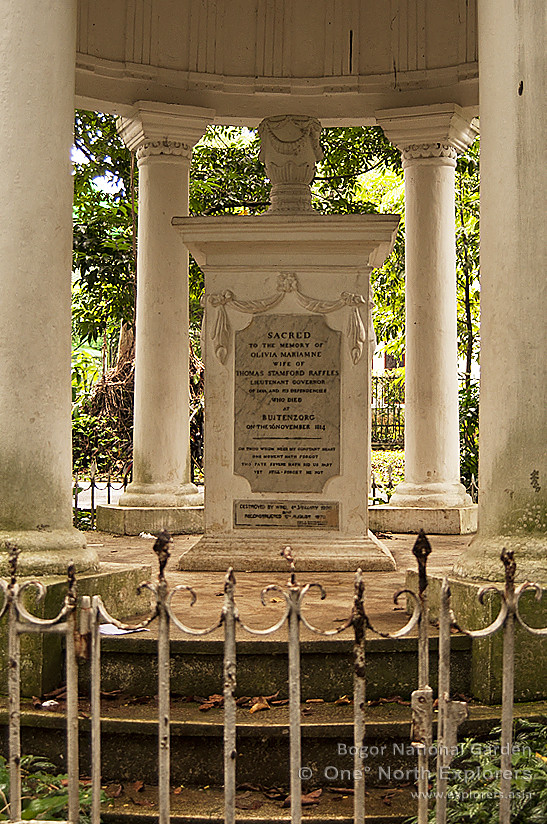
The inscription reads:

SACRED
to the Memory of
OLIVIA MARIAMNE
Wife of
the Honourable THOMAS STAMFORD RAFFLES
Lieutenant Governor 
OF JAVA
And its Dependancies
Who departed this life
Buitenzorg
The 26th day of November 1814

BINGO! The sweat, mosquito bites and fatigue was worth it. This tomb here is an important piece of history not only to the Javanese people, but also to us as Raffles went on from Java to found Singapore. Any tiredness I had felt before had instantaneously disappeared. Here it was, right before my eyes, a fragment of our colonial past.

I went around the tomb with renewed vigour, snapping away as I circled the majestic final resting place of Olivia Mariamne Raffles. Thoughts filled up my mind. What if Olivia Raffles did not fall victim to her illness during her stay in Java? What if she had followed Raffles to Singapore? What changes would she have implemented as the First Lady of the founder of Singapore? So many what-ifs popped into my mind. It was simply fascinating.

On the front of the tomb, there was a small plate which was added much later (probably by the curator) to help identify the tomb as well.


I found the inscription amusing as the words "Keterangan: Bentuk Kijing" on the plate actually meant "Description: The Shape of a Gravestone". It also depicts the year that the grave was completed (1814), the inventory number (probably as a record for the museum) and most importantly the name of the grave's occupant.

While setting up my tripod for this shot below, I noticed that the Central Jakarta Mayor's office was the backdrop of my photo. Olivia Mariamne Raffles' tomb was one of the closest ones in proximity to the Mayor's office. Since this newer building was built over what was originally part the former cemetery grounds, the cemetery's boundary would have extended far beyond the reaches of the Mayor's Office.

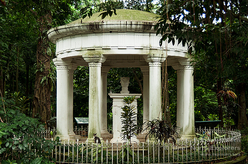
You may compare Olivia Mariamne Raffles's grave with the memorial Sir Stamford Raffles built for her in near the Lieutenant-Governor's palace in Buitenzorg (present-day Kebun Raya Bogor) below.  You may click to enlarge the photos or view the full set here.


There was boisterous singing and clapping coming from a group of people who were dressed in similar clothing within the grounds of the mayor's office, breaking the silence in the cemetery. A group of government servants having some sort of team-building activity, maybe?

I stood back and looked at the eight short columns surrounding the tomb. Although they look like they were built to symbolize the cardinal points of the compass, these columns were actually part of a Dutch church.When the church was deemed too old and unsafe to be used anymore, the stone from the church was reused to decorate the tomb of Olivia Mariamne Raffles. The eight columns, which used to support the old church's roof, were then shortened and placed around the tomb as an ornament.

The tomb of John Casper Leyden, the Scottish writer, doctor, poet and brilliant oriental linguist who was a close friend of the Raffleses, lies in close proximity to Olivia Raffles's tomb as well.

John Leyden and Olivia Raffles had often exchanged letters and poetry with each other and he was well known to be a bosom friend of Sir Stamford Raffles and a confidant of the couple. The two had met when Leyden, who left British India after spending two years there studying the mystic eastern languages of Hindustani, Tamil, Sanskrit, Malay among others, set sail for Malaya in 1805 where he befriended a young Stamford Raffles on Prince of Wales Island (Pulau Penang). Raffles was the assistant secretary to the Governor of Penang, Philip Dundas, at that time.

In 1811, Leyden joined Lord Minto in the expedition to Java. Leyden fell to the infamous Batavian Fever (an epidemic at that time, it was possibly malaria or dengue) after entering a library (which was said to have contained many Eastern manuscripts) without having the place properly aired first. After three days of illness, he died on 28 August 1811.


More Fascinating Tombs Around Taman Prasasti


While Olivia Raffles's tomb may be of more significance to us, there are many more interesting tombs around Taman Prasasti which are worth taking a look at. Although my little mission was complete, I was determined to seek out more unusual tombs for photo opportunities in the area.


The Tomb of Dirk Anthonius Varkevisser

Standing like a grand monument, the tomb of Dirk Anthonius Varkevisser towers over the tombs in the vicinity.


Dirk Anthonius Varkevisser, an official of the Dutch East Indies government, was born in Samarang (present-day Semarang in Central Java) on 11th July 1800 and passed away on 4th January 1857 in Batavia. He was the former Dutch resident of Pasuruan (in east Java, near to the city of Surabaya), and he was also knighted and conferred the Order of the Netherlands Lion, a Dutch order awarded to eminent individuals from all walks of life, including generals, ministers, mayors, leading scientists, industrialists and high ranking civil servants, among others.

His tombstone has the following inscription:

HULDE
AAN DE NAGEDACHTENIS VAN
DIRK ANTHONIUS
VARKEVISSER
IN LEVEN
OUD RESIDENT VAN PASOEROEANG
RIDDER DER ORDE VAN DEN NEDER
LANDSCHEN LEEUW GEBOREN TE
SAMARANG DEN 11DEN JULY 1800
OVERLEDEN TE BATAVIA
DEN 4
DEN JANUARY 1857

Translation:

TRIBUTE
TO THE MEMORY OF
DIRKANTHONIUS
VARKEVISSER
IN HIS LIFETIME
FORMERRESIDENTOFPASURUAN
KNIGHTOF THEORDEROFTHENETHERLANDS LION
BORN IN SEMARANG ON THE 11
TH JULY 1800
DECEASEDINBATAVIA
ON THE4
THJANUARY1857


A high-relief set of agricultural tools is prominently displayed on the front face of Dirk Varkevisser's tomb, among them a winnow fan used in wind winnowing, scythes and sickles for harvesting crops, a spade for digging the earth and many other assorted tools used for farming and soil cultivation. This is because as the Dutch Resident of Pasuruan, Varkevisser oversaw the cultivation of many cash crops, which included the highly profitable sugar cane, and he was also in charge of the production of sugar. These crops, which were significantly cheaper to cultivate in Java, were then transported back to the Netherlands in large ships to meet the demand of the Dutch population back home.

The sculptural monument of Varkevisser's tombstone is a simply stunning piece of art which has been well preserved since 1857 until the present day, a hefty feat considering that the tomb is almost a century and a half old.


The Bourgeois Family Tomb of The van Delben Family

This unique mausoleum, which is shaped like a small house, was a family tomb for the wealthy  bourgeoisie van Delben family. The head of the van Delben family was Ambrosius Johannes Wilbrordus van Delben.

During the transformation of the cemetery into the Taman Prasasti Museum, the mausoleum was opened up and the workers found the mummified bodies of the van Delben family stored inside the crypt. The bodies have since been removed and the mausoleum is currently used as a storage shed for the museum.

No one knows where the mummified bodies are presently. They would have most probably been brought back to the Netherlands or buried in another cemetery in Jakarta to make way for the museum.
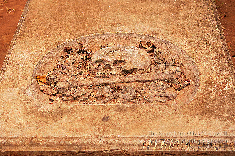


The Tragic Story of Pieter Elberfeld

Most people who visit the Taman Prasasti Museum would be intrigued by the sight of a memorial decorated with a macabre sight, a human skull pearched upon an upright spear. This uncanny memorial belongs to Pieter Elberfeld, a rebel who was brutally quartered by the Dutch government for high treason.


Born in Java in the year 1663 to a German father and a Javanese mother, Pieter Elberfeld was one who clung to native ideas and customs, which subsequently led him to become an enthusiastic and daring patriot. He hated the Dutch and all connected with them and resolved on the extermination of every Dutchman from the soil of Java.

When his father died, Pieter Elberfeld inherited a huge estate from his father. The VOC government, under the orders of then Governor-General Hendrick Zwaardecroon, exercised their superior authority by claiming a part of the estate. Incensed by their move, Elberfeld came up with a plan to kill the higher ranking officials of the VOC. Alas, before he could carry out his plan, his niece - who had fell in love with a Dutch official from the VOC - spilled the beans on her uncle. The government then caught him red-handed in the midst of a secret meeting and imprisoned him immediately. After hours of torture, Elberfeld confessed to his plans and was sentenced to death along with 19 of his slaves.


The punishment was very cruel, even for the standards of that time. He was bound backward to a cross, decapitated and his body was cut in four pieces (and not quartered by horses as popularly depicted) The four pieces of his body were hung in the four quarters of the city and the similar punishment was administered to his accomplices. He was 59 years old at that time.

Elberfeld's house, which was located outside the city then, was demolished and a schandmuur (wall of shame) was erected in its place. Elberfeld's head was set conspicuously upon a top of a pike to serve as a warning to the rest of Batavia. Over time, only the skull was left. It was then thickly plastered over to protect it from the influence of time and weather.


The Schandmuur - Circa 1885
Creative Commons - Tropenmuseum

Immediately below the transfixed skull, a tablet bearing the following long inscription in the Dutch can be found:

Uik eene verfoeyelyke gedachtenise tegen den gestraften landverrader, Pieter Elberfeld, zal niemaud vermogen ter dezer plaatse to boumen, Simmeren, metselem, planten. iiu, of tenccurrige, dage. Batavia, den 22nd April, 1722.

The translation goes roughly like this:

In consequence of the detested memory of Pieter Elberfeld, who was punished for treason, no one shall be permitted to build in wood, or stone, or to plant anything whatsoever in these grounds, from this time forth for evermore. Batavia, 22nd April, 1722


The street where Pieter Elberfeld's execution took place is now known as Jalan Pecah Kulit or "Ruptured Skin Street", a morbid name which best describes the history of the place. The Schandmuur, together with the skull on the iron pike, was then shifted to Taman Prasasti prior to the museum's opening. From the old photo of the Schandmuur and the recent one I took at Taman Prasasti, you could see that great measures were taken to remove the original wall from its original location to the museum.


Another Weeping Lady Statue

Apart from the Weeping Beauty, a second weeping lady statue can be found further in the park. Similar to the Weeping Beauty, this statue is sculptured in the Renaissance style too and there are also no visible inscriptions to tell us who the grave belongs to.


The special thing about this tomb is the usage of corals in its fabrication. The weeping lady is seen leaning onto a rock mound made out of plastered rocks and corals. Can you spot them?


The Tomb with The Broken Doric Column


This tomb is decorated with a broken doric column (like the ones at the entrance of Taman Prasasti) which reminded me of the ancient Greek architecture used for the Parthenon. A wreath is sculptured around the column to lend an air of prestige to the tomb. It was the final resting place for a lady named C.M van Os, which according to the inscription on the headstone, was the beloved wife of I. H. R. Goedhart.


The Mysterious Alpha - Omega Grave

There lies a large, wide tomb not too far away from Dirk Varkevisser. This tomb is visibly much wider than any other tomb in the museum, and it has the distinct Greek alphabets A (Alpha) and Ω (Omega) inscribed on it. These are the first and last letters of the Greek alphabet. In the Book of Revelation, Jesus Christ refers to himself as the Alpha and the Omega, symbolizing the beginning and the end of all creation.

Above the Greek alphabets, a Latin Verse reads:

INTUENTES . EXITUM . IMITAMINI . FIDEM . HEBR XIII

This is in facta part of a verse from the Bible, which translates into the following:

Remember those who led you, who spoke the word of God to you; and considering the result of their conduct, imitate their faith. - Hebrews 13:7

There used to be a stone sphere on either side of the tomb, but as you can see in the picture below, the sphere on the right had been dislodged and now lies broken on the grave floor.


The occupants (yes,there were 2 occupants) of the tomb must have been very pious Catholics indeed. Apart from the Alpha - Omega reference and the biblical verse in Latin, a religious symbol known as the Chi Rho Cross can also be found in the centre of the grave.


The first two letters of Christ's name in Greek are X and P. In the Greek alphabet X is pronounced as Chi and P is pronounced as Rho, hence the name Chi Rho Cross. These two letters are usually inscribed as one over the other and enclosed within a circle, thus becoming both a cosmic and a solar symbol. Although not technically a cross, the Chi Rho invokes the crucifixion of Jesus as well as symbolizing his status as the Christ.

The occupants of this grave also happen to be strange bedfellows, in my opinion. On the left, we have the following inscription:

Dutch:

HIER RUST
DE
JAVAANSCHE
VROUW
MABISA.
ECHTGENOOT VAN
H.LASTDRAGER
OVERLEDEN DEN
11 SEP 1860

English:
HERE LIES
THE
JAVANESE
WOMAN
MABISA.
SPOUSE OF
H.LASTDRAGER
DECEASED ON
11 SEP 1860

It seems that one of the tomb's occupants, Mabisa, was a native Javanese lady married to a Dutchman named H. Lastdrager. While I was logically expecting to see the tombstone of Mabisa's husband on the right side of the tomb, I was totally perplexed to see the following inscription instead:

Dutch:

A. SCHULTHEISS
CEB: te BERN 1830
OVERL: 13 JULI 1886
R.I.P

English:

A. SCHULTHEISS
BORN in BERN 1830
DEC: 13 JULY 1886
R.I.P

Who was this A. Schultheiss? Schultheiss is a last name of German origin, which made sense for this gentleman since he was born in Bern, the capital of Switzerland. How was he related to the Lastdragers, and why is he being buried next to Mabisa instead of her husband? A real puzzle, indeed.


The Pastor of Batavia

The tomb of H. van der Grinten, the head pastor of Batavia between 1847 - 1848, is also located in Taman Prasasti. Among the hundreds of gravestones, his benevolent statue cuts a fine figure.


Father van der Grinten was the head pastor of the Catholic Church of Batavia - the first Catholic church in Batavia - located at the corner of Lapangan Banteng (a large open square situated in an European enclave and formerly known as Waterloopein). It was built over the former residence of the Dutch East Indies military commander General Hendrik Merkus de Kock (who later was made Baron for his triumph over Prince Diponegoro in the Java war).

The church was inaugurated on 6 November 1829 and blessed by the head pastor at that time, Father L. Prinsen,  as "The Church of Our Lady of Assumption". It measured 35 long by 17 metres wide, consisted of a large hall with rows of pillars on either side in the neo-gothic style, a common architectural style for churches at the time. Father van der Grinten lived in the priest's residence on the east wing of the church, while the sacristan lived in the west wing.

The church stood until 9 April 1890 when it collapsed due to old age and poor maintenance. A new church was rebuilt in its place between 1891 and 1901 and today it stands as the Jakarta Cathedral. The church is acknowledged as an integral instrument for the spread of Roman Catholicism in Java during the 19th century.

The inscription on Father van der Grinten's tomb reads:

DOOR
ARMEN EN RIJKEN
KRIJGSMAN AND BURGER
WEDUWE EN WEES
TER ZALIGER NAGEDACHTENIS VAN DEN WELEERW-HEER

H. VAN DER GRINTEN
PASTOR DE BATAVIA
GEBN TE EINDHOVEN DEN  2DEN NOVR 1811
EN ALHIER OVERLN DEN 23 JANY 1864

 "IK BEN ALLES VOOR ALLEN GEWORDEN"
1 COR. IX v:22

"ZYNE NAGEDACHTENIS ZAL NIET VERGAAN" 
"EN ZIJN NAAM ZAL GENOEMD WORDEN"
"VAN GESLACHT TOT GESLACHT"
ECCLESE XXXIX Vs 13

- R . I . P -

 
Translation:

BY
RICHANDPOOR
WARRIORANDCITIZENS
WIDOWAND BE
INSACRED MEMORY, REVERENDOFTHE LORD

H. VAN DER GRINTEN
PASTOROF BATAVIA

"To the weak I became weak, that I might win the weak; I have become all things to all men, so that I may by all means save some."
1 Corinthians 9:22

"His memory will not perish"
"And his name will be called"
"From generation to generation"
Ecclesiasticus 39:13

- R . I . P -


Major General J.J Perie's Gothic Tomb

In the northwestern corner of Taman Prasasti, I came across a magnificent tomb which could fit right into Transylvania like a glove. This gothic looking tomb belongs to Major General J. J. Perie,  the Commanderof the 1stGroote Militaire Afdeeling (literally the Great Military Division)inJava.  During his illustrious career with the military, he was knighted and conferred with the 4th Order of the Militaire Willems-Orde (Military Order of William), the oldest and highest honour of the Kingdom of the Netherlands. This chivalric order was often presented to senior military officers in recognition of their feats of bravery on the battlefield and as a meritorious decoration. The receipient of several awards during his lifetime, Major General Perie was also awarded the Order of the Netherlands Lion.


Major General Perie passed away in 1853 in Batavia. Due to his military rank and appointment, he was given a grand and honourable funeral and buried in Batavia itself. The high-relief hatchment on his tomb consists of a Galea (a Roman soldier's helmet), a Gladius (Roman sword) and a wreath.


Further up, the upper hatchment displays an array of military flags, swords, drums and pistols. From this hatchment, we could tell that Major General Perie was a military man. (Compare this to the hatchment of Dirk Varkevisser - which consisted of agricultural tools - as seen earlier)


For Asians, it is very common to find larger tombs for the wealthy or people who were very important (take O.G Khouw for instance!). I guess the same can be said for the Dutch! From the size and grandeur of his grave, we could see the importance of Major General J. J. Perie's contributions to the Dutch East Indies government in Batavia.


Endnotes

Apart from my main task of locating Olivia Raffles's tomb, the discovery of other tombs along the way and the interesting stories behind them were pretty gratifying for me. The many different tombs of Petamburan and Taman Prasasti were bewitching and I had much joy in discovering the tomb of O.G Khouw in the process. The many amazing stories behind each tomb were simply fascinating. I hope that you have enjoyed reading the memoir as much as I had enjoyed carrying out my research and writing it.

As Greg Anderson once said “Focus on the journey, not the destination. Joy is found not in finishing an activity but in doing it.", nothing can be further from the truth.


Is he?

As it stands, there are slightly over one thousand tombs in Taman Prasasti, each with their own story to tell. There are several more tombs of significance located in the area, like the tombs of Soe Hok Gie (an Chinese-Indonesian activist who fought for the rights of the Chinese community during the reign of presidents Sukarno and Suharto), Major General Johan Harmen Rudolf Khöler (a Dutch general who died in the Aceh war), Major General Andreas Victor Michiels (a highly successful Dutch general who triumphed over his native opponents in many skirmishes), Ms. Riboet (a hugely popular actress and recording artiste in the 1920s) and many, many others whom I am unable to mention in one breath alone. Perhaps one day I will return to document all these tombs and find out about the magnificent stories behind them. In my opinion, Taman Prasasti deserves a dedicated website of its own, documenting each individual tomb, their unique designs, their inscriptions and of course the back story of the deceased.

Our writer strikes a pose with the highlight of his journey - the tomb of Olivia Raffles

Just before I sign off, I'd like to draw everyone's attention to this - remember when I said that Taman Prasasti was in fact a museum, and that the bodies have been removed from the many colourful tombs during its renovation between 1975 and 1977?

The big question is: while her tomb remains intact in Taman Prasasti, where did they relocate Olivia Raffles's body to?

That's perhaps my cue to embark on another mission in the near future, to sniff out the location and final resting place of Olivia Raffles.

Do join me again when I set foot for that. Until then, take care.

A complete set of the author's photos taken in Taman Prasasti can be found here.


Article & Photos copyright of Aaron "Six Stomachs" Chan

© One° North Explorers


Forgotten places, secret spots, historical sites or some interesting information to share. Is there a location/venue you want us to visit and document? Do you own or take care of a historical/heritage/interesting location/artifact or urban legend which you think would make a good feature?

Do drop us an email to discuss or provide/share us with a proposed location's/artifact’s accessibility, information and descriptions.


sgurbex @ gmail . com


.

The Lost Sultanate of Bantam

$
0
0
To all boxing fans, does the word "Bantamweight" ring a bell? (pun intended). A class used for boxers who are smaller in size, the "bantam" in "bantamweight" is actually derived from the Bantam Chicken, a small variety of poultry. European ships, which often stopped by the Sunda Straits en route to the Spice Islands, would call at the port of Bantam (Banten in the local tongue) to restock their supplies. They found a small breed of chicken sold in the markets of Bantam and it came to be known as a "Bantam" or "Bantam Chicken" after the port city.

A Bantam Rooster. Despite their smaller size, they can get quite
aggressive when disturbed and a real force to reckoned with.


Strategically located in the northwest of Java, the Sultanate of Banten had some of the busiest ports of the 16th century as numerous Europeans came to the Indonesian archipelago looking to dominate the spice trade.

Banten was actually founded by Sunan Gunungjati or more popularly known as Fatahillah, a well known figure in Indonesian history. He is credited as the man who first spread the religion of Islam to Java and Sumatra, which were largely influenced by Hinduism at that time. After defeating the Kingdom of Sunda, he chose Banten as the regional centre of his Sultanate, the first Muslim Sultanate ever established in the East Indies and established the centre of his kingdom in the northwest of Java.

Banten provided an important trading platform for teas, silk and ceramics from China, spices from the Philippines and pepper from the East Indies to be coordinated and shipped back to the lucrative European markets. The present-day location of Jakarta, then known as Jayakarta, was also under the control of the Sultanate of Banten. However, before the colonial intervention of the Dutch in the East Indies, the port of Jayakarta was less significant as compared to the main port of Bantam in Banten Girang, the central seat of power of the Sultanate of Banten  on the banks of the Cibanten (translated as the Banten River - "Ci" is the Sundanese word for river)


The first Dutch fleet, led by explorer Cornelis de Houtman, first called at Bantam on its expedition to the archipelago in 1596, before it went on to explore other parts the Spice Islands. de Houtman was eventually killed during a skirmish with the Sultanate of Aceh's navy, which was led by the legendary female admiral Malahayati. After going through the trials and tribulations of the sea voyage, the original crew of 249 men had been reduced to 87 by the time the ship returned to the Netherlands. Despite this, it was perceived as a symbolic victory for the Dutch as it meant that they had found a way to establish a shipping route to wrest control of the spice trade in Europe away from the monopoly of the Portuguese.

The Dutch East India Company was set up in 1602 and it gradually dominated the spice trade in the East Indies by setting up a trading post in Banten. Following this move, the British followed suit and they were soon joined by the Danish as well.

Banten had traditionally been strong in the pepper trade since the early days of its founding as its second Sultan - Mulana Hasanudin - cleverly established his foothold on southern Sumatra, where the bulk of pepper production came from. The wealth generated from the trade of pepper alone made the Sultanate of Banten one of the most richest and powerful Sultanates in that era. At one time, the Sultanate comprised almost all of Sunda - the entire western end of Java - and all of southern Sumatra as well.

Paddy fields of present-day Banten Province, near to the Sultan's Palace


However, the Sultanate started to decline after the Dutch arrived. The VOC (Dutch East India Company) conquered the port of Jayakarta from Bantam after conflicts arose over both parties over the pepper trade in 1619. The Dutch Governor-General, Jan Pieterszoon Coen, then founded Batavia (present-day Jakarta) on the ruins of Jayakarta and it became the center of the VOC's operations. Batavia had become a serious rival for Bantam.

There were also several armed conflicts between the Sultanate of Banten and the VOC during the middle of the 17th century which weakened the Sultanate further. In 1752, the foothold of the Sultanate in southern Sumatra was lost to the VOC.

The Sultanate was subsequently annexed by the Dutch Governor-General,  Herman Willem Daendels, in 1808. The 18th Sultan of Banten, Aliyuddin II, was captured when he refused to cooperate in his orders to shift the Sultanate to Anyer following the commisioning of the construction of the Great Post Road by the Dutch Government. To top it off, the Dutch envoy who was sent to Bantam to deliver this message was beheaded by the Sultan and his head was sent back to Daendels, a move that incensed the Dutch further. Daendels commanded a force which greatly outnumbered the Sultanate and stormed the grounds of Banten. The Surosowan Palace (known as the Keraton Surosowan in the local language), long occupied by the Sultans of Banten since the start of the empire, was also destroyed by the Dutch forces as a result of the invasion.


The Sultanate finally came to an end in 1813 when the last Sultan of Banten, Muhamad Syafiuddin, was forced to relinquish his throne by Sir Stamford Raffles - the Lieutenant Governor of Java - following the Dutch's capitulation to the British in the Java campaign. The Sultanate of Banten lasted from 1527 to 1813.

The rich history of Banten, and the fragments of the past which remain, were certainly worth visiting. In order to narrow down on the traces of this lost Sultanate, I knew I had to visit the former seat of power in the northwest of Java. The capital of the Sultanate of Banten is located in the vicinity of the present day "Banten Lama" or Old Bantam, in the Serang Regency, a two hour drive from Jakarta.

Before I embarked on my journey, I asked Hardi - a local nature / exploring enthusiast and personal friend of mine - if he would like to join me in this little adventure a few days prior to my planned trip before. He replied "Of course!" emphatically before I could say Jabodetabek.  With Hardi's immense knowledge of local history and culture, as well as his fluency in the Sundanese and Bantenese languages (the most widely spoken languages in Banten province), I knew I was in good hands. We had also been exchanging stories and our exploration experiences prior to this trip so I knew Hardi was a pretty experienced explorer in these parts. Needless to say, I felt thankful for having a seasoned local joining me on my maiden trip to Banten province.

My local explorer friend, Hardi. Beside three local languages, he speaks a fair amount of Dutch (his paternal grandparents were Dutch - that explains his fairer skin tone)
and a smattering of German.
Our drive from Jakarta to Serang was largely uneventful, save for the occasional buffalo or goat grazing by the roadside. When we entered Serang, the roads were flooded in some parts due to the rain in the previous evening and that slowed things down a little. En route to Surosowan Palace, our first destination, we passed by an old colonial bridge in Banten Lama which ran parallel to the new steel bridge which facilitates traffic across the Cibanten river.

"This bridge was built by the sweat and blood of the Indonesian people as part of the Jalan Raya Pos as directed by Willem Daendels. Many died during the construction of the road." said Hardi. The Jalan Raya Pos, (Der Grote Postweg in Dutch) or the Great Post Road is a 1000 kilometer stretch of road connecting Anyer in the west of Java and Panarukan in the east of Java. It was built mainly for military reasons as a main supply route to protect the northern Javanese coast against the threat of a British invasion. As Hardi had pointed out earlier, many had died in the construction process, which took just a year to complete.


Who could have imagined the hardship that the locals had to suffer 
during the construction of Der Grote Postweg?
Kids on the bridge playing with plastic bags tied to ropes, pulling them against the current.
The Cibanten's flow seems pretty much stronger after the rain. 
I wonder how many bags they've lost.
After a short drive past beautiful padi fields flanking us on both sides, we arrived at the outer walls of Surosowan Palace. I was stumped by the beauty of these age-old walls. The faded stone walls must have seen so much over the last half few centuries, a silent witness to the glories of the former Sultanate.


Surosowan Palace stands in ruins today, a pale ghost of its former glory. The palace was partially destroyed during the Dutch blitzkrieg on the largely outnumbered Sultanate of Bantam, and after the Dutch overran and occupied the area, William Daendels made his madcap plan to tear down the palace. The significance of the palace and its association with the royal family gave the Dutch enough reason to destroy it completely. A new Dutch government building was then constructed in Serang using the bricks and other materials cannibalized from the ruins of the palace, stripping it to its bare foundations which we see today. This Dutch building is now the Governor of Banten's Office in Serang, a town about 10 km from the ruins of Surosowan Palace.

A broken column shows that at least two different materials
were employed in the construction of the palace.
Hardi added this haunting sentence as we walked towards the entrance of the palace ruins: "Whatever the Dutch could use, they took. Whatever they couldn't, they burnt it to remove it altogether."

When we approached the iron gate which granted access to the hallowed ruins, I noticed that the stone wall which encloses the palace had 2 layers - a thinner outer layer seemingly made from stone and a thick inner layer made from brick and mortar.


"Ah, I see that you've noticed." said Hardi. "Come closer, let me show you something interesting." We went even closer to the wall. "Look at this." said Hardi as he pointed at a part of the outer wall.
It may look like a regular stone wall, but as i looked where Hardi was pointing, it became evident that the wall was anything but normal. I inspected the lighter-coloured material which he was pointing at. The wavy patterns on the surface only reminded me of one thing on earth that could look like that. "Is that a piece of Coral?" I asked.


"Yes. Batu Karang (Coral)." It turns out that these were no mere blocks made from stone but instead they were made from coral rag (a rubbly limestone composed of coral reef material material). The reason for the employment of coral rag was simple enough. Corals are strong and tough enough to withstand the weather and since dried up coral reefs are usually huge in scale around the archipelago, it is much more easier to obtain and therefore cheaper than conventional materials such as stone.


Stepping through the gates, I had my first glimpse of the palace ruins. It was hauntingly beautiful.
Hardi was visibly excited at this point too as he started walking around, taking photos for his own collection. I followed suit, wanting to capture as much of this beautiful place as I could.

Red bricks leading up to the portico.
Broken pieces, just like that of a jigsaw puzzle, waiting to be solved.
Hardi was fast!
When Maulana Hasanudin was appointed as the second Sultan of Banten, the palace was only a simple building surrounded by a fence during his reign (1525-1552). The additional buildings, fortifications and features were added later by the long line of Sultans. The palace has been refurbished at least five times, and it was even destroyed in a civil war between Sultan Ageng Tirtayasa and his son, Sultan Haji, and rebuilt later. The two were known to be loggerheads over the latter's insistance to cooperate with the Dutch while the former chose to refrain from working with foreigners. Following this war which Sultan Haji formerly won, his efforts to restore the broken palace proved to be futile as unhappy subjects broke down the palace once again over their dissatisfaction with his actions.


The silent ruins of the former royal palace of Banten have so much to tell.
The palace's additional features are often attributed to Hendrik Lucasz Cardeel, a Dutch architect who later converted to Islam. He proposed the addition of bastions above the fortification wall and several other European inspired features. In fact, owing to the Europeans' love for water features, the various fountains and baths in the compound may have also been his idea.

Since it was destroyed in 1808, no one really knows how the palace really looked like. It is believed that the Palace covered an area of some 30,000 square meters with walls that ran 2 meters high. A moat also used to encircle the palace to defend it against invaders and it was said to be so wide that a small ship could sail through it en route to the Java Sea, a short distance away from the palace.

One of the former halls where the Sultans received guests.
The original terracotta tiles are still pretty much intact.
A few key features of the palace, which still stand their ground today, gives us a precious look at how sophisticated the royal architects and engineers were. The infrastructure of the palace was ahead of its time, where a complex network of culverts ensured that fresh water was supplied to the palace at all times. The palace also has a series of pools where the occupants could bathe leisurely.
These ruins in the background are believed to be that of the royal kitchen. Who knows what gourmet dishes were created here for the tasting pleasure of the royal family?
Stepping through the gates, I noticed that the entrance was curved, a most unique design. This was to prevent outsiders from looking into the palace area. Also, in the event of war, the curved entrance prevented opposing forces from firing hand-held ranged weapons directly at the palace.

The entrance to the ruins of Surosowan Palace.
A closer look at the curved entrance.
As we entered from the south entrance, we were in closest proximity to the grand halls and bedrooms of the royal family. Hardi drew my attention to one in particular - the Queen's chambers. Apparently her bedroom had a large concave space underneath the floorboard where water would run through, drawing heat away and cooling the temperature in the room. However, this feature has since been covered by earth and overgrown with weeds.

The Queen's Chambers lies in a crumbled mess.
A part of the Queen's Chambers. A small bathroom, perhaps?
"The water supplied to the palace is actually from a small lake called Tasikardi. It is located not too far from here." explained Hardi as he led me towards an open square-shaped hole in the ground. I looked into the hole. It had a flat bottom, making it a void shaped like a rectangle, and was lined with the same red bricks found around the palace.

"This is actually one of the many purification filters in the palace. You can see an inlet over here and an outlet over here." Hardi pointed towards two holes on opposite sides of the filter. It seemed to be either a sediment type filter, or, more likely filled with gravel and sand to block off any impurities while running water passed through. The two grooves you see in the photo above were used to channel rainwater into the filter as well. From the number of filters, we could see how water was a going concern for the palace.

There was a large pool near to this filter, measuring 30 meters long, 13 meters wide and 4.5 deep. It may look like a toxic cesspool of questionable sludge now but in fact this was the royal bath area for the princesses of Banten. It was known as the Roro Denak and there was a building in the middle known as the Bale Kambang or Floating Hall. Where fresh water once ran, the pool is now algae infested and murky.

The Bale Kambang
A stone's throw away from the Roro Denak, a pool of a much smaller scale can be found. Known as the Pancuran Mas or Golden Fountain, this was the bath area for the palace officials. There used to be copper taps in the area but these have since been removed by looters, who probably stole the taps thinking that they were made of gold due to the misleading name. Today, the short flight of stairs lead down to a pool filled with mud and debris.

Another water feature lies to the north, a rectangular pool where the Dayang-Dayang or ladies-in-waiting could bathe. Unlike the Rara Denok, the Dayang-Dayang pool was long and rectangular in shape, and much smaller.

Just above the Dayang-Dayang pool was a rather large opening with an arch on top. The opening was a part of the fortification wall and it seemed in lead in from outside. "That's actually the inlet bringing fresh water in from Tasikardi. The water will be purified along the way by three filter houses before it arrives at the palace. Tasikardi was essentially a man-made reservoir serving the needs of the palace."

To the west of this, we found a complex network of water troughs which seem to lead into a larger trough below. The way these troughs were placed suggested that they were connected to a catchment point coming from above.

If you guessed the roofs, you're absolutely right. Banten enjoys fairly high precipitation throughout the year so it was a wise idea to harness the rainwater collected from the roofs. The rainwater would be channeled into bamboo gutters in the roofs and flow into the culverts which lead to larger water troughs for filtration.

Below the water troughs, we find yet another pool which had a unique curved staircase leading down. This was the ablution pool where the Sultan would cleanse and purify himself before he carried out his prayers in the prayer hall beside the pool. Now, the deserted pool suffers the same fate as Pancuran Mas, waterlogged and filled with rubbish, debris and dirt.

As we examined the ablution pool, we came across some metal pipes sticking out from the wall. These modern looking pipes do not seem to fit into the era that the pool was built. Were they added later? What was their function? To fill up the ablution pool when it was dry? It remains a mystery to us.

Hardi examines the seemingly modern pipes.
The Prayer hall was large and could easily accommodate thirty men. However, this was a private hall reserved exclusively for the Sultan's use. He would conduct his prayers here everyday except for Fridays, where he would join the community at the Masjid Agung (Grand Mosque) on Fridays for their Solat Jumat (Friday Prayers). The prayer hall is located in the northwestern corner of the palace and faces the direction of Mecca.

Next to the palace, I was rather surprised to find a perfectly manicured football pitch within the palace walls. "That part has not been excavated yet. Who knows what they might find underneath all that soil in the future?"

Excavation works were carried out on the palace sometime back but was stopped for unknown reasons. Today the archaeological work on the palace seems half-done it is hard to tell if they would be continued in the future. Until the, this part of the palace remains a football pitch for the local community.

From the prayer hall, we found a way to ascend to the top of the north fortification wall. The fortification walls of the palace were definitely thick enough to withstand heavy firepower from cannons. The outer and inner walls, which measure 1 metre in width each, both sandwich a buffer layer of earth which measures a whopping 3 metres. Lookout posts on each corner also allowed the palace guards to keep vigil on the surroundings and fire at assailants from higher ground, while the moat kept opposing foot soldiers at bay.

View from the top of the north fortification wall. Note the thickness of the wall.
Culvert bringing fresh water in from Tasikardi.
A small creek just outside the palace walls. A part of the former moat, perhaps?
From our position on the palace walls, it was evident that all traces of the former bastions and the moat have been completely removed.

On our way out of the palace, we found a collapsed part of the a building, a wall perhaps? This gives us an idea of how thick the walls of some parts of the palace were. This particular piece measured slightly more than a metre thick. 

After snapping the last of our pictures of the palace, Hardi and I decided to bid the palace farewell and to move on to our next area of interest, the Masjid Agung and the former town centre of Banten.

These were found all over the palace and they were the work...
...of these guys. They were grazing all over the palace.
As we exited the forlorn gates of Surosowan Palace, we entered into the bustling marketplace.
It was hard to imagine that we had just stepped out of such a deserted and quiet world beyond those iron gates into a busy street lined with stalls on both sides.

Hawkers were peddling everything from fried food, fruits, clothing toys and even obat kuat, a questionable medicine which claims to strengthen men's performance.

Pete (known affectionally as Petai or Smelly Bean in Singapore) is
a popular bean sold almost everywhere in West Java
The inner reaches of the marketplace were not properly paved and the ground, which had been exposed to the rain earlier, had turned into a muddy mess. It was slippery and the mud was ankle deep in some parts, an absolute nightmare to walk on. Some enterprising kids started handing out plastics bags for a thousand rupiah each - the locals who bought them simply took off their shoes, placed them in the bags and walked barefoot in the mud.

After the muddy experience, we soon arrived at the side of the Grand Mosque of Banten (Masjid Agung Banten Lama). The first thing I noticed was the unique minaret. It looks exactly like a lighthouse!

With the sea only a short distance away, the octoganal minaret was a lookout point during the old days, apart from being a focal point and to provide the call for prayer. Curiously, it was also used as an armoury where weapons were stored. The lighthouse was designed by Hendrik Lucasz Cardeel, the same person who proposed and designed the European-inspired features of Surosowan Palace.

The minaret is a twenty four metre brick tower and one could ascend a narrow staircase to the top where interesting views of Banten could be had. However, the minaret was closed from the public today as there was a prayer session going in inside the mausoleum area. The place was simply jam-packed with people today.

The entrances to the prayer hall are slightly shorter than normal and most people have to bend their heads when they entered the mosque. The design is believed to be ordered by Sultan Maulana Hasanuddin and it ensures that everyone entering the prayer hall will bend and bow their heads, therefore showing a humble gesture of respect for the holy place.

The ablution pools of Masjid Agung.
The Grand Mosque of Banten was established according to the traditions of the past, which states that there should be four components in an Islamic city. First of all, there should be a Palace as the seat of government and a residence for the Sultan, a duty which was duly fulfilled by Surosowan Palace. Secondly, there should be a mosque where the subjects could congregate for worship. Thirdly, there should be a town square which acted as the center of activity and for passing out information.  And last but not least, there should be a market for economic activity. Out of the four components, only the Grand Mosque and the market remain in the present day to give us a glimpse of  Banten's illustrious past.

The main mosque building and the minaret have been around since the time of Sultan Maulana Hasanuddin, and the north and south wings were added later. It is said that the construction of the Grand Mosque stemmed from Sunan Gunungjati's instructions to his son, Maulana Hasanuddin. The latter was asked to find a piece of land that was sacred on which to develop the Sultanate of Banten on. Hasanuddin was on board a ship off the coast of Java when he prayed for divine help to assist him in his task. After his prayers, the waves spontaneously pushed his ship onto Banten Girang. Hasanuddin began to establish the Kingdom of Banten and its other components as a result of this event.

Sundial previously used by the Imams to tell the time to call for prayers.
The gnomon (shadow casting object) is missing, rendering it purely ornamental now.
On the southern side of the mosque, a contemporary Dutch-style rectangular tiyamah (Pavilion) was used as an important meeting place. Today the building functions as a museum of relics. On the northern side, the royal graveyard and mausoleum - where a long list of Sultans were buried, among them Sultan Maulana Hasanuddin and his queen; Sultan Ageng Tirtayasa and Sultan Haji - can be found. The royal mausoleum is a popular place for pilgrims who travel there to pray for the Sultan. It is believed that those who do so, will be blessed with good fortune. Judging by the long queue, I could see the true faith of the sheer droves of people who had come from afar to offer their prayers.

Unlike other mosques in Java where the mosque's founder's tomb is located in the west by tradition,  Sultan Maualana Hasanuddin's tomb is located on the north side of the mosque.

Prayers were going on in the royal mausoleum so I had to snipe from afar.
That creepy old tree looks right at home in the royal graveyard.
We headed east in the direction of the former town square as we departed the mosque. There was a large gateway demarcating the entrance to the town square and where a waterlogged football pitch with makeshift goalposts stands now. (These people sure love football.) Another important part of Banten's history, gone and probably never coming back.

Rudimentary, but definitely effective
Another interesting relic we wanted to check out before we left the town centre was the Watu Gilang or Stone of Gilang. This stone was used as a ceremonial throne during the swearing in of each new Sultan. Legend states that the stone once belonged in Pakuan, the capital city of the Sunda Kingdom. When the Sundanese were defeated by the Sultanate of Banten, the stone was brought back to Banten by Sultan Maulana Hasanuddin under the orders of his father.

The legendary Watu Gilang
The stone was believed to have mystical powers and helped to bring wealth and prosperity to any kingdom which owned it. This seemed to be true for Banten as they expanded their vast empire upon placing this stone in their Sultanate. However, it is also said that the stone should not be moved, for misfortune would befall on the Sultanate and it come to a swift and tragic end.

The Watu Gilang was used for swearing in purposes between the second to the sixth Sultan, while a second stone called the Watu Singayaksa, located not too far away from here, was used from the seventh Sultan onwards. The stone is a precious piece of history and mysticism indeed, but today it lies neglected amongst the various stalls, often ending up as the bed of a stray cat or dog. 

From this position, we decided to take a walk to Tasikardi, which was about two kilometres away from the town centre. Soon enough, we were away from the hustle and bustle of the market and surrounded by rice fields. As we walked along, Hardi explained the workings of Surosowan Palace's water filtration system.

"The water from Tasikardi is channeled via clay pipes through three filter houses, namely Pengindelan Abang (Red Filter), Pengindelan Putih (White Filter) and Pengindelan Emas (Gold Filter) along the way to the palace. The water from Tasikardi will pass through Pengindelan Abang and be certified red quality, afterwhich it passes through Pengindelan Putih and becomes white quality, and finally through Pengindelan Emas where it becomes clear and certified gold quality."

Pengindelan Abang
We soon arrived at a building which stood out lie a sore thumb among the rice fields. "This, my friend, is Pengindelan Abang." said Hardi. The building was very long and it had a conventional roof which made it look like a house.

Hardi circles the filter house to get a good shot
Former gate posts of Pengindelan Abang. 
The area used to be fenced up during the Sultanate's reign.
As we stood outside the solitary entrance to the filter house,I could hear an incessant cacophony of screeching inside.

"Bats?" I asked. Before Hardi could answer, one of the cretins flew past our heads into the entrance. Hardi grinned at me with a "I think that just answered your question" kind of look.

I stood at the doorway and looked into the filter house. The entire bottom area was flooded as expected due to the building's primary function. There was rubbish floating in the water and the stench was horrible. I took a couple of shots of the interior and ended up with these.

The water was brown, stagnant and probably teeming with millions of bacteria.
The interior does look like an air raid shelter. A couple of bats were startled by my camera's flash and flew further into the filter house. The screeching became louder when the bats detected the presence of humans "invading" their nest. Soon, it was Hardi's turn to shoot the interior of the building.

Ragged and jagged roof
After Hardi's turn to shoot the interior (which barely lasted a minute) we continued our walk to Tasikardi. Hardi seemed visibly happy to get away from the rank stench of the filter house. Trust me, the smell was overwhelming.


Hardi was happy to get away from the filter house.
We continued our walk among the rice fields, and before long, I could see a row of trees lined neatly ahead of us. "Is that the one?" I asked, to which Hardi nodded with a smile. It was hard to miss features like these when all you had around you was miles and miles of flat rice fields.

Tasikardi is fenced up and there is currently only one entrance, which we had to pay a nominal fee to enter. After walking into the perimeter of the lake, the last thing I expected to see staring back at my lens was this:

In perhaps a foolhardy attempt to spruce up the surroundings of the place, there were several statues placed near the entrance to add colour to the lake. There was a gray elephant, decapitated statues of Mickey Mouse and Donald Duck, and these guys below.

"We welcome you with open arms!"
Pity the guy below has a splitting headache.
These curious looking statues are actually the Purnakawan. Hardi explains that they are popular characters in Wayang Kulit (Javanese shadow theatre, an arcane art form practiced and loved by many in Java) who appear in many stories. They are known as the clown servants of the protagonist and their appearance was always anticipated by wayang kulit audiences.

Like the rest of the statues, they were in various stages of decay. Most were missing an arm or a leg, while some had their brains split open. It was not a pretty sight. If the intention of putting these statues was to beautify the place, it certainly was not helping at all.

OMG they killed Mickey.
Fanny - not a good name at all.
Moving on from the statues, we walked over to the bank where we could get a clear shot of the man-made island in the middle of the lake. Measuring exactly 44 metres by 44 metres, the island was a recreational area for the Sultans and it houses a pleasure pavilion and the ruins of a royal bathroom.

The name Tasikardi stands for artificial lake in Sundanese and Hardi explains that Tasikardi was built for one simple reason - to provide a source of clean water. Back in the old days, foreign vessels would call at Banten and most of the time, the crew on board would pass some diseases to the local community after being at sea for months on end. Since the locals lived in slums, it was hard to contain such diseases. Hence, Sultan Maulana Hasanuddin decided to build a lake far from the town where he could draw clean water from. The water supplied to the palace was through enclosed clay pipes so there was no way the water could be contaminated.

Tasikardi is believed to be never dry and never overflowing, and this has seemingly held true for the last few centuries. The bottom of the lake is flat and lined with the same red bricks used in the construction of Surosowan Palace.

Tasikardi and the man-made island
A weary caretaker approaches us and asks if we would like to rent a boat to the island. Looking at the light drizzle and occasional streak of lightning, we politely declined. As much as we'd like to document the island, the thought of being stuck on an island in the middle of a thunderstorm was not appealing at all.

I understand that this used to be a popular place where there were various food and game stalls available and one could partake in several recreational activities in the lake, such as paddle boats, but due to a decline in business, these proprietors have since left. The whole place feels empty and dead.

It was sad to see such places of historical significance being neglected like such. Surosowan Palace, Tasikardi, the former town square of Banten and even the three filter houses all played an importnat part in creating the first building blocks of Islam in Indonesia.

As I boarded the car for my next destination, I said a little prayer for the lake. I hope the authorities can do something about the restoration of these places and although I know that the hope is dim, I'm keeping my fingers crossed.

Broken down tram in Tasikardi rusting away


Article & Photos copyright of Aaron "Six Stomachs" Chan

Photo of Masjid Agung Ablution Pool copyright of Hardi Pribono and used with permission

© One° North Explorers


Forgotten places, secret spots, historical sites or some interesting information to share. Is there a location/venue you want us to visit and document? Do you own or take care of a historical/heritage/interesting location/artifact or urban legend which you think would make a good feature?

Do drop us an email to discuss or provide/share us with a proposed location's/artifact’s accessibility, information and descriptions.


sgurbex @ gmail . com


.
Viewing all 26 articles
Browse latest View live